
-
Federal
NACP Integrated Wildland and Cropland 30-m Fuel Characteristics Map, U.S.A., 2010
National Aeronautics and Space Administration —
The data set provides a 30-m comprehensive fuelbed characteristics map for both the wildland and cropland areas of the conterminous United States (CONUS) for 2010.... -
Federal
Global Soil Types, 0.5-Degree Grid (Modified Zobler)
National Aeronautics and Space Administration —
A global data set of soil types is available at 0.5-degree latitude by 0.5-degree longitude resolution. There are 106 soil units, based on Zobler?s (1986) assessment... -
Federal
Global Food Security-support Analysis Data (GFSAD) Cropland Extent 2015 South America product 30 m V001
National Aeronautics and Space Administration —
The NASA Making Earth System Data Records for Use in Research Environments (MEaSUREs)... -
Federal
Global Food Security-support Analysis Data (GFSAD) Cropland Extent-Product 2015 Validation 30 m V001
National Aeronautics and Space Administration —
The NASA Making Earth System Data Records for Use in Research Environments (MEaSUREs)... -
Federal
SAFARI 2000 Carbon in Live Vegetation, 0.5-Deg (Olson)
National Aeronautics and Space Administration —
This data set is a subset of Olson's Major World Ecosystem Complexes for southern Africa in ASCII GRID and binary image files formats. Olson's Major World Ecosystem... -
Federal
SHIFT: Wetland Spectra, Salinity, and Fractional Cover, Devereux Slough, CA, 2022
National Aeronautics and Space Administration —
This dataset includes field data, analysis code, and corresponding airborne imagery collected and generated during the 2022 NASA Surface Biology Geology (SBG) High... -
Federal
Global Soil Texture and Derived Water-Holding Capacities (Webb et al.)
National Aeronautics and Space Administration —
A standardized global data set of soil horizon thicknesses and textures (particle size distributions) was compiled by Webb et al. This data set will be used for the... -
Federal
Global Hyperspectral Imaging Spectral-library of Agricultural crops for Central Asia V001
National Aeronautics and Space Administration —
The Global Hyperspectral Imaging Spectral-library of Agricultural crops (GHISA) is a comprehensive compilation, collation, harmonization, and standardization of... -
Federal
BOREAS TE-18 Geosail Canopy Reflectance Model
National Aeronautics and Space Administration —
The SAIL (Scattering from Arbitrarily Inclined Leaves) model was combined with the Jasinski geometric model to simulate canopy spectral reflectance and absorption of... -
Federal
LBA-ECO LC-08 Soil, Vegetation, and Land Cover Maps for Brazil and South America
National Aeronautics and Space Administration —
This data set provides (1) soil maps for Brazil that are digital versions of the MAPA DE SOLOS DO BRASIL (EMBRAPA, 1981) classified at three levels of detail,... -
Federal
Wetland Salinity Maps of Select Estuary Sites in the United States, 2020
National Aeronautics and Space Administration —
This dataset provides gridded average annual wetland salinity concentrations in practical salinity units (PSU) at 30-meter resolution within 24 coastal estuary sites... -
Federal
Global Hyperspectral Imaging Spectral-library of Agricultural crops for Conterminous United States V001
National Aeronautics and Space Administration —
The Global Hyperspectral Imaging Spectral-library of Agricultural crops (GHISA) is a comprehensive compilation, collation, harmonization, and standardization of... -
Federal
Global Space-based Stratospheric Aerosol Climatology Version 1.1
National Aeronautics and Space Administration —
The Global Space-based Stratospheric Aerosol Climatology, or GloSSAC, is a 38-year climatology of stratospheric aerosol properties focused on extinction coefficient... -
Federal
Land Surface Model (LSM 1.0) for Ecological, Hydrological, Atmospheric Studies
National Aeronautics and Space Administration —
The NCAR LSM 1.0 is a land surface model developed by Gordon Bonan to examine biogeophysical and biogeochemical land-atmosphere interactions, especially the effects... -
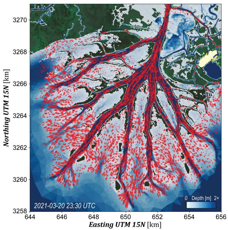
Federal
Delta-X: Calibrated ANUGA Hydrodynamic Outputs for the Atchafalaya Basin, MRD, LA
National Aeronautics and Space Administration —
This dataset provides ANUGA hydrodynamic modeling results and input run-scripts for the Atchafalaya basin in the Mississippi River Delta in southern Louisiana, USA,... -
Federal
Helicopter MMR Reflectance Data (SNF)
National Aeronautics and Space Administration —
A major aspect of the ground data collection effort in the SNF during the summers of 1983 and 1984 was the acquisition of helicopter canopy reflectance measurements.... -
Federal
BOREAS RSS-04 1994 Jack Pine Leaf Biochemistry and Modeled Spectra in the SSA
National Aeronautics and Space Administration —
The BOREAS RSS-04 team focused its efforts on deriving estimates of LAI and leaf chlorophyll and nitrogen concentrations from remotely sensed data for input into the... -
Federal
BOREAS TE-20 Supplementary Site Information For NSA Tower Sites
National Aeronautics and Space Administration —
The BOREAS TE-20 team collected several data sets for use in developing and testing models of forest ecosystem dynamics. This data set and documentation were compiled... -
Federal
Arctic Vegetation Plots at Atqasuk, Alaska, 1975, 2000, and 2010
National Aeronautics and Space Administration —
This data set provides vegetation species abundance data collected in 1975 from 60 sites on the Arctic Coastal Plain near Atqasuk, Alaska, as well as environmental...

Official websites use .gov
A
.gov website belongs to an official government
organization in the United States.
Secure .gov websites use HTTPS
A
lock (
) or https:// means you’ve safely connected to
the .gov website. Share sensitive information only on official,
secure websites.