
-
Federal
ASTER Global Digital Elevation Model V003
National Aeronautics and Space Administration —
The Terra Advanced Spaceborne Thermal Emission and Reflection Radiometer (ASTER) Global Digital Elevation Model (GDEM) Version 3 (ASTGTM) provides a global digital... -
Federal
MODIS/Terra Land Water Mask Derived from MODIS and SRTM L3 Global 250m SIN Grid V006
National Aeronautics and Space Administration —
The MOD44W Version 6 data product was decommissioned on July 18, 2024. Users are encouraged to use the MOD44W Version 6.1 data product... -
Federal
Shuttle Radar Topography Mission (SRTM) Version 2
National Aeronautics and Space Administration —
NASA has released version 2 of the Shuttle Radar Topography Mission digital topographic data (also known as the "finished" version). Version 2 is the result of a... -
Federal
MODIS/Terra Land Water Mask Derived from MODIS and SRTM L3 Global 250m SIN Grid V061
National Aeronautics and Space Administration —
The Terra Moderate Resolution Imaging Spectroradiometer (MODIS) Land Water Mask (MOD44W) Version 6.1 data product provides a global map of surface water at 250 meter... -
Federal
SRTM Water Body Data
National Aeronautics and Space Administration —
The SRTM Water Body Data files are a by-product of the data editing performed by the National Geospatial-Intelligence Agency (NGA) to produce the finished SRTM... -
Federal
Landsat-Derived Global Rainfed and Irrigated-Cropland Product 30 m V001
National Aeronautics and Space Administration —
The Landsat-Derived Global Rainfed and Irrigated-Cropland Product (LGRIP) provides high resolution, global cropland data to assist and address food and water security... -
Federal
ABoVE: Passive Microwave-derived Annual Snowpack Main Melt Onset Date Maps, 1988-2023
National Aeronautics and Space Administration —
This dataset provides the annual date of snowpack seasonal beginning melt (i.e., main melt onset date, MMOD) across northwest Canada, Alaska, US, and parts of far... -
Federal
ATLAS/ICESat-2 L3B Mean Inland Surface Water Data V003
National Aeronautics and Space Administration —
ATL22 is a derivative of the continuous Level 3A ATL13 Along Track Inland Surface Water Data product. ATL13 contains the high-resolution, along-track inland water... -
Federal
Human Robotic Systems (HRS): Robotic ISRU Acquisition Element
National Aeronautics and Space Administration —
During 2014, the Robotic ISRU Resource Acquisition project element will develop two technologies: Exploration Ground Data Systems (xGDS)Sample Acquisition on... -
Federal
Global Food Security-support Analysis Data (GFSAD) Cropland Extent 2015 Australia, New Zealand, China, Mongolia 30 m V001
National Aeronautics and Space Administration —
The NASA Making Earth System Data Records for Use in Research Environments (MEaSUREs) Global Food Security-support Analysis Data (GFSAD) data product provides... -
Federal
ASTER Global Digital Elevation Model Attributes NetCDF V003
National Aeronautics and Space Administration —
The Terra Advanced Spaceborne Thermal Emission and Reflection Radiometer (ASTER) Global Digital Elevation Model (GDEM) Version 3 (ASTGTM) provides a global digital... -
Federal
Merged Sentinel-3A and Sentinel-3B OLCI Regional Mapped Inland Waters (ILW) Data, version 4
National Aeronautics and Space Administration —
The Inland Waters dataset (ILW) provides data for lakes and other water bodies across the contiguous United States (CONUS) and Alaska. ILW significantly reduces the... -
Federal
SWOT Level 2 Water Mask Pixel Cloud Data Product, Version D
National Aeronautics and Space Administration —
The SWOT Level 2 Water Mask Pixel Cloud Product (SWOT_L2_HR_PIXC_D) provides high-resolution, geolocated observations of terrestrial surface water pixels detected by... -
Federal
SWOT Level 2 Water Mask Pixel Cloud Auxiliary Data Product, Version C
National Aeronautics and Space Administration —
Auxiliary information for pixel cloud product indicating to which water bodies the pixels are assigned in river and lake products. Also includes height-constrained... -
Federal
ABoVE: Passive Microwave-derived Annual Snowpack Main Melt Onset Date Maps, 1988-2018
National Aeronautics and Space Administration —
This dataset provides the annual date of snowpack seasonal beginning melt (i.e., main melt onset date, MMOD) across northwest Canada; Alaska, U.S.; and parts of far... -
Federal
GPM AMSR-2 on GCOM-W1 (GPROF) Climate-based Radiometer Precipitation Profiling L3 1 day 0.25 degree x 0.25 degree V07 (GPM_3GPROFGCOMW1AMSR2_DAY_CLIM) at GES DISC
National Aeronautics and Space Administration —
Version 07 is the current version of the data set. Older versions will no longer be available and have been superseded by Version 07. The "CLIM" products differ from... -
Federal
Merged Sentinel-3A and Sentinel-3B OLCI Regional Binned Inland Waters (ILW) Data, version 4
National Aeronautics and Space Administration —
The Inland Waters dataset (ILW) provides data for lakes and other water bodies across the contiguous United States (CONUS) and Alaska. ILW significantly reduces the... -
Federal
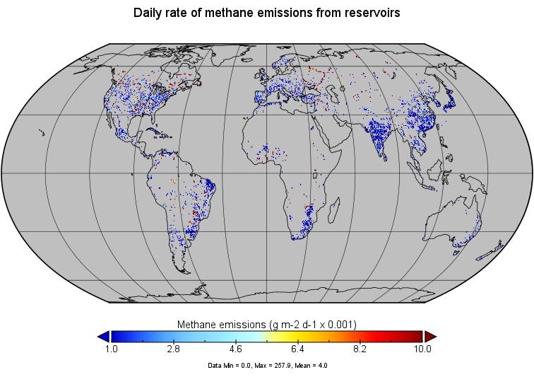
Global-Gridded Daily Methane Emissions from Inland Dam-Reservoir Systems
National Aeronautics and Space Administration —
This dataset includes global maps of methane (CH4) emissions from inland dam-reservoir systems at 0.25-degree spatial resolution. Daily emission rates (as grams of... -
Federal
LBA Regional Hydrographic Data, 1-Degree, Release 2.2 (Cogley)
National Aeronautics and Space Administration —
This subset of the Global Hydrographic data set (GGHYDRO) Release 2.2 for the study area of the Large Scale Biosphere-Atmosphere Experiment in Amazonia (LBA) in South...

Official websites use .gov
A
.gov website belongs to an official government
organization in the United States.
Secure .gov websites use HTTPS
A
lock (
) or https:// means you’ve safely connected to
the .gov website. Share sensitive information only on official,
secure websites.