
-
Federal
Global Distribution of Root Turnover in Terrestrial Ecosystems
National Aeronautics and Space Administration —
Estimates of root turnover rates were calculated from measurements of live root standing crop and belowground net primary production (BNPP) compiled from the primary... -
Federal
Global Landslide Nowcast from LHASA L4 1 day 1 km x 1 km version 1.1 (Global_Landslide_Nowcast) at GES DISC
National Aeronautics and Space Administration —
The Landslide Hazard Assessment for Situational Awareness (LHASA) model identifies locations with high potential for landslide occurrence at a daily temporal... -
Federal
ECOSTRESS Gridded Downscaled Meteorology Instantaneous L3 Global 70 m V002
National Aeronautics and Space Administration —
The ECOsystem Spaceborne Thermal Radiometer Experiment on Space Station (ECOSTRESS) mission measures the temperature of plants to better understand how much water... -
Federal
UARS Improved Stratospheric and Mesospheric Sounder (ISAMS) Level 3AL V010 (UARIS3AL) at GES DISC
National Aeronautics and Space Administration —
The Improved Stratospheric and Mesospheric Sounder (ISAMS) Level 3AL data product consists of daily, 4 degree increment latitude-ordered vertical profiles of... -
Federal
SBUV2/NOAA-18 Ozone (O3) Profile and Total Column Ozone 1 Month Zonal Mean L3 Global 5.0 degree Latitude Zones V1 (SBUV2N18L3zm) at GES DISC
National Aeronautics and Space Administration —
The Solar Backscattered Ultraviolet (SBUV) from NOAA-18 Level-3 monthly zonal mean (MZM) product (SBUV2N18L3zm) is derived from the Level-2 retrieved ozone profiles.... -
Federal
LBA-ECO CD-10 H2O Profiles at km 67 Tower Site, Tapajos National Forest
National Aeronautics and Space Administration —
This data set reports vertical profiles of H2O vapor concentrations measured at the Para Western (Santarem) - km 67, Primary Forest Tower Site (Figure 1). This site... -
Federal
NACP Site: Terrestrial Biosphere Model Output Data in Original Format
National Aeronautics and Space Administration —
This data set contains the original model output data submissions from the 24 terrestrial biosphere models (TBM) that participated in the North American Carbon... -
Federal
LBA Regional Mean Climatology, 0.5-Deg, 1930-1960, V. 2.1 (Cramer and Leemans)
National Aeronautics and Space Administration —
This data set is a subset of Cramer and Leemans' (2001) global database of mean monthly climatology, which contains monthly averages of mean temperature, temperature... -
Federal
LBA-ECO ND-03 Stream and Soil Water Data, Fazenda Nova Vida, Rondonia: 1994-2001
National Aeronautics and Space Administration —
This data set provides the results of (1) the physical and chemical characterization of streams and (2) comparable chemical analyses of extracted soil water in the... -
Federal
BASIN TCP Stable Isotope Composition of CO2 in Terrestrial Ecosystems
National Aeronautics and Space Administration —
This data set reports stable isotope ratio data of CO2 (13C/12C and 18O/16O) associated with photosynthetic and respiratory exchanges across the biosphere-atmosphere... -
Federal
LBA-ECO LC-04 Satellite/Census-Based 5-Minute Land Use Data, Amazonia: 1980 and 1995
National Aeronautics and Space Administration —
Amazonia has been under considerable development pressure as croplands and pasture are established in areas formerly occupied by tropical forest and cerrado. Although... -
Federal
UARS Halogen Occultation Experiment (HALOE) Level 3AT V019 (UARHA3AT) at GES DISC
National Aeronautics and Space Administration —
The Halogen Occultation Experiment (HALOE) Level 3AT data product consists of daily vertical profiles of temperature, aerosol extinction and concentrations of HCl,... -
Federal
HIRENASD Beam FEM
National Aeronautics and Space Administration —
This contains attempts to create BEAM FEM model. I have started a Blog to discuss this... please put your comments there and I will attempt to keep everything... -
Federal
LiDAR Derived Biomass, Canopy Height, and Cover for New England Region, USA, 2015
National Aeronautics and Space Administration —
This dataset provides 30 m gridded estimates of aboveground biomass density (AGBD), forest canopy height, and tree canopy coverage for the New England Region of the... -
Federal
CARVE: L2 Atmospheric Gas Concentrations, Airborne Flasks, Alaska, 2012-2015
National Aeronautics and Space Administration —
This data set provides atmospheric carbon dioxide (CO2), methane (CH4), carbon monoxide (CO), molecular hydrogen (H2), nitrous oxide (N2O), sulfur hexafluoride (SF6),... -
Federal
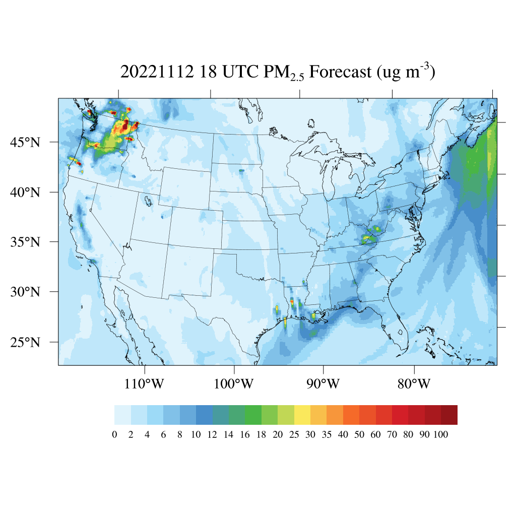
HAQES 3-Hourly Ensemble mean surface total PM2.5 concentration, North America V1 (HAQES_NA_PM25_TOT) at GES DISC
National Aeronautics and Space Administration —
This product provides HAQES 3-hourly ensemble mean surface total PM2.5 concentration over the continental United States (CONUS) and surrounding regions. The data is... -
Federal
MLS/Aura Level 3 Daily Binned Nitric Acid (HNO3) Mixing Ratio on Zonal and Similar Grids V004 (ML3DZHNO3) at GES DISC
National Aeronautics and Space Administration —
ML3DZHNO3 is the EOS Aura Microwave Limb Sounder (MLS) daily binned on zonal and assorted vertical grids product for nitric acid (HNO3) derived from radiances... -
Federal
CERES Monthly Gridded Single Satellite Fluxes and Clouds TRMM Edition2C
National Aeronautics and Space Administration —
CER_FSW_TRMM-PFM-VIRS_Edition2C is the Clouds and the Earth's Radiant Energy System (CERES) Fixed Swath Width (FSW) Monthly Gridded Single Satellite Fluxes (SSF) and... -
Federal
Global Maps of Atmospheric Nitrogen Deposition, 1860, 1993, and 2050
National Aeronautics and Space Administration —
This data set provides global gridded estimates of atmospheric deposition of total inorganic nitrogen (N), NHx (NH3 and NH4+), and NOy (all oxidized forms of nitrogen...

Official websites use .gov
A
.gov website belongs to an official government
organization in the United States.
Secure .gov websites use HTTPS
A
lock (
) or https:// means you’ve safely connected to
the .gov website. Share sensitive information only on official,
secure websites.