
-
Federal
SIRS/Nimbus-3 Level 1 Radiance Data V001 (SIRSN3L1) at GES DISC
National Aeronautics and Space Administration —
SIRSN3L1 is the Nimbus-3 Satellite Infrared Spectrometer (SIRS) Level 1 Radiance Data product. SIRS measured infrared radiation (11 to 36 micrometers) emitted from... -
Federal
SARP 2017 Data
National Aeronautics and Space Administration —
SARP_2017_Data is the data collected onboard the Wallops C-23 aircraft during the 2017 deployment of the Student Airborne Research Program (SARP) mission. Data... -
Federal
BUV/Nimbus-4 Dark Current Study Master Data V001 (BUVN4L1DCM) at GES DISC
National Aeronautics and Space Administration —
The Nimbus-4 BUV Level-1 Dark Current Study Master Data is derived from the BUV Level 1 Radiance (RUT) product and contains the geophysical indices and... -
Federal
BUV/Nimbus-4 Level 1 Radiance Data V001 (BUVN4L1RUT) at GES DISC
National Aeronautics and Space Administration —
The Nimbus-4 BUV Level-1 Radiance data collection was derived from the Primary Data Base (PDB) product and contains the calibrated and geolocated backscattered... -
Federal
CYGNSS Level 3 Ocean Microplastic Concentration Version 3.2
National Aeronautics and Space Administration —
The CYGNSS L3 Ocean Microplastic Concentration V3.2 dataset is provided by the CYGNSS Science Team of the University of Michigan.CYGNSS was launched on 15 December... -
Federal
CYGNSS L3 Ocean Microplastic Concentration V1.0
National Aeronautics and Space Administration —
This dataset contains the version 1.0 CYGNSS level 3 ocean microplastic concentration data record, which provides 18 netCDF files, each containing one month of daily... -
Federal
CYGNSS Level 3 Climate Data Record Version 1.0
National Aeronautics and Space Administration —
This dataset contains the Version 1.0 CYGNSS Level 3 Climate Data Record which provides the average wind speed and mean square slope (MSS) on a 0.2x0.2 degree... -
Federal
BUV/Nimbus-4 Level 1 Radiance and Housekeeping Data in Telemetry Units V001 (BUVN4L1PDB) at GES DISC
National Aeronautics and Space Administration —
The Nimbus-4 BUV Level-1 Radiance and Housekeeping Data in Telemetry Units collection contains the raw counts measured by the Backscatter Ultraviolet Spectrometer... -
Federal
BUV/Nimbus-4 Dark Current Study Working Data V001 (BUVN4L1DCW) at GES DISC
National Aeronautics and Space Administration —
The Nimbus-4 BUV Level-1 Dark Current Study Working Data is derived from the BUV Level 1 Radiance (RUT) product and contains the geophysical indices and... -
Federal
BUV/Nimbus-4 Level 2 Compressed Ozone Profile Data V005 (BUVN4L2CPOZ) at GES DISC
National Aeronautics and Space Administration —
The Nimbus-4 BUV Level 2 Compressed Ozone Profile Data collection or CPOZ contains total ozone, reflectivities, ozone mixing ratios and layer ozone amounts measured... -
Federal
BUV/Nimbus-4 Level 2 High-Density Ozone Data V005 (BUVN4L2HDBUV) at GES DISC
National Aeronautics and Space Administration —
The Nimbus-4 BUV Level 2 High-Density Ozone Data collection contains the vertical distribtuion and total column amount of ozone, as well as the full set of ancillary... -
Federal
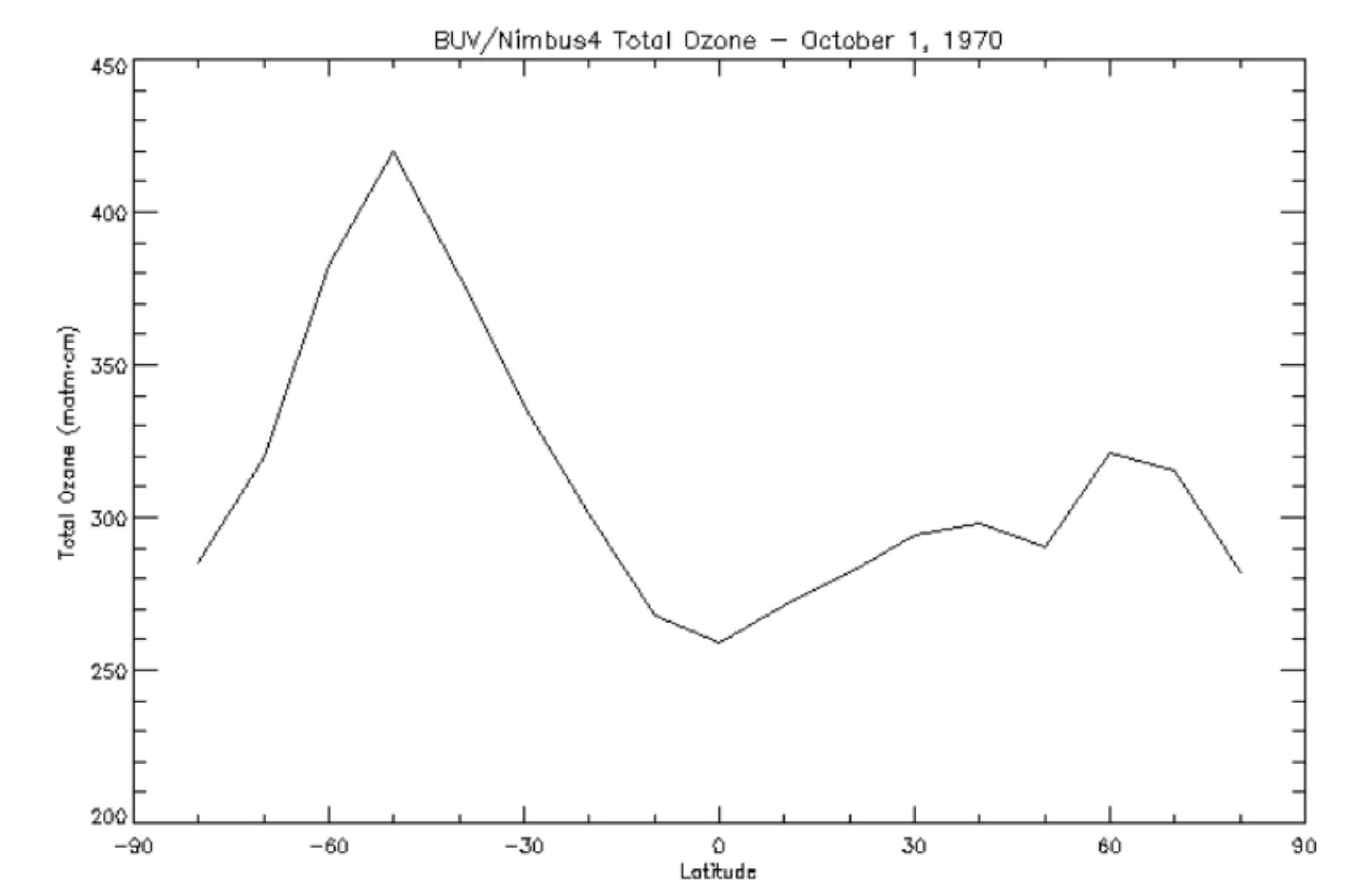
BUV/Nimbus-4 Level 3 Ozone Zonal Means V005 (BUVN4L3ZMT) at GES DISC
National Aeronautics and Space Administration —
The Nimbus-4 BUV Level 3 Ozone Zonal Means collection or ZMT contains total ozone, reflectivities, and ozone mixing ratios averaged in 10 degree latitude zones... -
Federal
HIRENASD Beam FEM
National Aeronautics and Space Administration —
This contains attempts to create BEAM FEM model. I have started a Blog to discuss this... please put your comments there and I will attempt to keep everything... -
Federal
SAFARI 2000 ER-2 Color-IR Aerial Photography, Dry Season 2000
National Aeronautics and Space Administration —
Aerial photography from the NASA ER-2 high altitude aircraft was collected to provide detailed and spatially extensive documentation over parts of the SAFARI study... -
Federal
SIRS/Nimbus-4 Level 1 Radiance Data V001 (SIRSN4L1) at GES DISC
National Aeronautics and Space Administration —
SIRSN4L1 is the Nimbus-4 Satellite Infrared Spectrometer (SIRS) Level 1 Radiance Data product. SIRS measured infrared radiation (11 to 36 micrometers) emitted from... -
Federal
CYGNSS Level 1 Climate Data Record Version 1.0
National Aeronautics and Space Administration —
This Level 1 (L1) dataset contains the Version 1.0 Climate Data Record (CDR) of the geo-located Delay Doppler Maps (DDMs) calibrated into Power Received (Watts) and... -
Federal
CYGNSS Level 2 Climate Data Record Version 1.0
National Aeronautics and Space Administration —
This dataset contains the Version 1.0 CYGNSS Level 2 Climate Data Record which provides the time-tagged and geolocated average wind speed (m/s) and mean square slope... -
Federal
MRIR/Nimbus-3 Level 1 Meteorological Radiation Data V001 (MRIRN3L1) at GES DISC
National Aeronautics and Space Administration —
MRIRN3L1 is the Nimbus-3 Medium-Resolution Infrared Radiometer (MRIR) Level 1 Meteorological Radiance Data product and contain radiances expressed as equivalent... -
Federal
Nimbus-6 Level 2 NMC Data Systems Test for the Global Atmospheric Research Program (GARP) V001 (NMCN6L2GARP) at GES DISC
National Aeronautics and Space Administration —
The NMCN6L2GARP is the Nimbus-6 Level 2 NMC Data Systems Test for the Global Atmospheric Research Program (GARP) product. The product consists of meterological... -
Federal
ACT-America: L1 Raw, Uncalibrated In-Situ CO2, CO, and CH4 Mole Fractions from Towers
National Aeronautics and Space Administration —
This dataset provides Level 1 (L1) in situ atmospheric carbon dioxide (CO2), carbon monoxide (CO), and methane (CH4) concentrations as measured on a network of...

Official websites use .gov
A
.gov website belongs to an official government
organization in the United States.
Secure .gov websites use HTTPS
A
lock (
) or https:// means you’ve safely connected to
the .gov website. Share sensitive information only on official,
secure websites.