
-
Federal
Poverty Mapping Project: Global Subnational Prevalence of Child Malnutrition
National Aeronautics and Space Administration —
The Poverty Mapping Project: Global Subnational Prevalence of Child Malnutrition data set consists of estimates of the percentage of children with weight-for-age... -
Federal
Global Reservoir and Dam Database, Version 1 (GRanDv1): Dams, Revision 01
National Aeronautics and Space Administration —
The Global Reservoir and Dam Database, Version 1, Revision 01 (v1.01) contains 6,862 records of reservoirs and their associated dams with a cumulative storage... -
Federal
VIIRS/JPSS1 BRDF/Albedo Parameter 2 Band M5 Daily L3 Global 30 ArcSec CMG V002
National Aeronautics and Space Administration —
The NOAA-20 Visible Infrared Imaging Radiometer Suite (VIIRS) Bidirectional Reflectance Distribution Function (BRDF) and Albedo Model Parameter 2 Band M5 product... -
Federal
Images of Antarctic Ice Shelves, Version 2
National Aeronautics and Space Administration —
Images of Antarctic Ice Shelves is a data set created as part of an effort to closely monitor major ice streams and outlet glaciers along the Antarctic coast, with a... -
Federal
Modeled Daily Thaw Depth and Frozen Ground Depth, Version 1
National Aeronautics and Space Administration —
This data set contains modeled daily thaw depth and freezing depth for the Arctic terrestrial drainage basin. Thaw and freezing depths were calculated over the study... -
Federal
Autonomous Parsivel Unit (APU) IMPACTS
National Aeronautics and Space Administration —
The Autonomous Parsivel Unit (APU) IMPACTS data were collected in support of the Investigation of Microphysics and Precipitation for Atlantic Coast-Threatening... -
Federal
West Africa Coastal Vulnerability Mapping: GPW Version 4 Population Density, Preliminary Release 1, 2010
National Aeronautics and Space Administration —
The West Africa Coastal Vulnerability Mapping: GPW Version 4 Population Density, Preliminary Release 1, 2010, represents the number of persons per square kilometer,... -
Federal
CAMP2Ex Cloud and Precipitation Retrievals Derived From APR-3 and AMPR Measurements
National Aeronautics and Space Administration —
CAMP2Ex-Cloud-Precip-Retrieval_1 are cloud and precipitation retrievals derived from the Advanced Precipitation Radar 3 (APR-3) and Advanced Microwave Precipitation... -
Federal
M 31 Chandra HRC X-Ray Source Catalog
National Aeronautics and Space Administration —
The authors have obtained 17 epochs of Chandra High Resolution Camera (HRC) snapshot images, each covering most of the M31 disk. The data cover a total baseline of... -
Federal
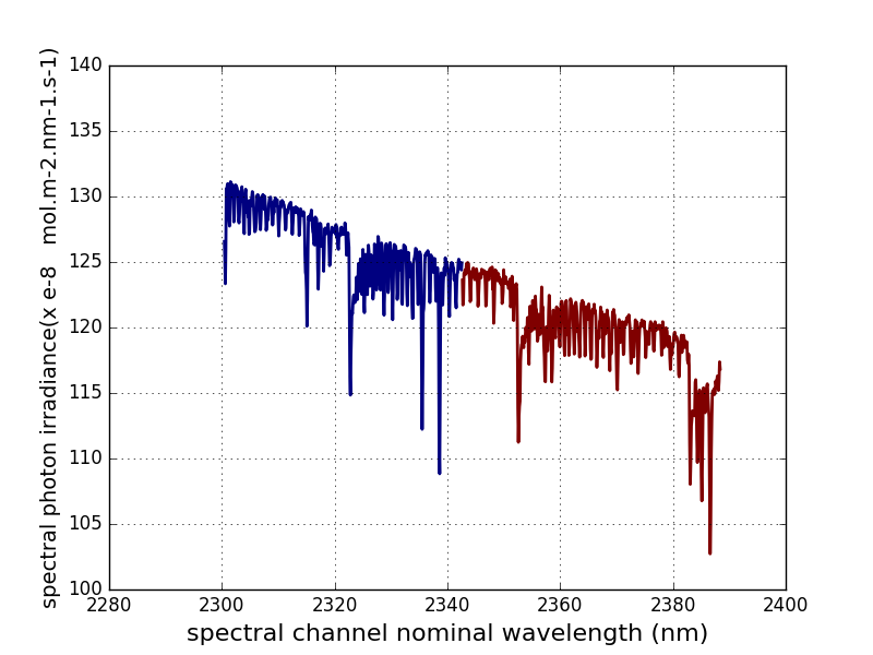
Sentinel-5P TROPOMI Irradiance product SWIR module L1B V2 (S5P_L1B_IR_SIR) at GES DISC
National Aeronautics and Space Administration —
The Copernicus Sentinel-5 Precursor (Sentinel-5P or S5P) satellite mission is one of the European Space Agency's (ESA) new mission family - Sentinels, and it is a... -
Federal
U.S. Social Vulnerability Index Grids, Revision 01
National Aeronautics and Space Administration —
The U.S. Social Vulnerability Index Grids, Revision 01 data set contains gridded layers for the overall Centers for Disease Control and Prevention (CDC) Social... -
Federal
Mobile UIUC Soundings IMPACTS V1
National Aeronautics and Space Administration —
The Mobile UIUC Soundings IMPACTS dataset consists of atmospheric sounding data collected by rawinsondes launched during the Investigation of Microphysics and... -
Federal
GPM GROUND VALIDATION NOAA SURFACE METEOROLOGICAL STATION MC3E V1
National Aeronautics and Space Administration —
The GPM Ground Validation NOAA Surface Meteorological Station MC3E dataset was collected at the NOAA Southern Great Plains Facility for the Midlatitude Continental... -
Federal
Spitzer Extragalactic Representative Volume Survey Lockman Hole 3.6 micron Catalog
National Aeronautics and Space Administration —
The "Spitzer Extragalactic Representative Volume Survey" (SERVS) Exploration Science program conducted deep IRAC 3.6 and 4.5 micron observations of five extragalactic... -
Federal
NGC 2024 Chandra X-Ray Point Source Catalog
National Aeronautics and Space Administration —
The NGC 2024 Chandra X-Ray Point Source Catalog contains the results of a sensitive 76 ks Chandra observation of the young stellar cluster in NGC 2024, lying at a... -
Federal
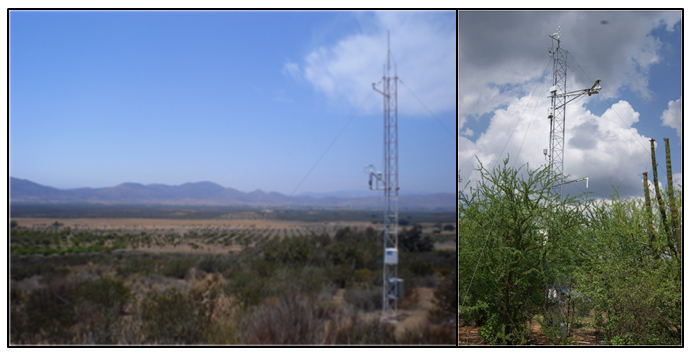
CMS: Evapotranspiration and Meteorology, Water-Limited Shrublands, Mexico, 2008-2010
National Aeronautics and Space Administration —
This data set provides daily average observations for evapotranspiration (measured and gap-filled), precipitation, net radiation, soil water content, air temperature,... -
Federal
ATLAS/ICESat-2 L3B Gridded Antarctic and Arctic Land Ice Height V004
National Aeronautics and Space Administration —
This data set contains a high-resolution (100 m) gridded digital elevation model (DEM) for the Antarctic ice sheet and regions around the Arctic. The data can be used... -
Federal
Jason-1 SGDR version E NetCDF
National Aeronautics and Space Administration —
The Sensory Geophysical Data Record (SGDR) files contain full accuracy altimeter data, with a high precision orbit (accuracy ~1.5 cm). The instruments on Jason-1 make... -
Federal
GPM GROUND VALIDATION DUAL POLARIZED C-BAND DOPPLER RADAR KING CITY GCPEX V1
National Aeronautics and Space Administration —
The GPM Ground Validation Dual Polarized C-Band Doppler Radar King City GCPEx dataset has special Range Height Indicator (RHI) and sector scans of several dual...

Official websites use .gov
A
.gov website belongs to an official government
organization in the United States.
Secure .gov websites use HTTPS
A
lock (
) or https:// means you’ve safely connected to
the .gov website. Share sensitive information only on official,
secure websites.