
-
Federal
Supercritical Airfoil Coordinates
National Aeronautics and Space Administration —
Rectangular Supercritical Wing (Ricketts) - design and measured locations are provided in an Excel file RSW_airfoil_coordinates_ricketts.xls . One sheet is with Non... -
Federal
ITPR/Nimbus-5 Level 1 Calibrated Radiances V001 (ITPRN5L1) at GES DISC
National Aeronautics and Space Administration —
ITPRN5L1 is the Nimbus-5 Infrared Temperature Profile Radiometer (ITPR) Level-1 Calibrated Radiances data product which contains radiances at 7 infrared spectral... -
Federal
UC Berkeley CYGNSS Level 3 Daily RWAWC Watermask Version 3.2
National Aeronautics and Space Administration —
The CYGNSS Level 3 UC Berkeley Watermask Record Version 3.2 was developed by CYGNSS investigators in the Department of Civil and Environmental Engineering at the... -
Federal
CYGNSS Level 3 MRG Science Data Record Version 3.2
National Aeronautics and Space Administration —
This dataset contains the version 3.2 CYGNSS level 3 science data record merged storm (MRG) wind speed which combines CYGNSS storm-centric gridded (SCG) wind speeds,... -
Federal
CYGNSS Level 1 Full Delay Doppler Map Data Record Version 3.0
National Aeronautics and Space Administration —
This Level 1 (L1) dataset contains the Version 3.0 (v3.0) Full Delay Doppler Map (DDM) sensor data from the Delay Doppler Mapping Instrument aboard the CYGNSS... -
Federal
HIRS/Nimbus-6 Level 1 Calibrated Radiances for the Global Atmospheric Research Program (GARP) V001 (HIRSN6L1GARP) at GES DISC
National Aeronautics and Space Administration —
The Nimbus-6 High Resolution Infrared Radiometer (HIRS) Level 1 Calibrated Radiances for the Global Atmospheric Research Program (GARP) data product contains daily... -
Federal
SARP 2018 Data
National Aeronautics and Space Administration —
SARP_2018_Data is the data collected onboard the NASA DC-8 aircraft during the 2018 deployment of the Student Airborne Research Program (SARP) mission. Data... -
Federal
SARP 2024 Data
National Aeronautics and Space Administration —
SARP_2024_Data is the data collected onboard the NASA P-3B and the Dynamic Aviation B200 aircrafts during the 2024 deployment of the Student Airborne Research Program... -
Federal
VISSR/SMS-2 Level 1 Atmospheric and Oceanographic Image Processing System (AOIPS) Data V001 (VISSRSMS2L1AOIPS) at GES DISC
National Aeronautics and Space Administration —
VISSRSMS2L1AOIPS is the Visible Infrared Spin-Scan Radiometer (VISSR) Level 1 Atmospheric and Oceanographic Image Processing System (AOIPS) data product from the... -
Federal
CYGNSS Level 3 MRG Science Data Record Near Real Time Version 3.2.2
National Aeronautics and Space Administration —
CYGNSS_L3_MRG_NRT_V3.2.2This dataset contains the Near Real Time (NRT) version of the 3.2.2 CYGNSS Level 3 Merged (MRG) Science Data Record Wind Speed which combines... -
Federal
CYGNSS Level 3 Ocean Microplastic Concentration Version 3.2
National Aeronautics and Space Administration —
The CYGNSS L3 Ocean Microplastic Concentration V3.2 dataset is provided by the CYGNSS Science Team of the University of Michigan.CYGNSS was launched on 15 December... -
Federal
CYGNSS Level 3 Storm Centric Grid Science Data Record Version 1.0
National Aeronautics and Space Administration —
This dataset contains the Version 1.0 Cyclone Global Navigation Satellite System (CYGNSS) Level 3 Storm Centric Grid (SCG) Science Data Record (SDR) which provides... -
Federal
CYGNSS Level 1 Full Delay Doppler Map Data Record
National Aeronautics and Space Administration —
This Level 1 (L1) dataset contains the Full Delay Doppler Map (DDM) sensor data from the Delay Doppler Mapping Instrument aboard the CYGNSS satellite constellation.... -
Federal
BUV/Nimbus-4 Dark Current Study Master Data V001 (BUVN4L1DCM) at GES DISC
National Aeronautics and Space Administration —
The Nimbus-4 BUV Level-1 Dark Current Study Master Data is derived from the BUV Level 1 Radiance (RUT) product and contains the geophysical indices and... -
Federal
BUV/Nimbus-4 Level 1 Radiance Data V001 (BUVN4L1RUT) at GES DISC
National Aeronautics and Space Administration —
The Nimbus-4 BUV Level-1 Radiance data collection was derived from the Primary Data Base (PDB) product and contains the calibrated and geolocated backscattered... -
Federal
CYGNSS L3 Ocean Microplastic Concentration V1.0
National Aeronautics and Space Administration —
This dataset contains the version 1.0 CYGNSS level 3 ocean microplastic concentration data record, which provides 18 netCDF files, each containing one month of daily... -
Federal
SARP 2015 Data
National Aeronautics and Space Administration —
SARP_2015_Data is the data collected onboard the NASA DC-8 aircraft during the 2015 deployment of the Student Airborne Research Program (SARP) mission. Data... -
Federal
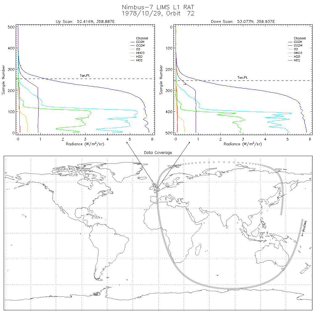
LIMS/Nimbus-7 Level 1 Radiance Data V001 (LIMSN7L1RAT) at GES DISC
National Aeronautics and Space Administration —
LIMSN7L1RAT is the Nimbus-7 Limb Infrared Monitor of the Stratosphere (LIMS) Level-1 Radiance Data product. It contains calibrated, earth-located radiances, as well... -
Federal
HRIR/Nimbus-2 Level 1 Meteorological Radiation Data V001 (HRIRN2L1) at GES DISC
National Aeronautics and Space Administration —
HRIRN2L1 is the High Resolution Infrared Radiometer (HRIR) Nimbus-2 Level 1 Meteorological Radiance Data (NMRT) product and contains infrared radiances converted to...

Official websites use .gov
A
.gov website belongs to an official government
organization in the United States.
Secure .gov websites use HTTPS
A
lock (
) or https:// means you’ve safely connected to
the .gov website. Share sensitive information only on official,
secure websites.