
-
Federal
Prediction Of Worldwide Energy Resources (POWER)
National Aeronautics and Space Administration —
The POWER Project contains over 380 satellite-derived meteorology and solar energy Analysis Ready Data (ARD) at four temporal levels: hourly, daily, monthly (by year... -
Federal
REGIONAL AIR-SEA INTERACTION (RASI) GAP WIND AND COASTAL UPWELLING EVENTS CLIMATOLOGY GULF OF PANAMA, PANAMA V1
National Aeronautics and Space Administration —
The Regional Air-Sea Interactions (RASI) Gap Wind and Coastal Upwelling Events Climatology Gulf of Panama, Panama dataset was created using an automated intelligent... -
Federal
PSP Solar Wind Electrons Alphas and Protons (SWEAP) SPC Ion Number Density, Velocity, and Thermal Speed Momemts and Fits, Level 3 (L3), 0.2185 s Data
National Aeronautics and Space Administration —
SPC Level 3 Ion Data--------------------File Naming Format: psp_swp_spc_l3i_YYYYMMDD_v01.cdfThis data product contains derived measurements of ion properties in the... -
Federal
TOLNet NASA Langley Research Center Data
National Aeronautics and Space Administration —
TOLNet_LaRC_Data is the lidar data collected by the Langley Mobile Ozone Lidar (LMOL) at NASA Langley Research Center (LaRC) as part of the Tropospheric Ozone Lidar... -
Federal
SARP 2010 Data
National Aeronautics and Space Administration —
SARP_2010_Data is the data collected onboard the NASA DC-8 aircraft during the 2010 deployment of the Student Airborne Research Program (SARP) mission. Data... -
Federal
Hurricane and Severe Storm Sentinel (HS3) Statistical Hurricane Intensity Prediction Scheme (SHIPS) Intensity V1
National Aeronautics and Space Administration —
The Hurricane and Severe Storm Sentinel (HS3) Statistical Hurricane Intensity Prediction Scheme (SHIPS) Intensity dataset was obtained from March 18, 2014 through... -
Federal
MERRA-2 tavgU_3d_udt_Np: 3d,diurnal,Time-Averaged,Pressure-Level,Assimilation,Wind Tendencies 0.625 x 0.5 degree V5.12.4 (M2TUNPUDT) at GES DISC
National Aeronautics and Space Administration —
M2TUNPUDT (or tavgU_3d_udt_Np) is a 3-dimensional monthly diurnal means data collection in Modern-Era Retrospective analysis for Research and Applications version 2... -
Federal
GRIP HURRICANE IMAGING RADIOMETER (HIRAD) V1
National Aeronautics and Space Administration —
The GRIP Hurricane Imaging Radiometer (HIRAD) V1 dataset contains measurements of brightness temperature taken at 4, 5, 6 and 6.6 GHz, as well as MERRA 2 m wind speed... -
Federal
CYGNSS Level 3 MRG Science Data Record Near Real Time Version 3.2.1
National Aeronautics and Space Administration —
This dataset contains the version 3.2.1 CYGNSS Level 3 Merged (MRG) Science Data Record Near Real Time (NRT) Storm Wind Speed derived from the Delay Doppler Mapping... -
Federal
Polar Ozone and Aerosol Measurement II Version 6
National Aeronautics and Space Administration —
POAM2_VER6 data are Polar Ozone and Aerosol Measurement II Version 6.0 data. The Polar Ozone and Aerosol Measurement (POAM) II instrument measures the vertical... -
Federal
SARP 2009 Data
National Aeronautics and Space Administration —
SARP_2009_Data is the data collected onboard the NASA DC-8 aircraft during the 2009 deployment of the Student Airborne Research Program (SARP) mission. Data... -
Federal
The VIIth Catalog of Galactic Wolf-Rayet Stars
National Aeronautics and Space Administration —
The VIIth Catalogue of Galactic Population I Wolf-Rayet (WR) Stars provides improved coordinates, spectral types, and bv photometry of known WR stars and adds 71 new... -
Federal
SOHO Charge, Element, and Isotope Analysis System (CELIAS) Proton Monitor (PM) 5-minute Solar Wind Data in CDF Format
National Aeronautics and Space Administration —
The data include 5-minute proton speed, density, most probable thermal speed, and arrival direction, as well as predicted alpha-particle speed. Also included are the... -
Federal
MISR Level 2 TOA/Cloud Stereo Product subset for the GoMACCS region V002
National Aeronautics and Space Administration —
GOMI2ST_002 is the Multi-angle Imaging SpectroRadiometer (MISR) Level 2 TOA/Cloud Stereo Product subset for the GoMACCS region version 2. It contains the... -
Federal
TOLNet NOAA Chemical Sciences Laboratory Data
National Aeronautics and Space Administration —
TOLNet_CSL_Data is the lidar data collected by the Tunable Optical Profile for Aerosol and oZone (TOPAZ) lidar at the NOAA Chemical Sciences Laboratory (CSL) in... -
Federal
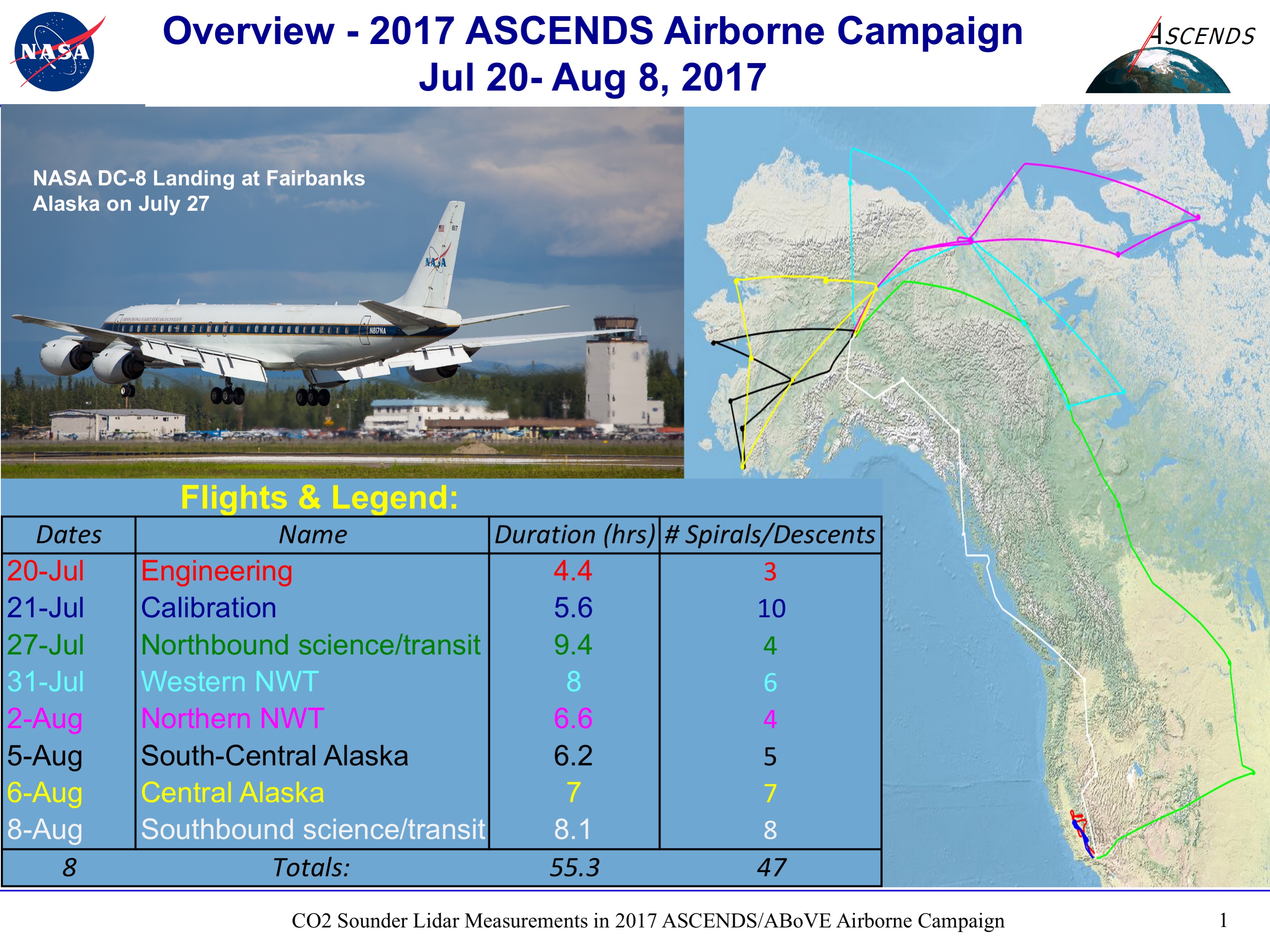
ABoVE/ASCENDS: Merged Atmospheric CO2, CH4, and Meteorological Data, 2017
National Aeronautics and Space Administration —
This dataset provides in situ airborne measurements of atmospheric carbon dioxide (CO2), methane (CH4), water vapor concentrations, air temperature, pressure, and... -
Federal
ISEE 1 Solar Wind Weimer Propagation Details at 1 min Resolution
National Aeronautics and Space Administration —
ISEE-1 Weimer propagated solar wind data and linearly interpolated time delay, cosine angle, and goodness information of propagated data at 1 min Resolution. This... -
Federal
GPM Ground Validation NASA ER-2 Navigation Data IPHEx V1
National Aeronautics and Space Administration —
The GPM Ground Validation NASA ER-2 Navigation Data IPHEx dataset was gathered during the GPM Ground Validation Integrated Precipitation and Hydrology Experiment... -
Federal
Wind Radio/Plasma Wave, (WAVES) Hi-Res Parameters CDF
National Aeronautics and Space Administration —
Wind Waves RAD2, RAD1, and TNR data in CDF format. RAD1 RAD1 is the low frequency radio astronomy receiver. It sweeps over the range of 20 to 1040 kHz with as many as... -
Federal
IBEX High Energy Neutral Atom Imager (Hi) Data Release 04, Compton-Getting corrected, Survival Probability corrected, Omnidirectional, West Longitude Ecliptic Maps, Level H3 (H3), semiannually averaged Data
National Aeronautics and Space Administration —
1: The Interstellar Boundary Explorer (IBEX) has operated in space since 2008 updating our knowledge of the outer heliosphere and its interaction with the local...

Official websites use .gov
A
.gov website belongs to an official government
organization in the United States.
Secure .gov websites use HTTPS
A
lock (
) or https:// means you’ve safely connected to
the .gov website. Share sensitive information only on official,
secure websites.