

13 datasets found for "Wildlife"
-
Federal
ABoVE: Passive Microwave-derived Annual Snowpack Main Melt Onset Date Maps, 1988-2023
National Aeronautics and Space Administration —
This dataset provides the annual date of snowpack seasonal beginning melt (i.e., main melt onset date, MMOD) across northwest Canada, Alaska, US, and parts of far... -
Federal
Geoecology: County-Level Environmental Data for the United States, 1941-1981
National Aeronautics and Space Administration —
The Geoecology database is a compilation of environmental data for the period 1941 to 1981. The Geoecology database contains selected data on terrain and soils, water... -
Federal
ABoVE: Permafrost Measurements and Distribution Across the Y-K Delta, Alaska, 2016
National Aeronautics and Space Administration —
This dataset provides field observations of thaw depth and dominant vegetation types, a LiDAR-derived elevation map, and permafrost distribution and probability maps... -
Federal
BOREAS SERM Forest Fire Chronology of Saskatchewan in Vector Format
National Aeronautics and Space Administration —
This data set is a series of ARC/INFO export files of the fire history of Saskatchewan by year from 1945 to 1996, with a few missing years. The data set was compiled... -
Federal
LiDAR-based Biomass Estimates, Boreal Forest Biome, Eurasia, 2005-2006
National Aeronautics and Space Administration —
This data set provides estimates of aboveground biomass (AGB) for defined land cover types within World Wildlife Fund (WWF) ecoregions across the boreal biome of... -
Federal
BOREAS Follow-On DSP-09 Saskatchewan Raster Forest Fire Chronology, 1945-1996
National Aeronautics and Space Administration —
This data set contains a pair of raster images and a spreadsheet chronicling the most recent fire history of Saskatchewan from 1945 to 1996. This data set was... -
Federal
Snow Properties and Wildlife Tracks in Washington and Alaska
National Aeronautics and Space Administration —
This dataset contains three field seasons of snow-wildlife observations conducted at 707 sites from January 2021 to March 2023 in Washington and Alaska, spanning a... -
Federal
SAFARI 2000 Historical Fire Maps, Kruger National Park, 1992-2001
National Aeronautics and Space Administration —
Kruger National Park (KNP) was established in 1898 to protect wildlife on nearly 2 million hectares of the South African Lowveld. The climate in this region of South... -
Federal
RLC AVHRR-Derived Land Cover, Former Soviet Union, Far East, 1-km, 1990
National Aeronautics and Space Administration —
This data set is a 1-kilometer resolution land cover map for the land area of the Primor'ye and Southern Khabarovsk Regions, in the Russian Far East, based on 1990... -
Federal
NACP LiDAR-based Biomass Estimates, Boreal Forest Biome, North America, 2005-2006
National Aeronautics and Space Administration —
This data set provides estimates of aboveground biomass (AGB) for defined land cover types within World Wildlife Fund (WWF) ecoregions across the boreal biome of... -
Federal
LBA-ECO LC-01 National, Provincial, and Park Boundaries, Ecuador
National Aeronautics and Space Administration —
This data set contains the national and provincial boundaries of Ecuador as well as the boundaries of two national parks: the Cuyabeno Wildlife Reserve and the Yasuni... -
Federal
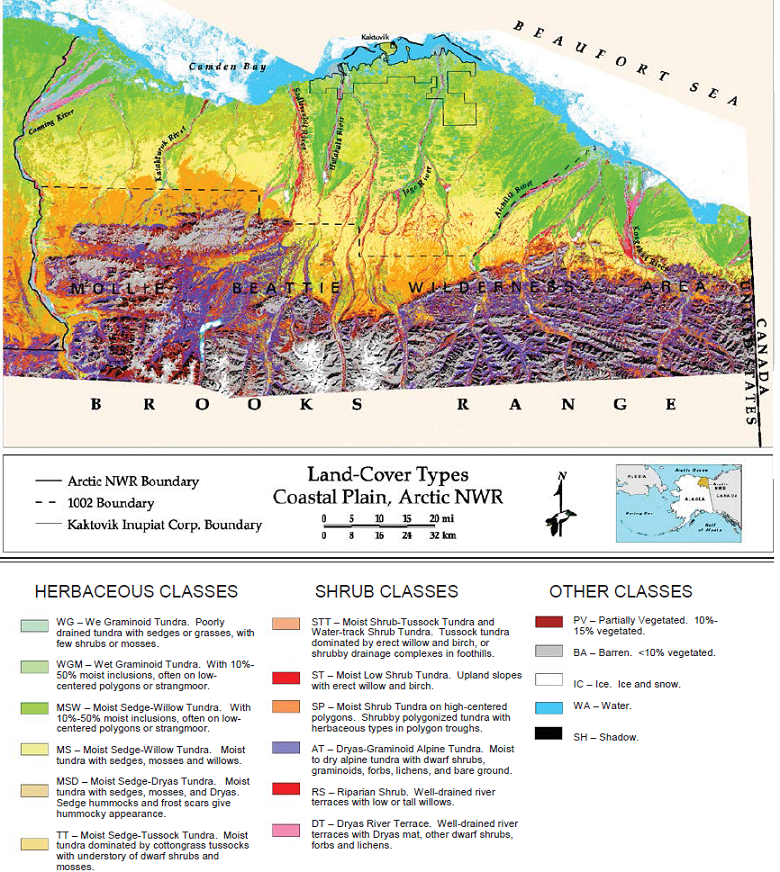
Land Cover and Vegetation Map, Arctic National Wildlife Refuge
National Aeronautics and Space Administration —
This data set provides a landcover map with 16 landcover classes for the northern coastal plain of the the Arctic National Wildlife Refuge (ANWR) on the North Slope... -
Federal
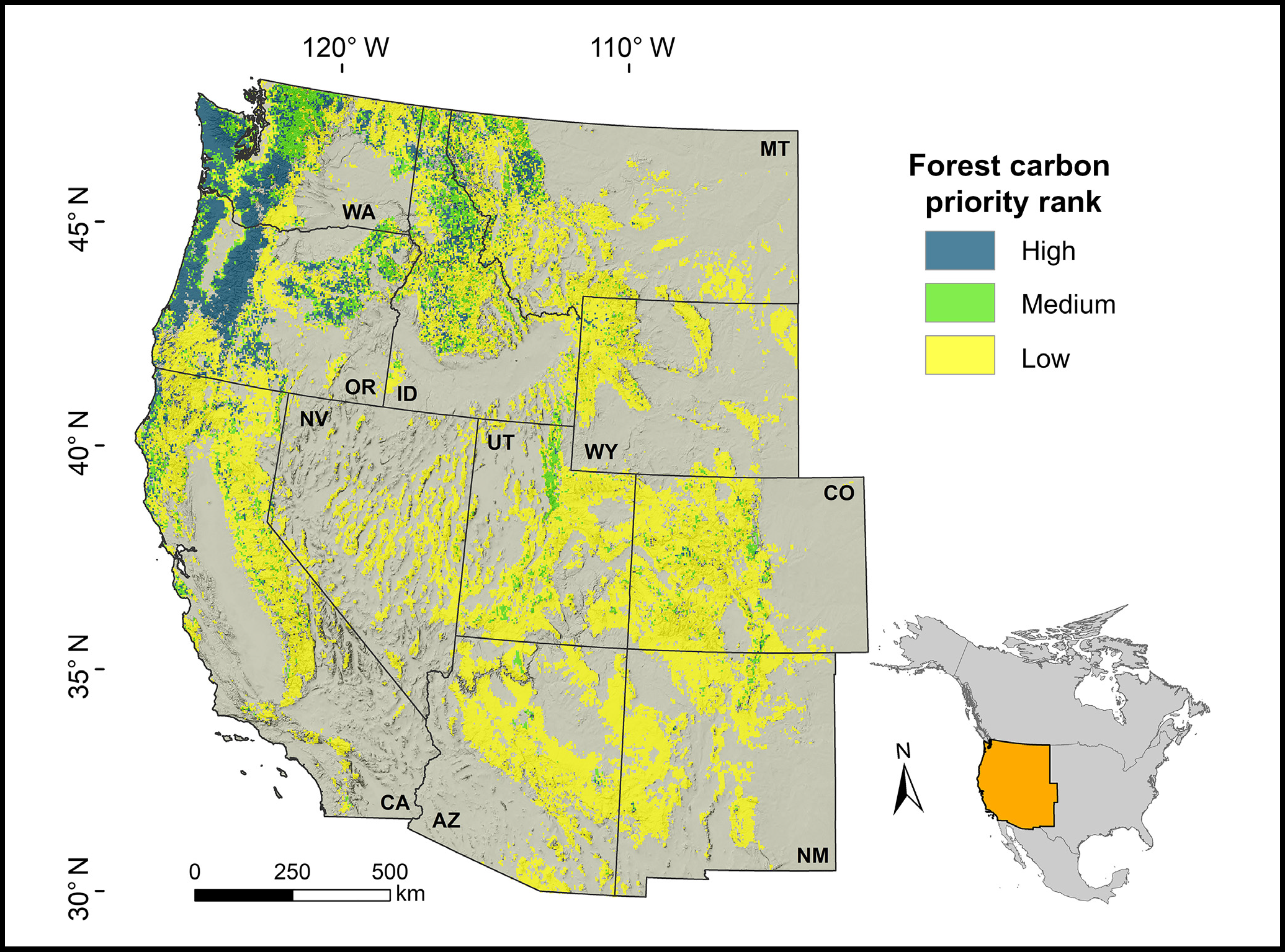
Forest Preservation Ranking and Vertebrate Species Richness, Western USA, 2020-2099
National Aeronautics and Space Administration —
This dataset provides related gridded outputs of future modeled forest carbon sequestration priority and related species richness and habitat suitability for the...
13 datasets found for "Wildlife"