
-
Federal
Pre-LBA ISLSCP Initiative I Data
National Aeronautics and Space Administration —
This data set contains hydrology, soils, radiation, cloud, and vegetation data from the International Satellite Land Surface Climatology Project (ISLSCP) Initiative... -
Federal
LBA-ECO ND-03 Stream and Soil Water Data, Fazenda Nova Vida, Rondonia: 1994-2001
National Aeronautics and Space Administration —
This data set provides the results of (1) the physical and chemical characterization of streams and (2) comparable chemical analyses of extracted soil water in the... -
Federal
LBA-ECO ND-03 Forest and Pasture Watershed Hydrochemistry, Rondonia, Brazil
National Aeronautics and Space Administration —
This data set consists of water chemistry data from streams, wells, rainwater, and canopy throughfall samples. The field measurements were carried out at Rancho... -
Federal
LBA-ECO CD-06 Carbon Cycling in Rivers in Amazonas and Acre, Brazil: 2005-2006
National Aeronautics and Space Administration —
This data set provides measured and calculated variables describing the carbon pools in river waters, CO2 respired from the water and total amount of CO2 evaded,... -
Federal
Pre-Delta-X: Total Suspended Solids of Surface Water across MRD, LA, USA, 2015-2016
National Aeronautics and Space Administration —
This dataset contains the total suspended solids (TSS) concentration of in situ water samples collected at selected sites across the Atchafalaya and Terrebonne Basins... -
Federal
LBA-ECO ND-11 Pre-harvest Forest Tree and Liana Biomass, NW Mato Grosso, Brazil: 2003
National Aeronautics and Space Administration —
The purpose of this study was to determine if spatially-explicit commercial timber inventories (CTI) could be used in conjunction with satellite imagery to improve... -
Federal
LBA-ECO CD-06 Flux of CO2 from Amazon Mainstem Rivers, Tributaries, and Floodplains
National Aeronautics and Space Administration —
This data set provides estimates of monthly carbon dioxide (CO2) flux from the Amazon mainstem rivers, tributary stream networks, and their associated varzeas... -
Federal
LBA-ECO CD-06 Physical, Political, and Hydrologic Maps, Ji-Parana River Basin, Brazil
National Aeronautics and Space Administration —
This data set contains physical, hydrologic, political, demographic, and societal maps for the Ji-Parana River Basin, in the state of Rondonia, Brazil. These data... -
Federal
Stream Flow Storm Data (FIFE)
National Aeronautics and Space Administration —
The Storm Event Stream Flow Data Set were collected during storm events from five treatment areas within the Konza Prairie Long-Term Ecological Research (LTER) site... -
Federal
LBA-ECO ND-01 Watershed Deforestation from Landsat TM Series, Rondonia, Brazil: 1999
National Aeronautics and Space Administration —
This data set provides estimates of watershed deforestation, as a proportion of the total area of watersheds, in Rondonia, Brazil for 1999. Deforestation maps were... -
Federal
LBA Regional River Discharge Data (Coe and Olejniczak)
National Aeronautics and Space Administration —
This data set is a subset of a global river discharge data set by Coe and Olejniczak (1999). The subset was created for the study area of the Large Scale Biosphere-... -
Federal
Pre-Delta-X: L3 AirSWOT-derived Water Level Profiles, Wax Lake Outlet, LA, USA, 2015
National Aeronautics and Space Administration —
This dataset contains water level profiles generated from the AirSWOT data collected in the Atchafalaya Basin in Southern Louisiana, USA, within the Mississippi River... -
Federal
LBA-ECO LC-09 Natural, Infrastructure, and Boundary Features, Amazonian Sites, Brazil
National Aeronautics and Space Administration —
This data set includes 16 zipped archives of shapefiles of cities, rivers and streams, roads, and study area boundaries of several Amazonian study sites: Altamira,... -
Federal
LBA-ECO LC-04 Macrohydrological Routing Data for the Amazon and Tocantins River Basin
National Aeronautics and Space Administration —
This data set provides continental-scale hydrological river flow routing parameter data for the Amazon and Tocantins River basins at 5 minute (~9 km) resolution... -
Federal
LBA Regional Hydrographic Data, 1-Degree, Release 2.2 (Cogley)
National Aeronautics and Space Administration —
This subset of the Global Hydrographic data set (GGHYDRO) Release 2.2 for the study area of the Large Scale Biosphere-Atmosphere Experiment in Amazonia (LBA) in South... -
Federal
Multivariate Time Series Search
National Aeronautics and Space Administration —
Multivariate Time-Series (MTS) are ubiquitous, and are generated in areas as disparate as sensor recordings in aerospace systems, music and video streams, medical... -
Federal
LBA-ECO LC-07 Bathymetric Survey of Floodplain Lake, Lago Curuai, Para, Brazil: 2004
National Aeronautics and Space Administration —
The bathymetry data provided represent a continuous surface of interpolated point measurements of depth values of Lago Curuai, an Amazon River floodplain lake,... -
Federal
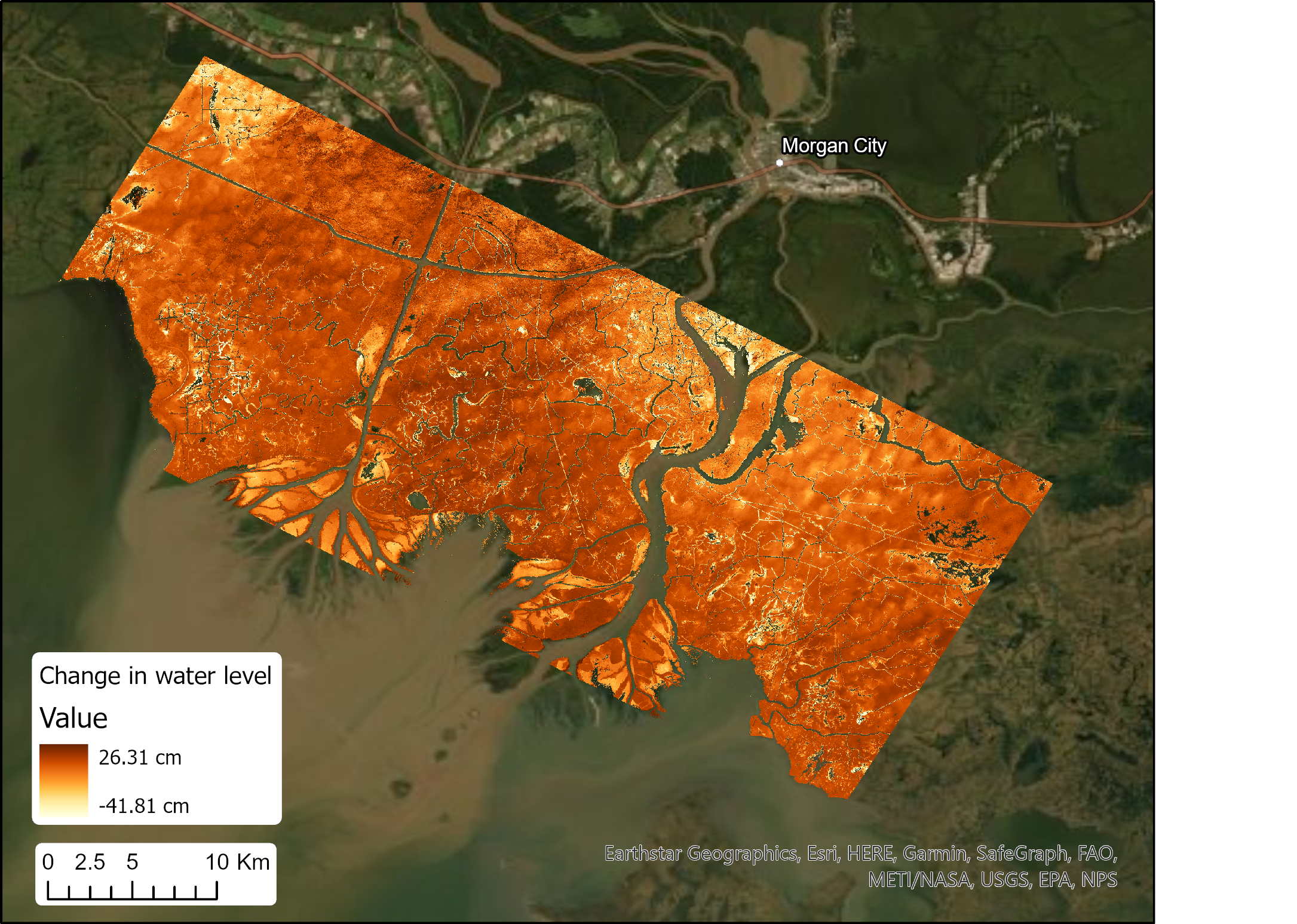
Pre-Delta-X: UAVSAR-derived Water Level Change Maps, Atchafalaya Basin, LA, USA, 2016
National Aeronautics and Space Administration —
This dataset contains five maps of cumulative changes in water levels at 30-minute intervals over a 150-minute period on 2016-10-16 in the Atchafalaya Basin in... -
Federal
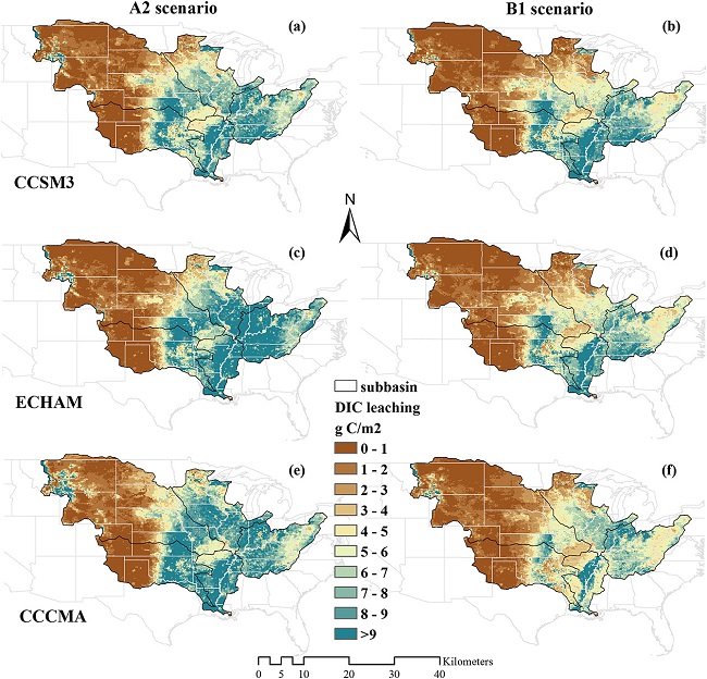
Export and Leaching of Carbon and Nitrogen from Mississippi River Basin, 1901-2099
National Aeronautics and Space Administration —
This dataset provides estimates for export and leaching of dissolved inorganic carbon (DIC), dissolved organic carbon (DIC), total organic carbon (TOC), particulate...

Official websites use .gov
A
.gov website belongs to an official government
organization in the United States.
Secure .gov websites use HTTPS
A
lock (
) or https:// means you’ve safely connected to
the .gov website. Share sensitive information only on official,
secure websites.