
-
Federal
MetOp-C ASCAT Level 2 25.0km Ocean Surface Wind Vectors in Full Orbit Swath
National Aeronautics and Space Administration —
This dataset contains operational near-real-time Level 2 ocean surface wind vector retrievals from the Advanced Scatterometer (ASCAT) on MetOp-C at 25 km sampling... -
Federal
SENTINEL-1A_DUAL_POL_GRD_HIGH_RES
National Aeronautics and Space Administration —
Sentinel-1A Dual-pol ground projected high and full resolution images -
Federal
MetOp-C ASCAT Level 2 Ocean Surface Wind Vectors Optimized for Coastal Ocean
National Aeronautics and Space Administration —
This dataset contains operational near-real-time Level 2 coastal ocean surface wind vector retrievals from the Advanced Scatterometer (ASCAT) on MetOp-C at 12.5 km... -
Federal
SASSIE Arctic Field Campaign Drifter Hydrography Data Fall 2022 Version 2p
National Aeronautics and Space Administration —
The Salinity and Stratification at the Sea Ice Edge (SASSIE) project is a NASA experiment that aims to understand how salinity anomalies in the upper ocean generated... -
Federal
GHRSST Level 3U Global Subskin Sea Surface Temperature version 8a from the Advanced Microwave Scanning Radiometer 2 on the GCOM-W satellite
National Aeronautics and Space Administration —
GDS2 Version -The Advanced Microwave Scanning Radiometer 2 (AMSR2) was launched on 18 May 2012, onboard the Golbal Change Observation Mission - Water (GCOM-W)... -
Federal
CAR FIREACE Arctic Ice and Cloud Radiation BRDF V2 (CAR_FIREACE_BRDF) at GES DISC
National Aeronautics and Space Administration —
The scientific objectives of FIRE/ACE are to study impact of Arctic clouds on radiation exchange between surface, atmosphere, and space, and the influence of surface... -
Federal
JPL SMAP Level 2B Near Real-time CAP Sea Surface Salinity V5.0 Validated Dataset (2 hour latency)
National Aeronautics and Space Administration —
The SMAP-SSS V5.0, level 2B (NRT CAP) dataset produced by the Jet Propulsion Laboratory Combined Active-Passive (CAP) project , is a validated product that provides... -
Federal
GRACE/GRACE-FO Level-4 Monthly Global Ocean Mass Anomaly version 01 from NASA MEaSUREs HOMaGE project
National Aeronautics and Space Administration —
This data set contains the monthly Global Ocean Mass Anomalies (goma) since 04/2002, as measured by the GRACE and GRACE Follow-On (G/GFO) satellite missions. The data... -
Federal
CAR ARMCAS Arctic Cloud Radiation Measurements L1 V1 (CAR_ARMCAS_L1C) at GES DISC
National Aeronautics and Space Administration —
The Arctic Radiation Measurement in Column Atmosphere-surface System (ARMCAS) was a collaborative research effort between the Cloud and Aerosol Research (CAR) Group,... -
Federal
JPL SMAP Level 2B Near Real-time CAP Sea Surface Salinity V5.0 Validated Dataset
National Aeronautics and Space Administration —
This is the PI-produced JPL SMAP-SSS V5.0, level 2B NRT CAP, validated sea surface salinity (SSS) and extreme winds orbital/swath product from the NASA Soil Moisture... -
Federal
Multi-Mission Optimally Interpolated Sea Surface Salinity Global Dataset V2
National Aeronautics and Space Administration —
This is a level 4 product on a 0.25-degree spatial and 4-day temporal grid. The product is derived from the level 2 swath data of three satellite missions: the... -
Federal
GHRSST Level 3C North Atlantic Regional Subskin Sea Surface Temperature from the Advanced Very High Resolution Radiometer (AVHRR) on NOAA-19 (GDS2 version)
National Aeronautics and Space Administration —
A Group for High Resolution Sea Surface Temperature (GHRSST) dataset for the North Atlantic Region (NAR) from the Advanced Very High Resolution Radiometer (AVHRR) on... -
Federal
MetOp-B ASCAT Level 2 Ocean Surface Wind Vectors Optimized for Coastal Ocean
National Aeronautics and Space Administration —
This dataset contains operational near-real-time Level 2 coastal ocean surface wind vector retrievals from the Advanced Scatterometer (ASCAT) on MetOp-B at 12.5 km... -
Federal
MetOp-A ASCAT Level 2 12.5-km Ocean Surface Wind Vector Climate Data Record Optimized for Coastal Ocean
National Aeronautics and Space Administration —
This dataset represents the first historically reprocessed Level 2 coastal ocean surface wind vector climate data record from the Advanced Scatterometer (ASCAT) on... -
Federal
NSCAT Gridded Level 3 Enhanced Resolution Sigma-0 from BYU
National Aeronautics and Space Administration —
This NASA Scatterometer (NSCAT) satellite Sigma-0 dataset is generated by the Scatterometer Climate Record Pathfinder (SCP) project at Brigham Young University (BYU)... -
Federal
Turbulence Models: Data from Other Experiments: Flow Behind a NACA 0012 Wingtip
National Aeronautics and Space Administration —
Exp: Flow Behind a NACA 0012 Wingtip. This web page provides data from experiments that may be useful for the validation of turbulence models. This resource is... -
Federal
GHRSST Level 4 DMI_OI Global Foundation Sea Surface Temperature Analysis (GDS version 2)
National Aeronautics and Space Administration —
A Group for High Resolution Sea Surface Temperature (GHRSST) Level 4 sea surface temperature analysis produced daily on an operational basis by the Danish... -
Federal
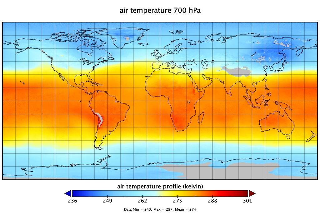
Sounder SIPS: Suomi NPP CrIMSS Level 3 Specific Quality Control Gridded Monthly SiFSAP V2 (SNDRSNIML3SMSFSP) at GES DISC
National Aeronautics and Space Administration —
The SIFSAP (Single Field-of-View Sounder Atmospheric Products) algorithm provides retrieval for each sounder Field of View (FOV), therefore, it has 3-times higher... -
Federal
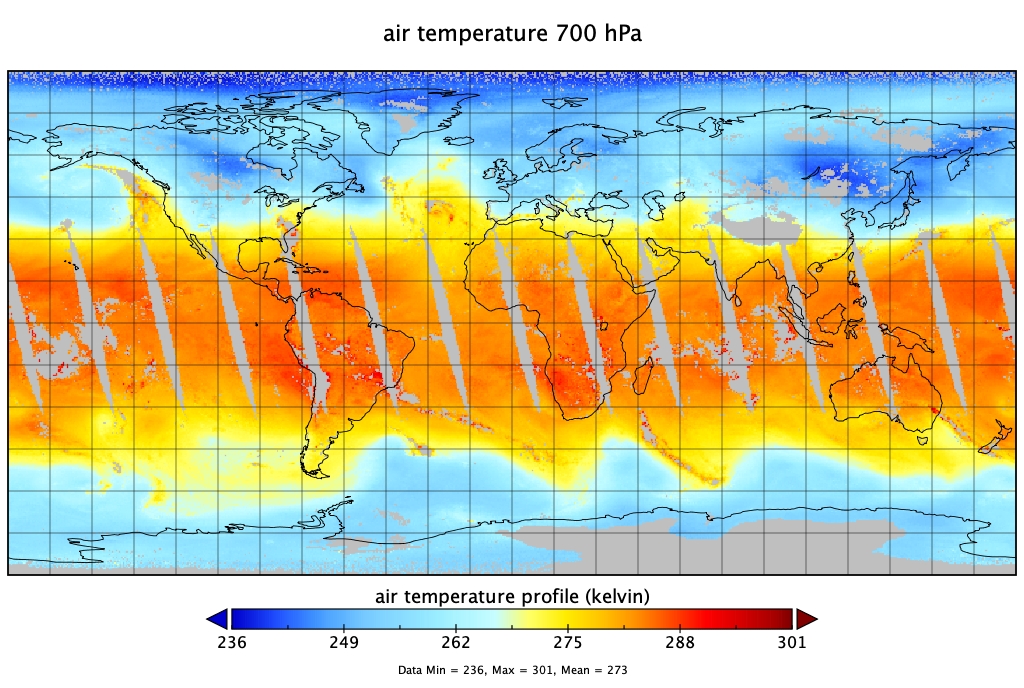
Sounder SIPS: Suomi NPP CrIMSS Level 3 Specific Quality Control Gridded Daily SiFSAP V2 (SNDRSNIML3SDSFSP) at GES DISC
National Aeronautics and Space Administration —
The SIFSAP (Single Field-of-View Sounder Atmospheric Products) algorithm provides retrieval for each sounder Field of View (FOV), therefore, it has 3-times higher...

Official websites use .gov
A
.gov website belongs to an official government
organization in the United States.
Secure .gov websites use HTTPS
A
lock (
) or https:// means you’ve safely connected to
the .gov website. Share sensitive information only on official,
secure websites.