

11 datasets found for "Routes"
-
Federal
The NASA Air Traffic Management Ontology (atmonto)
National Aeronautics and Space Administration —
The NASA ATM (Air Traffic Management) Ontology describes classes, properties, and relationships relevant to the domain of air traffic management, and represents... -
Federal
LBA-ECO LC-04 Macrohydrological Routing Data for the Amazon and Tocantins River Basin
National Aeronautics and Space Administration —
This data set provides continental-scale hydrological river flow routing parameter data for the Amazon and Tocantins River basins at 5 minute (~9 km) resolution... -
Federal
Sea Ice Edge Location and Extent in the Russian Arctic, 1933-2006, Version 1
National Aeronautics and Space Administration —
The Sea Ice Edge Location and Extent in the Russian Arctic, 1933-2006 data are derived from sea ice charts from the Arctic and Antarctic Research Institute (AARI),... -
Federal
Arctic Marine Transportation Program 1979-1986, Version 1
National Aeronautics and Space Administration —
The purpose of this program was to collect data relevant to developing year-round transportation capabilities in the Arctic Ocean. The US Maritime Administration... -
Federal
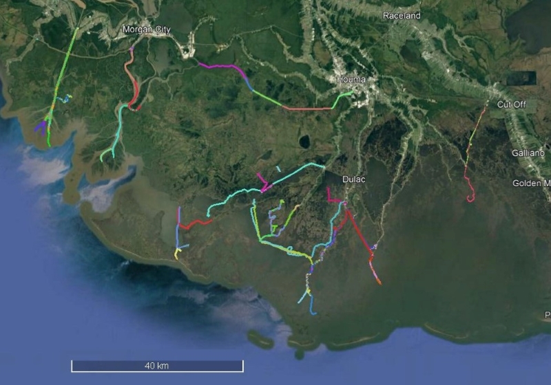
Delta-X: Sonar Bathymetry Survey of Channels, MRD, Louisiana, 2021
National Aeronautics and Space Administration —
This dataset includes bathymetry data for water channels in a portion of the Mississippi River Delta (MRD) of coastal Louisiana. The data were collected using sonar... -
Federal
NARSTO Pacific 2001 Air Quality Study (PAC2001) Slocan Park (SLPK) Slocan Park Site Gaseous, Partculate Matter (PM), and Meteorological Data
National Aeronautics and Space Administration —
NARSTO_PAC2001_SLOCAN_PARK_GAS_PM_MET_DATA is the North American Research Strategy for Tropospheric Ozone (NARSTO) Pacific 2001 Air Quality Study (PAC2001) Slocan... -
Federal
NARSTO PAC2001 Sumas Eagle Ridge Gaseous, Particle, and Meteorological Data
National Aeronautics and Space Administration —
NARSTO_PAC2001_SUMAS_MTN_GAS_PM_MET_DATA was obtained between August 13 and September 5, 2001 during the Pacific 2001 Air Quality Study (PAC2001). Measurements were... -
Federal
ISLSCP II River Routing Data (STN-30p)
National Aeronautics and Space Administration —
The Simulated Topological Network (STN-30p) data set provides the large-scale hydrological modeling community an accurate representation of the global river system at... -
Federal
Sea Ice Charts of the Russian Arctic in Gridded Format, 1933-2006, Version 1
National Aeronautics and Space Administration —
The Arctic and Antarctic Research Institute (AARI) in St. Petersburg, Russia, produces sea ice charts for safety of navigation in the polar regions and for other... -
Federal
ABoVE: Alder Shrub Cover and Soil Properties, Alaska, 2019, V2
National Aeronautics and Space Administration —
This dataset holds measures of vegetative cover and soil characteristics for sites in interior Alaska, U.S., along the James W. Dalton Highway (Alaska Route 11). The... -
Federal
Adaptive response of Arabidopsis seedlings in microgravity and Mars reduced gravity environment is enhanced by red light photostimulation
National Aeronautics and Space Administration —
The response of plants to the spaceflight environment and microgravity is still not well understood although there has been an increased emphasis on this topic. Even...
11 datasets found for "Routes"