
-
Federal
Last of the Wild Project, Version 2, 2005 (LWP-2): Global Human Influence Index (HII) Dataset (Geographic)
National Aeronautics and Space Administration —
The Global Human Influence Index Dataset of the Last of the Wild Project, Version 2, 2005 (LWP-2) is a global dataset of 1-kilometer grid cells, created from nine... -
Federal
Last of the Wild Project, Version 2, 2005 (LWP-2): Global Human Footprint Dataset (Geographic)
National Aeronautics and Space Administration —
The Global Human Footprint Dataset of the Last of the Wild Project, Version 2, 2005 (LWP-2) is the Human Influence Index (HII) normalized by biome and realm. The HII... -
Federal
Last of the Wild Project, Version 1, 2002 (LWP-1): Global Human Footprint Dataset (IGHP)
National Aeronautics and Space Administration —
The Global Human Footprint Dataset of the Last of the Wild Project, Version 1, 2002 (LWP-1) is the Human Influence Index (HII) normalized by biome and realm. The HII... -
Federal
LBA-ECO LC-14 Modeled Deforestation Scenarios, Amazon Basin: 2002-2050
National Aeronautics and Space Administration —
This data set provides the results of the two modeled scenarios for future patterns of deforestation across the Amazon Basin from 2002 to 2050. This larger defined... -
Federal
PSP Solar Wind Electrons Alphas and Protons (SWEAP) SPAN-A Electron Energy Spectra, Level 2 (L2), 1.74 s Data
National Aeronautics and Space Administration —
SPAN-E Level 2 ELectron Energy Spectra Data-------------------------------------------File Naming Format: psp_swp_spa_sf1_L2_32E_YYYYMMDD_v01.cdfThe SF1 product is an... -
Federal
Last of the Wild Project, Version 3 (LWP-3): 2009 Human Footprint, 2018 Release
National Aeronautics and Space Administration —
The 2009 Human Footprint, 2018 Release provides a global map of the cumulative human pressure on the environment in 2009, at a spatial resolution of ~1 km. The human... -
Federal
Active layer thickness and ground temperatures, Svea, Svalbard, Version 1
National Aeronautics and Space Administration —
Snow and soil temperature records for January 1988 - May 1996 are presented. Included are snow depth and weight measurements, snow density (calculated), active layer... -
Federal
Last of the Wild Project, Version 2, 2005 (LWP-2): Global Human Influence Index (HII) Dataset (IGHP)
National Aeronautics and Space Administration —
The Global Human Influence Index Dataset of the Last of the Wild Project, Version 2, 2005 (LWP-2) is a global dataset of 1-kilometer grid cells, created from nine... -
Federal
HLS Landsat Operational Land Imager Surface Reflectance and TOA Brightness Daily Global 30m v2.0
National Aeronautics and Space Administration —
The Harmonized Landsat Sentinel-2 (HLS) project provides consistent surface reflectance (SR) and top of atmosphere (TOA) brightness data from a virtual constellation... -
Federal
LBA-ECO CD-06 Physical, Political, and Hydrologic Maps, Ji-Parana River Basin, Brazil
National Aeronautics and Space Administration —
This data set contains physical, hydrologic, political, demographic, and societal maps for the Ji-Parana River Basin, in the state of Rondonia, Brazil. These data... -
Federal
NARSTO PAC2001 Langley Site Gaseous, Particle, and Meteorological Data
National Aeronautics and Space Administration —
NARSTO_PAC2001_LANGLEY_GAS_PM_MET_DATA was obtained between August 8 and September 2, 2001 during the Pacific 2001 Air Quality Study (PAC2001).The Langley Ecole... -
Federal
BOREAS TGB-03 CH4 and CO2 Chamber Flux Data over NSA Upland Sites
National Aeronautics and Space Administration —
The BOREAS TGB-03 team collected methane and carbon dioxide (CH4, CO2) chamber flux measurements at the NSA Fen site, OBS, YJP, and auxiliary sites along Gillam Road... -
Federal
PSP Solar Wind Electrons Alphas and Protons (SWEAP) SPAN-B Electron Energy Spectra, Level 2 (L2), 1.74 s Data
National Aeronautics and Space Administration —
SPAN-E Level 2 ELectron Energy Spectra Data-------------------------------------------File Naming Format: psp_swp_spb_sf1_L2_32E_YYYYMMDD_v01.cdfThe SF1 product is an... -
Federal
LBA-ECO LC-13 GIS Coverages of Logged Areas, Cauaxi, Para, Brazil: 1996, 1998
National Aeronautics and Space Administration —
We combined a detailed field study of canopy gap fraction with spectral mixture analysis of Landsat ETM+ satellite imagery to assess landscape and regional dynamics... -
Federal
LBA-ECO LC-13 GIS Coverages of Logged Areas, Tapajos Forest, Para, Brazil: 1996, 1998
National Aeronautics and Space Administration —
We combined a detailed field study of canopy gap fraction with spectral mixture analysis of Landsat ETM+ satellite imagery to assess landscape and regional dynamics... -
Federal
West Africa Coastal Vulnerability Mapping: Subset of JRC Map of Accessibility
National Aeronautics and Space Administration —
The West Africa Coastal Vulnerability Mapping: Subset of JRC Map of Accessibility data set is a 30 arc-second raster of travel time to major cities in West Africa... -
Federal
PSP Solar Wind Electrons Alphas and Protons (SWEAP) SPAN-B Full 3D Electron Spectra, Level 2 (L2), 14 s Data
National Aeronautics and Space Administration —
SPAN-E Level 2 Electron Full 3D Spectra Data--------------------------------------------File Naming Format: psp_swp_spb_sf0_L2_16Ax8Dx32E_YYYYMMDD_v01.cdfThe SF0... -
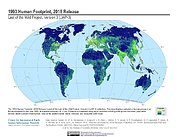
Federal
Last of the Wild Project, Version 3 (LWP-3): 1993 Human Footprint, 2018 Release
National Aeronautics and Space Administration —
The 1993 Human Footprint, 2018 Release provides a global map of the cumulative human pressure on the environment in 1993, at a spatial resolution of ~1 km. The human... -
Federal
PSP Solar Wind Electrons Alphas and Protons (SWEAP) SPAN-A Full 3D Electron Spectra, Level 2 (L2), 14 s Data
National Aeronautics and Space Administration —
SPAN-E Level 2 Electron Full 3D Spectra Data--------------------------------------------File Naming Format: psp_swp_spa_sf0_L2_16Ax8Dx32E_YYYYMMDD_v01.cdfThe SF0... -
Federal
LBA-ECO LC-03 Hypsography, Rivers, Roads, and DEM, Four Areas across Brazilian Amazon
National Aeronautics and Space Administration —
This data set provides four related spatial data products for four study areas across the Brazilian Amazon: Manaus, Amazonas; Tapajos National Forest, Para Western...

Official websites use .gov
A
.gov website belongs to an official government
organization in the United States.
Secure .gov websites use HTTPS
A
lock (
) or https:// means you’ve safely connected to
the .gov website. Share sensitive information only on official,
secure websites.