
-
Federal
Shuttle Radar Topography Mission 1-arc second Global
National Aeronautics and Space Administration —
The Shuttle Radar Topography Mission (SRTM) was flown aboard the space shuttle Endeavour February 11-22, 2000. The National Aeronautics and Space Administration... -
Federal
ASTER Global Digital Elevation Model V003
National Aeronautics and Space Administration —
The Terra Advanced Spaceborne Thermal Emission and Reflection Radiometer (ASTER) Global Digital Elevation Model (GDEM) Version 3 (ASTGTM) provides a global digital... -
Federal
Non-targeted effects of low dose ionizing radiation act via TGF-beta to promote mammary carcinogenesis
National Aeronautics and Space Administration —
This is a genome-wide approach to identifying genes persistently induced in the mouse mammary gland by acute whole body low dose ionizing radiation (10cGy) 1 and 4... -
Federal
Global Multi-resolution Terrain Elevation Data 2010 (GMTED2010)
National Aeronautics and Space Administration —
The USGS and the NGA have collaborated on the development of a notably enhanced global elevation model named the GMTED2010 that replaces GTOPO30 as the elevation... -
Federal
ASTER Global Digital Elevation Model NetCDF V003
National Aeronautics and Space Administration —
The Terra Advanced Spaceborne Thermal Emission and Reflection Radiometer (ASTER) Global Digital Elevation Model (GDEM) Version 3 (ASTGTM) provides a global digital... -
Federal
MODIS/Terra+Aqua Land Cover Type Yearly L3 Global 500m SIN Grid V006
National Aeronautics and Space Administration —
The MCD12Q1 Version 6 data product was decommissioned on July 31, 2023. Users are encouraged to use the MCD12Q1... -
Federal
Distribution of Estimated Stand Age Across Siberian Larch Forests, 1989-2012
National Aeronautics and Space Administration —
This data set provides mapped estimates of the stand age of young (less than 25 years old) larch forests across Siberia from 1989-2012 at 30-m resolution. The age... -
Federal
Navigation and Ancillary Information Facility's SPICE
National Aeronautics and Space Administration —
The Navigation and Ancillary Information Facility (NAIF), acting under the directions of NASA's Planetary Science Division, has built an information system named... -
Federal
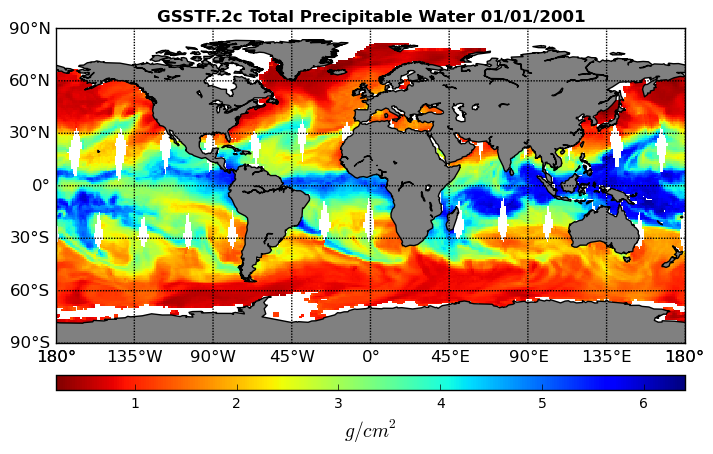
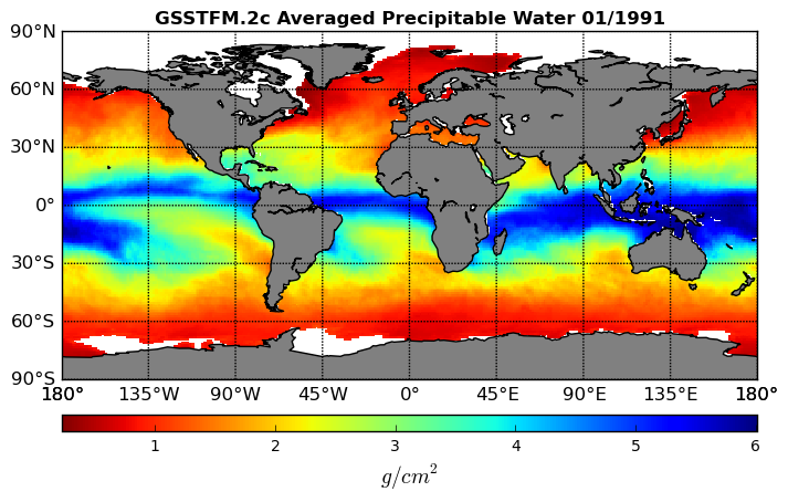
Goddard Satellite-Based Surface Turbulent Fluxes, 1x1 deg Monthly Climatology, Set1 and NCEP V2c (GSSTFMC) at GES DISC
National Aeronautics and Space Administration —
These data are the Goddard Satellite-based Surface Turbulent Fluxes Version-2c Dataset recently produced through a MEaSURES funded project led by Dr. Chung-Lin Shie... -
Federal
ASTER Global Digital Elevation Model V002
National Aeronautics and Space Administration —
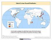
The ASTGTM.002 dataset was decommissioned as of August 5, 2019. Users are encouraged to use the new improvedFederalGlobal Cyclone Hazard Frequency and Distribution
National Aeronautics and Space Administration —
The Global Cyclone Hazard Frequency and Distribution is a 2.5 minute grid based on more than 1,600 storm tracks for the period 1 January 1980 through 31 December 2000...FederalASTER Global Digital Elevation Model Attributes NetCDF V003
National Aeronautics and Space Administration —
The Terra Advanced Spaceborne Thermal Emission and Reflection Radiometer (ASTER) Global Digital Elevation Model (GDEM) Version 3 (ASTGTM) provides a global digital...FederalNon-targeted effects of low dose ionizing radiation act via TGF-beta to promote mammary carcinogenesis
National Aeronautics and Space Administration —
This is a genome-wide approach to identifying genes persistently induced in the mouse mammary gland by acute whole body low dose ionizing radiation (10cGy) 1 and 4...FederalPre-LBA Anglo-Brazilian Amazonian Climate Observation Study (ABRACOS) Data
National Aeronautics and Space Administration —
The data set presents the principal data from the Anglo-BRazilian Amazonian Climate Observation Study (ABRACOS) (Gash et al, 1996) and provides quality controlled...FederalGRIP DC-8 METEOROLOGICAL MEASUREMENT SYSTEM (MMS) V1
National Aeronautics and Space Administration —
The GRIP DC-8 Meteorological measurement System (MMS) dataset was collected by the Meteorological Measurement System (MMS), which provides high-resolution, accurate...FederalGoddard Satellite-Based Surface Turbulent Fluxes, 1x1 deg Daily Grid, Set1 V2c (GSSTF) at GES DISC
National Aeronautics and Space Administration —
These data are the Goddard Satellite-based Surface Turbulent Fluxes Version-2c (GSSTF2c) Dataset recently produced through a MEaSUREs funded project led by Dr. Chung-...FederalGoddard Satellite-Based Surface Turbulent Fluxes, 1x1 deg Monthly Grid, Set1 and Interpolated Data V2c (GSSTFM) at GES DISC
National Aeronautics and Space Administration —
These data are the Goddard Satellite-based Surface Turbulent Fluxes Version-2c Dataset recently produced through a MEaSUREs funded project led by Dr. Chung-Lin Shie...FederalGoddard Satellite-Based Surface Turbulent Fluxes, 1x1 deg Yearly Climatology, Set1 and NCEP V2c (GSSTFYC) at GES DISC
National Aeronautics and Space Administration —
These data are the Goddard Satellite-based Surface Turbulent Fluxes Version-2c Dataset recently produced through a MEaSURES funded project led by Dr. Chung-Lin Shie...FederalGround-Based Global Navigation Satellite System (GNSS)-based Upper Atmospheric Realtime Disaster Information and Alert Network (GUARDIAN) Near Real-Time Ionospheric Total Electron Count (5-second sampling, 24-hour files) from NASA CDDIS
National Aeronautics and Space Administration —
Developed at JPL, GUARDIAN is a near-real-time (NRT) ionospheric monitoring software (Martire et al.). Its main products are NRT total electronic content (TEC) time...FederalLBA-ECO CD-04 LAI Estimated from Photos, km 83 Tower Site, Tapajos National Forest
National Aeronautics and Space Administration —
This data set contains summary data for monthly leaf area index (LAI) and plant area index (PAI) at the km 83 Tower Site, in the Tapajos National Forest, Para,...22 datasets found for "Post-larval Development"

Official websites use .gov
A
.gov website belongs to an official government
organization in the United States.
Secure .gov websites use HTTPS
A
lock (
) or https:// means you’ve safely connected to
the .gov website. Share sensitive information only on official,
secure websites.