
-
Federal
LBA-ECO LC-01 SRTM 90-Meter Digital Elevation Model, Northern Ecuadorian Amazon
National Aeronautics and Space Administration —
This data set provides 90-meter resolution Digital Elevation Model data used in the University of North Carolina's Carolina Population Center (CPC) Ecuador Projects.... -
Federal
GPM Ground Validation Duke Soil Moisture IPHEx
National Aeronautics and Space Administration —
The GPM Ground Validation Duke Soil Moisture dataset consists of a collection of various data obtained during the Integrated Precipitation and Hydrology Experiment... -
Federal
GPM Ground Validation NASA ER-2 Navigation Data IPHEx V1
National Aeronautics and Space Administration —
The GPM Ground Validation NASA ER-2 Navigation Data IPHEx dataset was gathered during the GPM Ground Validation Integrated Precipitation and Hydrology Experiment... -
Federal
GPM Ground Validation NOAA X-band Polarimetric Radar (NOXP) IPHEx V1
National Aeronautics and Space Administration —
The GPM Ground Validation NOAA X-band dual-Polarimetric radar (NOXP) IPHEx dataset consists of differential reflectivity, differential phase shift, co-polar cross... -
Federal
GPM Ground Validation NASA S-Band Dual Polarimetric (NPOL) Doppler Radar IPHEx
National Aeronautics and Space Administration —
The GPM Ground Validation NASA S-Band Dual Polarimetric (NPOL) Doppler Radar IPHEx dataset was collected during the GPM Ground Validation Integrated Precipitation and... -
Federal
GPM Ground Validation Duke Microwave Radiometer (MWR) IPHEx
National Aeronautics and Space Administration —
The GPM Ground Validation Duke Microwave Radiometer (MWR) IPHEx dataset consists of data collected by the MWR, which is a sensitive microwave radiometer that detects... -
Federal
GPM GROUND VALIDATION MICRO RAIN RADAR (MRR) NASA IPHEX V1
National Aeronautics and Space Administration —
The GPM Ground Validation NASA Micro Rain Radar (MRR) is a vertically pointing Doppler radar which provided measurements of vertical velocity, drop size distribution,... -
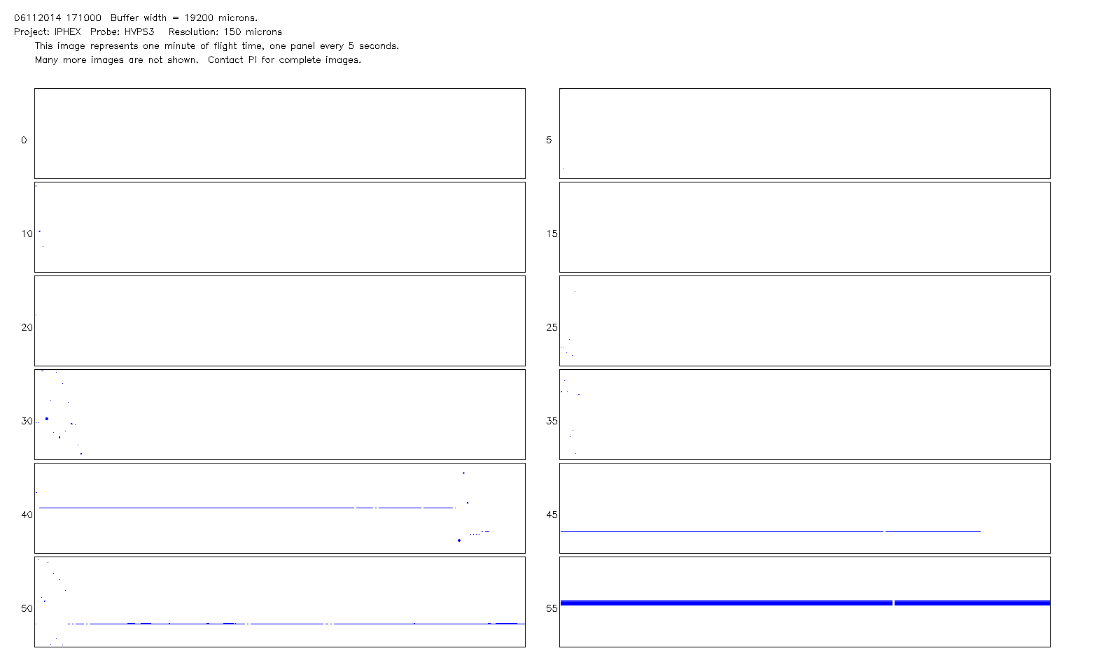
Federal
GPM GROUND VALIDATION HIGH ALTITUDE IMAGING WIND AND RAIN AIRBORNE PROFILER (HIWRAP) IPHEX V1
National Aeronautics and Space Administration —
The GPM Ground Validation High-Altitude Imaging Wind and Rain Airborne Profiler (HIWRAP) IPHEx dataset was collected during the Global Precipitation Measurement (GPM)... -
Federal
GPM Ground Validation Reference Precipitation IPHEx V1
National Aeronautics and Space Administration —
The GPM Ground Validation Reference Precipitation IPHEx dataset consists of 10 years (December 31, 2007-December 31, 2017) of hourly rainfall intensity at 1 km2... -
Federal
GPM Ground Validation Lightning Instrument Package (LIP) IPHEx V1
National Aeronautics and Space Administration —
The GPM Ground Validation Lightning Instrument Package (LIP) IPHEx dataset consists of electrical field measurements of lightning and navigation data collected by the... -
Federal
NARSTO_SOS_SC_UPSTATE PM2.5 Composition Data
National Aeronautics and Space Administration —
The NARSTO_SOS_SC_UPSTATE_PM25_COMPOSITION data were collected during July 2001 and January of 2002 to elucidate the seasonal variability of the aerosols. Samples... -
Federal
GPM Ground Validation NCAR Particle Probes IPHEx V1
National Aeronautics and Space Administration —
The GPM Ground Validation NCAR Particle Probes IPHEx dataset consists of Ice Water Content (IWC), particle number concentration normalized by bin width, and total... -
Federal
GPM Ground Validation National Mosaic and Multi-Sensor QPE (NMQ) System IPHEx V1
National Aeronautics and Space Administration —
The GPM Ground Validation National Mosaic and Multi-Sensor QPE (NMQ) System IPHEx dataset consists of six different data products: precipitation rate, hourly rainfall... -
Federal
GPM Ground Validation Duke Soil Moisture IPHEx V1
National Aeronautics and Space Administration —
The GPM Ground Validation Duke Soil Moisture dataset consists of a collection of various data obtained during the Integrated Precipitation and Hydrology Experiment... -
Federal
GPM Ground Validation Duke Microwave Radiometer (MWR) IPHEx V1
National Aeronautics and Space Administration —
The GPM Ground Validation Duke Microwave Radiometer (MWR) IPHEx dataset consists of data collected by the MWR, which is a sensitive microwave radiometer that detects... -
Federal
LBA-ECO LC-01 Topographic Data for Intensive Study Areas, Northern Ecuadorian Amazon
National Aeronautics and Space Administration —
This data set contains topographic/geomorphological data associated with the four Intensive Study Areas (ISAs) in the Northern Ecuadorian Amazon (northern Oriente)... -
Federal
LBA-ECO LC-01 Landsat TM Land Use/Land Cover, Northern Ecuadorian Amazon: 1986-1999
National Aeronautics and Space Administration —
This data set contains Landsat TM imagery for the years 1986, 1989, 1996, and 1999, that have been classified into four land use/land cover (LULC) classes: Forest,... -
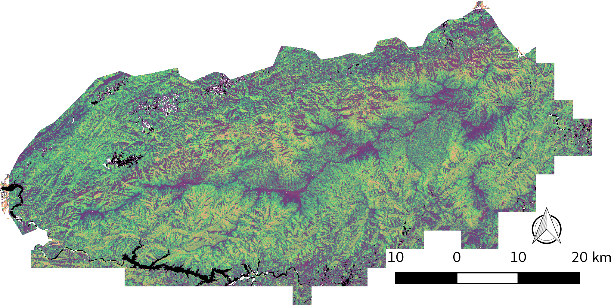
Federal
LiDAR-derived Vegetation Canopy Structure, Great Smoky Mountains National Park, 2011
National Aeronautics and Space Administration —
This dataset provides multiple-return LiDAR-derived vegetation canopy structure at 30-meter spatial resolution for the Great Smoky Mountains National Park (GSMNP).... -
Federal
GPM GROUND VALIDATION CONICAL SCANNING MILLIMETER-WAVE IMAGING RADIOMETER (COSMIR) IPHEx
National Aeronautics and Space Administration —
The GPM Ground Validation Conical Scanning Millimeter-wave Imaging Radiometer (CoSMIR) IPHEx dataset consists of brightness temperatures from 9 channels as measured...

Official websites use .gov
A
.gov website belongs to an official government
organization in the United States.
Secure .gov websites use HTTPS
A
lock (
) or https:// means you’ve safely connected to
the .gov website. Share sensitive information only on official,
secure websites.