
-
Federal
AIRSAR_TOPSAR_DEM
National Aeronautics and Space Administration —
AIRSAR topographic SAR digital elevation model product -
Federal
AIRSAR_TOPSAR_C-BAND_DEM_AND_STOKES
National Aeronautics and Space Administration —
AIRSAR topographic SAR digital elevation model C_Stokes product -
Federal
Pyrocumulonimbus Events over British Columbia in August 2017: Results from the NASA GEOS Earth System Model
National Aeronautics and Space Administration —
Model data associated with the manuscript submitted in Atmospheric Chemistry and Physics Journal, titled, " Pyrocumulonimbus Events over British Columbia in 2017: The... -
Federal
UAVSAR_POLSAR_SLOPE
National Aeronautics and Space Administration —
UAVSAR PolSAR Scene Slope -
Federal
UAVSAR_INSAR_KMZ
National Aeronautics and Space Administration —
UAVSAR Repeat Pass Interferometry Scene KMZ -
Federal
UAVSAR_INSAR_METADATA
National Aeronautics and Space Administration —
UAVSAR Repeat Pass Interferometry Scene Metadata -
Federal
UAVSAR_POLSAR_INCIDENCE
National Aeronautics and Space Administration —
UAVSAR PolSAR Scene Incidence Angle -
Federal
UAVSAR_INSAR_DEM
National Aeronautics and Space Administration —
UAVSAR Repeat Pass Interferometry Scene DEM TIFF -
Federal
UAVSAR_POLSAR_METADATA
National Aeronautics and Space Administration —
UAVSAR PolSAR Scene Metadata -
Federal
UAVSAR_INSAR_INTERFEROGRAM
National Aeronautics and Space Administration —
UAVSAR Repeat Pass Interferometry Scene -
Federal
CMS: Forest Biomass and Productivity, 1-degree and 5-km, Conterminous US, 2005
National Aeronautics and Space Administration —
Notice: This data set and guide were updated on June 30, 2014 to correct an error in the reported units. The data values were not changed.Spatially-gridded estimates... -
Federal
UAVSAR_POLSAR_ML_COMPLEX_SLANT
National Aeronautics and Space Administration —
UAVSAR PolSAR Scene Complex -
Federal
AIRSAR_TOPSAR_DEM_C
National Aeronautics and Space Administration —
AIRSAR topographic SAR digital elevation model CTIF product -
Federal
NCSU Soundings IMPACTS
National Aeronautics and Space Administration —
The NCSU Soundings IMPACTS dataset consists of atmospheric-sounding data collected by the North Carolina State University student sounding club. These data include... -
Federal
STARDUST NAVCAM EARLY CRUISE IMAGES
National Aeronautics and Space Administration —
This volume contains the results of the early cruise images of the Stardust Navigation Camera. These images are of no clear scientific or engineering use. They were... -
Federal
AIRSAR_TOPSAR_L-BAND_STOKES
National Aeronautics and Space Administration —
AIRSAR topographic SAR digital elevation model L_Stokes product -
Federal
VEMAP 2: U.S. Monthly Climate, 1895-1993, Version 2
National Aeronautics and Space Administration —
The Vegetation/Ecosystem Modeling and Analysis Project (VEMAP) Phase 2 has developed a data set of ~100-year gridded monthly and daily time series of climate for the... -
Federal
NARSTO EPA Supersite (SS) Pittsburgh Meteorological Data
National Aeronautics and Space Administration —
NARSTO_EPA_SS_PITTSBURGH_MET_DATA is the North American Research Strategy for Tropospheric Ozone (NARSTO) Environmental Protection Agency (EPA) Supersite (SS)... -
Federal
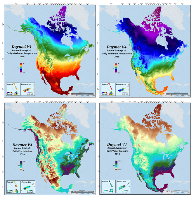
Daymet: Annual Climate Summaries on a 1-km Grid for North America, Version 4 R1
National Aeronautics and Space Administration —
This dataset provides annual climate summaries derived from Daymet Version 4 R1 daily data at a 1 km x 1 km spatial resolution for five Daymet variables: minimum and...

Official websites use .gov
A
.gov website belongs to an official government
organization in the United States.
Secure .gov websites use HTTPS
A
lock (
) or https:// means you’ve safely connected to
the .gov website. Share sensitive information only on official,
secure websites.