
-
Federal
China Dimensions Data Collection: China Administrative Regions GIS Data: 1:1M, County Level, 1990
National Aeronautics and Space Administration —
The China Administrative Regions GIS Data: 1:1M, County Level, 1990 consists of geographic boundary data for the administrative regions of China as of 31 December... -
Federal
International Ice Patrol (IIP) Iceberg Sightings Database, Version 1
National Aeronautics and Space Administration —
The International Ice Patrol (IIP) has been collecting information on iceberg activity in the North Atlantic since 1913. This database contains the data from these... -
Federal
China Dimensions Data Collection: GuoBiao (GB) Codes for the Administrative Divisions of the Peoples Republic of China
National Aeronautics and Space Administration —
The GuoBiao (GB) Codes for the Administrative Divisions of the People's Republic of China consists of geographic codes for the administrative divisions of China. The... -
Federal
EMIT L2B Estimated Mineral Identification and Band Depth and Uncertainty 60 m V001
National Aeronautics and Space Administration —
The Earth Surface Mineral Dust Source Investigation (EMIT) instrument measures surface mineralogy, targeting the Earth’s arid dust source regions. EMIT is installed... -
Federal
China Dimensions Data Collection: China Maps Bibliographic Database
National Aeronautics and Space Administration —
The China Maps Bibliographic Database is an historical collection of bibliographic information for more than 400 maps of China. The information resides in a... -
Federal
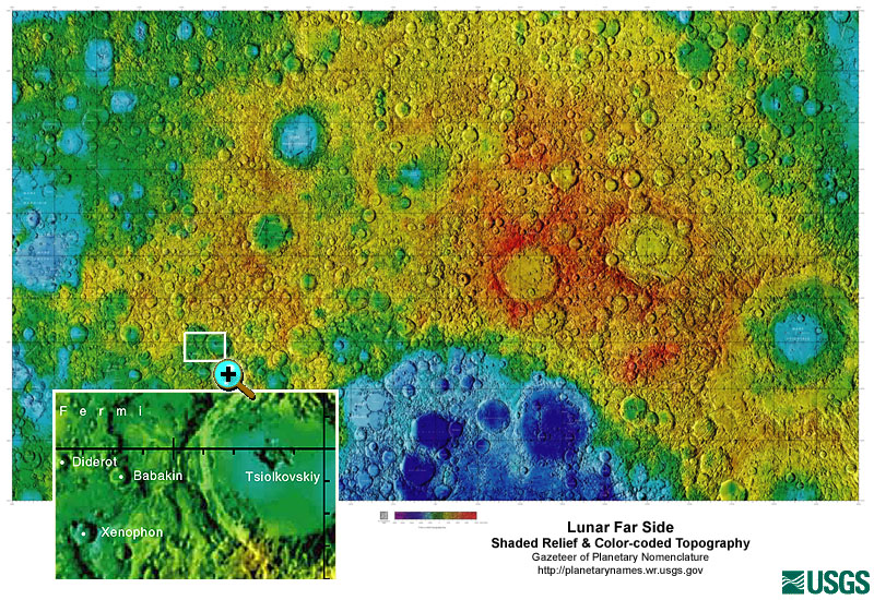
Gazetteer of Planetary Nomenclature: Moon: 1:10 million-scale Shaded Relief and Color-coded Topography: Far Side
National Aeronautics and Space Administration —
These lunar maps display the four different areas of the moon with color-coded topography in low and high resolution approved by the International Astronomical Union... -
Federal
Compendium of Environmental Sustainability Indicator Collections: Ancillary Data
National Aeronautics and Space Administration —
The Ancillary Data portion of the Compendium of Environmental Sustainability Indicator Collections contains 38 variables (time series data on population and gross... -
Federal
International Satellite Cloud Climatology Project (ISCCP) Ice Snow Product in Native Data Format
National Aeronautics and Space Administration —
ISCCP_ICESNOW_NAT_1 is the International Satellite Cloud Climatology Project (ISCCP) Ice Snow Product in Native Data Format data set. It is a merged product... -
Federal
Archive of Census Related Products (ACRP): 1990 Census Block Statistics
National Aeronautics and Space Administration —
The 1990 Census Block Statistics portion of the Archive of Census Related Products (ACRP) contains population and housing data from the U.S. Census Bureau's 1990... -
Federal
International Satellite Cloud Climatology Project (ISCCP) TOVS in Native Data Format
National Aeronautics and Space Administration —
ISCCP_TOVS_NAT_1 is the International Satellite Cloud Climatology Project (ISCCP) TIROS Operational Vertical Sounder (TOVS) data set in the Native Data Format. It is... -
Federal
Global Navigation Satellite System (GNSS) IGS Predicted Ionosphere Vertical Total Electron Content (VTEC) Grid Product from NASA CDDIS
National Aeronautics and Space Administration —
This derived product set consists of Global Navigation Satellite System Predicted Ionosphere Vertical Total Electron Content (VTEC) product (daily files) from the... -
Federal
China Dimensions Data Collection: China Administrative Regions GIS Data: 1:1M, County Level, 1 July 1990
National Aeronautics and Space Administration —
The China Administrative Regions GIS Data: 1:1M, County Level, 1 July 1990 consists of geographic boundary data for the administrative regions of China as of 1 July... -
Federal
Level 2.0 Almucantar Inversion Products Phase Functions
National Aeronautics and Space Administration —
AERONET inversion code provides aerosoloptical properties in the total atmospheric column derived from the direct and diffuse radiation measured byAERONETCimel... -
Federal
Gene expression profiling for spaceflight induced-neuroinflammation in the mouse brain
National Aeronautics and Space Administration —
The health risk from spaceflight-induced neuronal damage and potential adverse neurovascular effects is a chief concern. More recently, it has been proposed that... -
Federal
College (CIGO) Ground-based Vector Magnetic Field (L2) 0.5 s Data
National Aeronautics and Space Administration —
College (College International Geophysical Observatory), AK, Ground-based Vector Magnetic Field Level 2 Data, 0.5 s Time Resolution, Station Code: (CIGO), Station... -
Federal
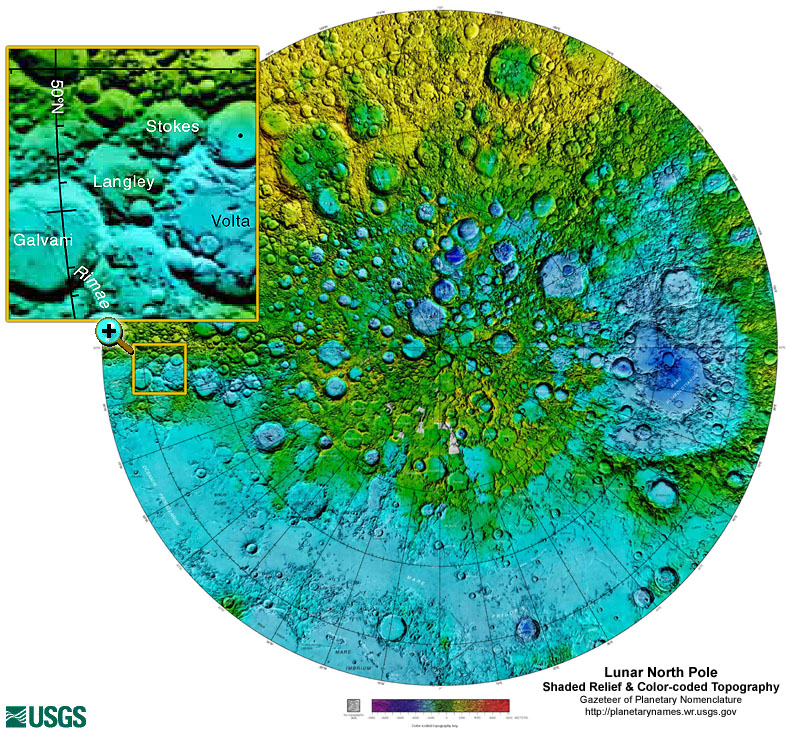
Gazetteer of Planetary Nomenclature: Moon: 1:10 million-scale Shaded Relief and Color-coded Topography: North Pole
National Aeronautics and Space Administration —
These lunar maps display the four different areas of the moon with color-coded topography in low and high resolution approved by the International Astronomical Union... -
Federal
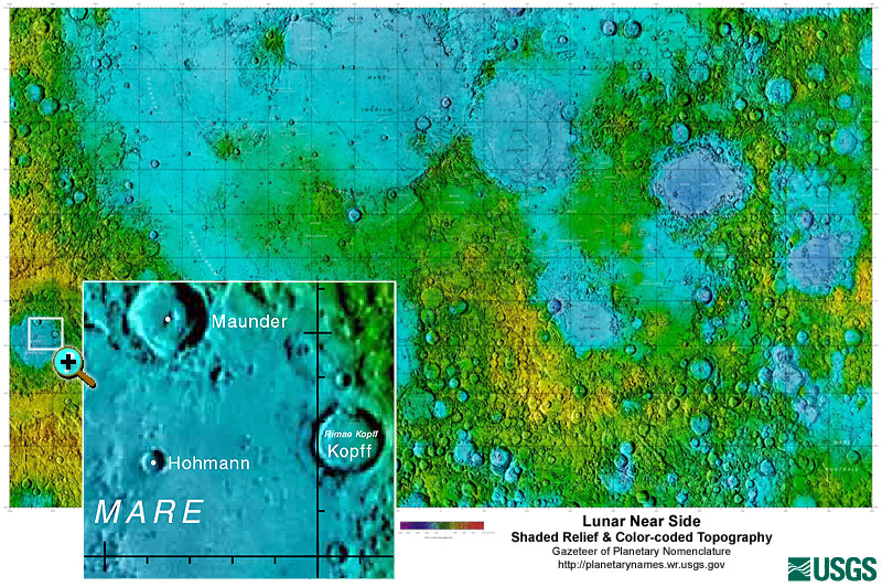
Gazetteer of Planetary Nomenclature: Moon: 1:10 million-scale Shaded Relief and Color-coded Topography: Near Side
National Aeronautics and Space Administration —
These lunar maps display the four different areas of the moon with color-coded topography in low and high resolution approved by the International Astronomical Union... -
Federal
ASTER L2 Surface Radiance TIR V004
National Aeronautics and Space Administration —
The Terra Advanced Spaceborne Thermal Emission and Reflection Radiometer (ASTER) Surface Radiance TIR (AST_09T) is generated using the five Thermal Infrared (TIR)... -
Federal
ARC Code TI: ROC Curve Code Augmentation
National Aeronautics and Space Administration —
ROC (Receiver Operating Characteristic) curve Code Augmentation was written by Rodney Martin and John Stutz at NASA Ames Research Center and is a modification of ROC... -
Federal
Global Navigation Satellite System (GNSS) IGS Weekly Ionosphere Vertical Total Electron Content (VTEC) Grid Validation Product from NASA CDDIS
National Aeronautics and Space Administration —
This derived product set consists of Global Navigation Satellite System Ionosphere Vertical Total Electron Content (VTEC) comparison product (daily files) from the...

Official websites use .gov
A
.gov website belongs to an official government
organization in the United States.
Secure .gov websites use HTTPS
A
lock (
) or https:// means you’ve safely connected to
the .gov website. Share sensitive information only on official,
secure websites.