
-
Federal
MODIS/Terra+Aqua Land Cover Type Yearly L3 Global 500m SIN Grid V061
National Aeronautics and Space Administration —
The Terra and Aqua combined Moderate Resolution Imaging Spectroradiometer (MODIS) Land Cover Type (MCD12Q1) Version 6.1 data product provides global land cover types... -
Federal
LBA Regional Carbon in Live Vegetation, 0.5-degree (Olson)
National Aeronautics and Space Administration —
This data set is a subset of Olson et al. (1985, 2000) "Major World Ecosystem Complexes Ranked by Carbon in Live Vegetation." This subset was created for the study... -
Federal
GPM Ground Validation KHTX NEXRAD IPHEx V1
National Aeronautics and Space Administration —
The GPM Ground Validation KHTX NEXRAD IPHEx datasets contain data from the KHTX NEXt Generation Weather RADar system (NEXRAD) instrument in operation during the... -
Federal
Global Soil Types, 1-Degree Grid (Zobler)
National Aeronautics and Space Administration —
A global data set of soil types is available at 1-degree latitude by 1-degree longitude resolution. There are 26 soil units based on Zobler?s assessment of FAO Soil... -
Federal
LBA Regional Derived Soil Properties, 0.5-Deg (ISRIC-WISE)
National Aeronautics and Space Administration —
The data set consists of a subset of the ISRIC-WISE global data set of derived soil properties for the study area of the Large Scale Biosphere-Atmosphere Experiment... -
Federal
GPM Ground Validation KMRX NEXRAD IPHEx V1
National Aeronautics and Space Administration —
The GPM Ground Validation KMRX NEXRAD IPHEx dataset contain data from the KMRX NEXt Generation Weather RADar system (NEXRAD) instrument in operation during the... -
Federal
LBA Regional River Discharge Data (Coe and Olejniczak)
National Aeronautics and Space Administration —
This data set is a subset of a global river discharge data set by Coe and Olejniczak (1999). The subset was created for the study area of the Large Scale Biosphere-... -
Federal
Stream Flow Storm Data (FIFE)
National Aeronautics and Space Administration —
The Storm Event Stream Flow Data Set were collected during storm events from five treatment areas within the Konza Prairie Long-Term Ecological Research (LTER) site... -
Federal
Wetland Salinity Maps of Select Estuary Sites in the United States, 2020
National Aeronautics and Space Administration —
This dataset provides gridded average annual wetland salinity concentrations in practical salinity units (PSU) at 30-meter resolution within 24 coastal estuary sites... -
Federal
GPM Ground Validation KLTX NEXRAD IPHEx V1
National Aeronautics and Space Administration —
The GPM Ground Validation KLTX NEXRAD IPHEx dataset contain data from the KLTX NEXt Generation Weather RADar system (NEXRAD) instrument in operation during the... -
Federal
GPM Ground Validation KMHX NEXRAD IPHEx V1
National Aeronautics and Space Administration —
The GPM Ground Validation KMHX NEXRAD IPHEx dataset contain data from the KMHX NEXt Generation Weather RADar system (NEXRAD) instrument in operation during the... -
Federal
GPM Ground Validation KGSP NEXRAD IPHEx V1
National Aeronautics and Space Administration —
The GPM Ground Validation KGSP NEXRAD IPHEx dataset contain data from the KGSP NEXt Generation Weather RADar system (NEXRAD) instruments in operation during the... -
Federal
PnET-BGC: Modeling Biogeochemical Processes in a Northern Hardwood Forest Ecosystem
National Aeronautics and Space Administration —
This archived model product contains the directions, executables, and procedures for running PnET-BGC to recreate the results of Gbondo-Tugbawa, S.S., C.T. Driscoll ,... -
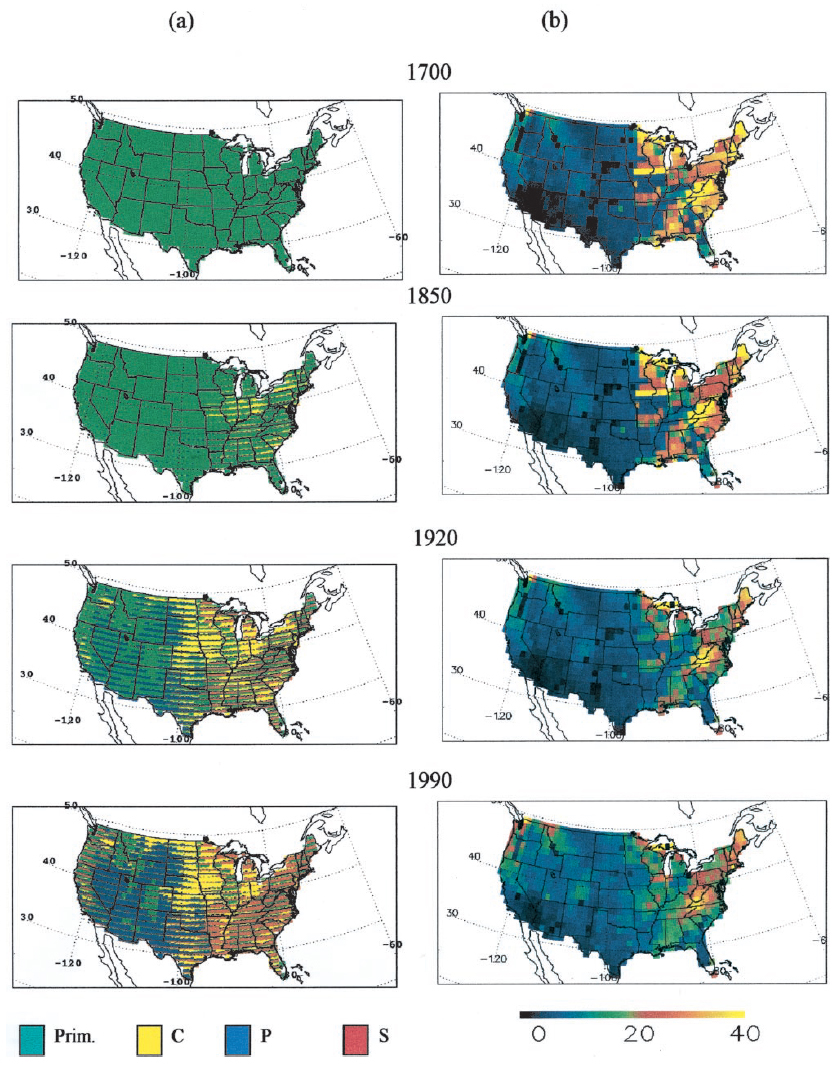
Federal
Ecosystem Demography Model: U.S. Ecosystem Carbon Stocks and Fluxes, 1700-1990
National Aeronautics and Space Administration —
This model product contains the source code for the Ecosystem Demography Model (ED version 1.0) as well as model input and output data files for the conterminous... -
Federal
GPM Ground Validation KRAX NEXRAD IPHEx V1
National Aeronautics and Space Administration —
The GPM Ground Validation KRAX NEXRAD IPHEx dataset contain data from the KRAX NEXt Generation Weather RADar system (NEXRAD) instruments in operation during the... -
Federal
LBA Regional Global Historical Climatology Network, V. 1, 1832-1990
National Aeronautics and Space Administration —
This data set consists of a subset of the Global Historical Climatology Network (GHCN) Version 1 database for the study area of the Large Scale Biosphere-Atmosphere... -
Federal
GPM GROUND VALIDATION NOAA CPC MORPHING TECHNIQUE (CMORPH) IPHEX V1
National Aeronautics and Space Administration —
The GPM Ground Validation NOAA CPC Morphing Technique (CMORPH) IPHEx dataset consists of global precipitation analyses data produced by the NOAA Climate Prediction... -
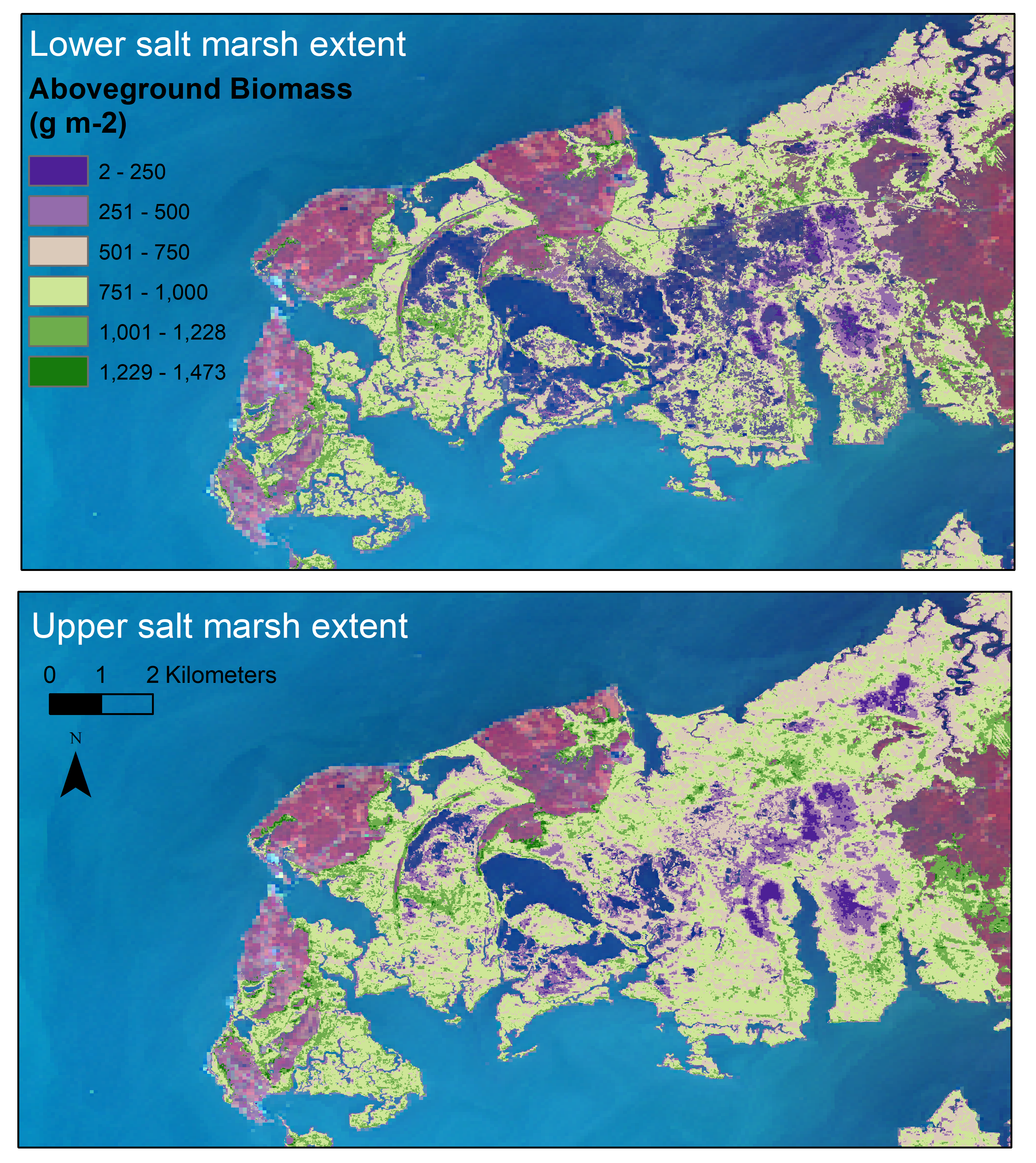
Federal
Aboveground Biomass Estimates for Salt Marsh for the Contiguous United States, 2020
National Aeronautics and Space Administration —
This dataset provides estimates of aboveground biomass (AGB) and salt marsh extent in the contiguous United States for 2020 and includes all coastal watersheds across... -
Federal
GPM Ground Validation KCAE NEXRAD IPHEx V1
National Aeronautics and Space Administration —
The GPM Ground Validation KCAE NEXRAD IPHEx datasets contain data from the KCAE NEXt Generation Weather RADar system (NEXRAD) instrument in operation during the...

Official websites use .gov
A
.gov website belongs to an official government
organization in the United States.
Secure .gov websites use HTTPS
A
lock (
) or https:// means you’ve safely connected to
the .gov website. Share sensitive information only on official,
secure websites.