

15 datasets found for "Hurricanes"
-
Federal
CYGNSS Level 1 Science Data Record Version 2.1
National Aeronautics and Space Administration —
This Level 1 (L1) dataset contains the Version 2.1 geo-located Delay Doppler Maps (DDMs) calibrated into Power Received (Watts) and Bistatic Radar Cross Section... -
Federal
CYGNSS Level 1 Science Data Record Version 3.2
National Aeronautics and Space Administration —
This CYGNSS Level 1 (L1) science data record dataset contains the version 3.2 geo-located Delay Doppler Maps (DDMs) calibrated into Power Received (Watts) and... -
Federal
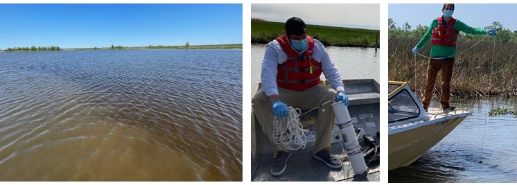
Delta-X: In Situ Water Surface Reflectance across MRD, LA, USA, 2021, V3
National Aeronautics and Space Administration —
This dataset includes above water measurements of remote-sensing reflectance measured in situ at field sampling stations during the Delta-X 2021 field efforts.... -
Federal
CYGNSS Level 3 MRG Science Data Record Version 3.2.2
National Aeronautics and Space Administration —
This dataset contains the version 3.2.2 CYGNSS level 3 science data record merged storm (MRG) wind speed which combines CYGNSS storm-centric gridded (SCG) wind... -
Federal
Delta-X: Total Suspended Solids Concentration across MRD, LA, USA, 2021, Version 2
National Aeronautics and Space Administration —
This dataset provides measurements of total suspended solids concentrations (TSS) of surface waters in the Atchafalaya River and Terrebonne Basins during the spring... -
Federal
Delta-X: Particulate Organic Carbon Concentration from Water Samples, MRD, LA, 2021
National Aeronautics and Space Administration —
This dataset provides measurements of particulate organic carbon (POC) concentrations made on water samples collected during 2021 in surface waters of the Atchafalaya... -
Federal
CYGNSS Level 3 Storm Centric Grid Science Data Record Version 1.0
National Aeronautics and Space Administration —
This dataset contains the Version 1.0 Cyclone Global Navigation Satellite System (CYGNSS) Level 3 Storm Centric Grid (SCG) Science Data Record (SDR) which provides... -
Federal
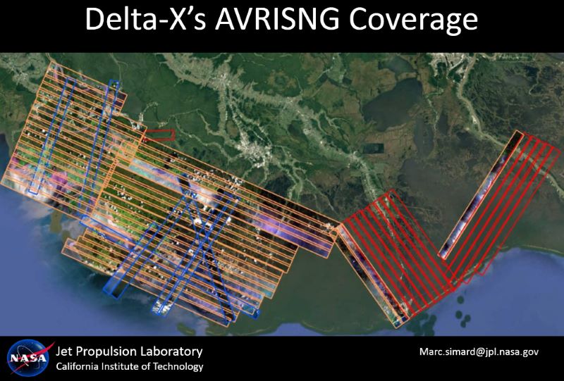
Delta-X: AVIRIS-NG L2 Surface Reflectance, MRD Louisiana, 2021
National Aeronautics and Space Administration —
This dataset provides Level 2 (L2) atmospherically corrected surface reflectance data acquired from NASA's Airborne Visible-Infrared Imaging Spectrometer-Next... -
Federal
CYGNSS Level 1 Climate Data Record Version 1.1
National Aeronautics and Space Administration —
This Level 1 (L1) dataset contains the Version 1.1 Climate Data Record (CDR) of the geo-located Delay Doppler Maps (DDMs) calibrated into Power Received (Watts) and... -
Federal
CYGNSS Level 1 Climate Data Record Version 1.2
National Aeronautics and Space Administration —
This Level 1 (L1) dataset contains the Version 1.2 Climate Data Record (CDR) of the geo-located Delay Doppler Maps (DDMs) calibrated into Power Received (Watts) and... -
Federal
TCSP ER-2 MICROWAVE TEMPERATURE PROFILER (MTP) V1
National Aeronautics and Space Administration —
The TCSP ER-2 Microwave Temperature Profiler (MTP) dataset was collected by the ER-2 Microwave Temperature Profiler (MTP), which is a passive microwave radiometer... -
Federal
CYGNSS Level 1 Climate Data Record Version 1.0
National Aeronautics and Space Administration —
This Level 1 (L1) dataset contains the Version 1.0 Climate Data Record (CDR) of the geo-located Delay Doppler Maps (DDMs) calibrated into Power Received (Watts) and... -
Federal
CYGNSS Level 2 Science Data Record Version 3.0
National Aeronautics and Space Administration —
This dataset contains the Version 3.0 CYGNSS Level 2 Science Data Record which provides the time-tagged and geolocated average wind speed (m/s) and mean square slope... -
Federal
CYGNSS Level 1 Science Data Record Version 3.0
National Aeronautics and Space Administration —
This Level 1 (L1) dataset contains the Version 3.0 geo-located Delay Doppler Maps (DDMs) calibrated into Power Received (Watts) and Bistatic Radar Cross Section... -
Federal
CYGNSS Level 1 Science Data Record Version 3.1
National Aeronautics and Space Administration —
This Level 1 (L1) dataset contains the Version 3.1 geo-located Delay Doppler Maps (DDMs) calibrated into Power Received (Watts) and Bistatic Radar Cross Section...
15 datasets found for "Hurricanes"