
-
Federal
Global Man-made Impervious Surface (GMIS) Dataset From Landsat
National Aeronautics and Space Administration —
The Global Man-made Impervious Surface (GMIS) Dataset From Landsat consists of global estimates of fractional impervious cover derived from the Global Land Survey... -
Federal
2010 Environmental Performance Index (EPI)
National Aeronautics and Space Administration —
The 2010 Environmental Performance Index (EPI) ranks 163 countries on environmental performance based on twenty-five indicators grouped within ten core policy... -
Federal
USGS Global Forest Observations Initiative (GFOI) Colombia
National Aeronautics and Space Administration —
The Global Forest Observations Initiative (GFOI) is an initiative of the inter-governmental Group on Earth Observations (GEO) that aims to: foster the sustained... -
Federal
LBA-ECO LC-09 Land Cover Transitions Maps for Study Sites in Para, Brazil: 1970-2001
National Aeronautics and Space Administration —
This data set includes classified land cover transition maps at 30-m resolution derived from Landsat TM, MSS, ETM+ imagery and aerial photos of Altamira, Santarem,... -
Federal
2008 Environmental Performance Index (EPI)
National Aeronautics and Space Administration —
The 2008 Environmental Performance Index (EPI) centers on two broad environmental protection objectives: (1) reducing environmental stresses on human health, and (2)... -
Federal
Global gene expression analysis highlights microgravity sensitive key genes in longissimus dorsi and tongue of 30 days space-flown mice
National Aeronautics and Space Administration —
Microgravity as well as chronic muscle disuse are two causes of low back pain originated at least in part from paraspinal muscle deconditioning. At present no study... -
Federal
Rodent Research-3-CASIS: Mouse liver transcriptomic proteomic and epigenomic data
National Aeronautics and Space Administration —
The Rodent Research-3 (RR-3) mission was sponsored by the pharmaceutical company Eli Lilly and Co. and the Center for the Advancement of Science in Space to study the... -
Federal
Global Human Built-up And Settlement Extent (HBASE) Dataset From Landsat
National Aeronautics and Space Administration —
The Global Human Built-up And Settlement Extent (HBASE) Dataset from Landsat is a global map of HBASE derived from the Global Land Survey (GLS) Landsat dataset for... -
Federal
Rodent Research-3-CASIS: Mouse adrenal gland transcriptomic proteomic and epigenomic data
National Aeronautics and Space Administration —
The Rodent Research-3 (RR-3) mission was sponsored by the pharmaceutical company Eli Lilly and Co. and the Center for the Advancement of Science in Space to study the... -
Federal
2012 Environmental Performance Index and Pilot Trend Environmental Performance Index
National Aeronautics and Space Administration —
The 2012 Environmental Performance Index (EPI) ranks 132 countries on 22 performance indicators in the following 10 policy categories: environmental burden of... -
Federal
LBA-ECO LC-14 Modeled Deforestation Scenarios, Amazon Basin: 2002-2050
National Aeronautics and Space Administration —
This data set provides the results of the two modeled scenarios for future patterns of deforestation across the Amazon Basin from 2002 to 2050. This larger defined... -
Federal
Gridded GEDI Vegetation Structure Metrics and Biomass Density at Multiple Resolutions
National Aeronautics and Space Administration —
This dataset consists of near-global, analysis-ready, multi-resolution gridded vegetation structure metrics derived from NASA Global Ecosystem Dynamics Investigation... -
Federal
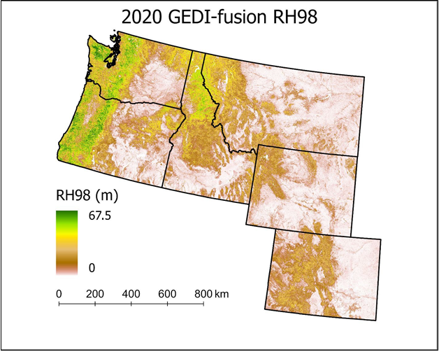
Gridded GEDI-Fusion Forest Structure Metrics across Six Western US States, 2016-2020
National Aeronautics and Space Administration —
This dataset provides eight GEDI forest structure metrics relevant to wildlife habitat modeling and biodiversity assessments at 30-m resolutions across Washington,... -
Federal
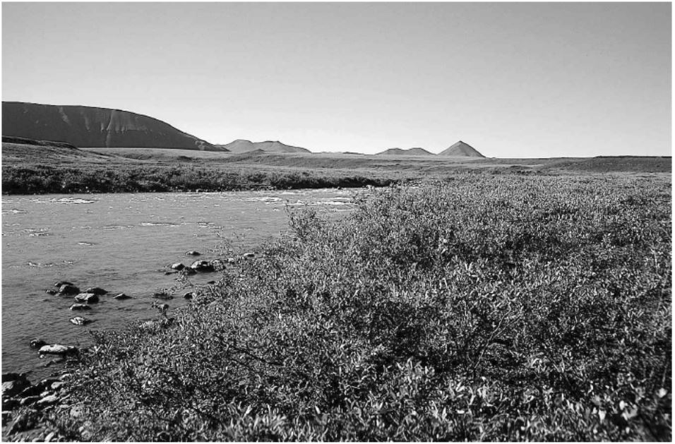
Arctic Vegetation Plots in Willow Communities, North Slope, Alaska, 1997
National Aeronautics and Space Administration —
This data set provides environmental, soil, and vegetation data collected in July and August 1997 from 85 study plots in willow shrub communities located along a... -
Federal
West Africa Coastal Vulnerability Mapping: Deforestation, 2000-2012
National Aeronautics and Space Administration —
The West Africa Coastal Vulnerability Mapping: Deforestation, 2000-2012, layer was created from the Global Forest Change data set which represents global tree cover... -
Federal
Aerial Photographs (from AMES Pilot Land Data System); USGS EDC, Sioux Falls
National Aeronautics and Space Administration —
The aerial photography inventoried by the Pilot Land Data System (PLDS) at NASA AMES Research Center has been transferred to the USGS EROS Data Center. The photos... -
Federal
Spatially resolved transcriptional analysis of brains from mice flown on the RR-3 mission
National Aeronautics and Space Administration —
The Rodent Research-3 (RR-3) mission was sponsored by the pharmaceutical company Eli Lilly and Co. and the Center for the Advancement of Science in Space to study the...

Official websites use .gov
A
.gov website belongs to an official government
organization in the United States.
Secure .gov websites use HTTPS
A
lock (
) or https:// means you’ve safely connected to
the .gov website. Share sensitive information only on official,
secure websites.