
-
Federal
ABoVE: Thaw Depth at Selected Unburned and Burned Sites Across Alaska
National Aeronautics and Space Administration —
This dataset provides thaw depth measurements made at seven locations across Alaska, during August 2016, June and September 2017, and July-August 2018. Three of the... -
Federal
Land Use and Cover Maps from Landsat, Mawas, Central Kalimantan, Indonesia, 1994-2019
National Aeronautics and Space Administration —
This dataset contains annual land use/cover (LUC) maps at 30 m resolution across Mawas, Central Kalimantan, Indonesia. There are six files, each representing a five-... -
Federal
LBA-ECO LC-09 Land Cover Transitions Maps for Study Sites in Para, Brazil: 1970-2001
National Aeronautics and Space Administration —
This data set includes classified land cover transition maps at 30-m resolution derived from Landsat TM, MSS, ETM+ imagery and aerial photos of Altamira, Santarem,... -
Federal
RADARSAT-1 Level 0 Product
National Aeronautics and Space Administration —
RADARSAT-1 Level 0 -
Federal
BOREAS RSS-20 POLDER C-130 Measurements of Surface BRDF
National Aeronautics and Space Administration —
This data set contains measurements of surface BRDF made by the POLDER instrument over several surface types (pine, spruce, fen) of the BOREAS SSA during the 1994... -
Federal
ABoVE: Active Layer Soil Characteristics at Selected Sites Across Alaska
National Aeronautics and Space Administration —
This dataset provides soil active layer characteristics from nine locations across Alaska. Soil samples were collected in 2016 except for one site which was sampled... -
Federal
ALOS PALSAR Level 1.0 Product
National Aeronautics and Space Administration —
ALOS PALSAR Level 1.0 -
Federal
In-situ Air Temperature and Relative Humidity in Greenbelt, MD, 2013-2015
National Aeronautics and Space Administration —
This data set describes the temperature and relative humidity at 12 locations around Goddard Space Flight Center in Greenbelt MD at 15 minute intervals between... -
Federal
NPP Tropical Forest: Gunung Mulu, Malaysia, 1977-1978, R1
National Aeronautics and Space Administration —
This data set contains seven ASCII data files (.txt format). Four files provide NPP data for contrasting lowland rainforests within Gunung Mulu National Park on the... -
Federal
NACP Site: Terrestrial Biosphere Model and Aggregated Flux Data in Standard Format
National Aeronautics and Space Administration —
This data set provides standardized output variables for gross primary productivity (GPP), net ecosystem exchange (NEE), leaf area index (LAI), ecosystem respiration... -
Federal
ALOS PALSAR Level 1.1 Product
National Aeronautics and Space Administration —
ALOS PALSAR Level 1.1 -
Federal
NPP Multi-Biome: Gridded Estimates for Selected Regions Worldwide, 1954-1998, R3
National Aeronautics and Space Administration —
This data set provides two data files (.csv format) containing gridded (0.5-degree) estimates of net primary productivity (NPP), elevation, temperature,... -
Federal
NPP Multi-Biome: Summary Data from Intensive Studies at 125 Sites, 1936-2006
National Aeronautics and Space Administration —
This data set, NPP Multi-Biome: Summary Data from Intensive Studies at 125 Sites, 1936-2006, contains a single shapefile that provides site-level summary statistics... -
Federal
ABoVE: Wetland Type, Slave River and Peace-Athabasca Deltas, Canada, 2007 and 2017
National Aeronautics and Space Administration —
This dataset provides ecosystem-types for the Slave River Delta (SRD) and Peace-Athabasca Delta (PAD), Canada, for the time periods circa 2007 and circa 2017. The... -
Federal
SAFARI 2000 Vegetation Cover Characteristics, Kalahari Transect, Wet Season 2000
National Aeronautics and Space Administration —
Vegetation cover and composition, including species types and richness assessments, were measured at four locations along the Kalahari Transect in Botswana... -
Federal
BioSCape: BioSoundSCape Acoustic Recordings, South Africa, 2023
National Aeronautics and Space Administration —
This dataset holds in situ sound recordings from sites in Greater Cape Floristic Region (GCFR), South Africa from June to December 2023. The recordings were collected... -
Federal
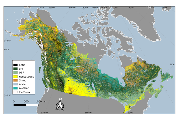
ABoVE: Landsat-derived Annual Dominant Land Cover in Boreal North America, 1986-2020
National Aeronautics and Space Administration —
This dataset contains a 30-m resolution time series of annual land cover classifications as the dominant plant functional type class for all of boreal Alaska and... -
Federal
ACEPOL Research Scanning Polarimeter (RSP) Remotely Sensed Data Version 1
National Aeronautics and Space Administration —
ACEPOL Research Scanning Polarimeter (RSP) Remotely Sensed Data (ACEPOL_AircraftRemoteSensing_RSP_Data) are remotely sensed measurements collected by the Research... -
Federal
ABoVE: Wetland Vegetation Classification for Peace-Athabasca Delta, Canada, 2019
National Aeronautics and Space Administration —
This dataset contains land cover classification focused on water and wetland vegetation communities over the Peace-Athabasca Delta, Canada. Four classification maps...

Official websites use .gov
A
.gov website belongs to an official government
organization in the United States.
Secure .gov websites use HTTPS
A
lock (
) or https:// means you’ve safely connected to
the .gov website. Share sensitive information only on official,
secure websites.