
-
Federal
ACES Aircraft and Mechanical Data V1
National Aeronautics and Space Administration —
The ACES Aircraft and Mechanical Data consist of aircraft (e.g. pitch, roll, yaw) and mechanical (e.g. aircraft engine speed, tail commands, fuel levels) data... -
Federal
TRMM Ground Validation Calibrated QC Radar Reflectivity Full Volume Scan L1C 1 hour V7 (TRMM_1C51UW) at GES DISC
National Aeronautics and Space Administration —
This dataset is part of the University of Washington TRMM Ground Validation products. Files are in "Universal Format", described in BAMS, Vol 61, No 11, November... -
Federal
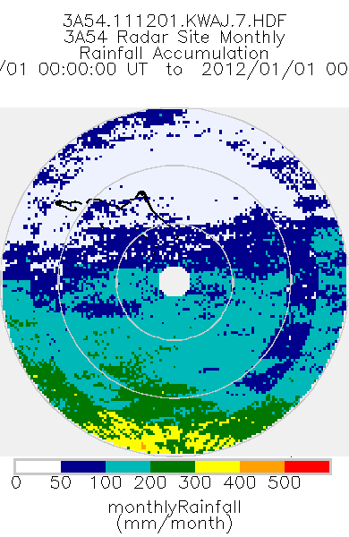
TRMM Ground Validation Radar Site Rain Type Totals Map L3 1 month 2 km V7 (TRMM_3A54) at GES DISC
National Aeronautics and Space Administration —
The 3A54 product, 'Site Rainfall Map', is a map of monthly surface rain totals derived from the instantaneous rain rate maps (2A53). The map is in Cartesian... -
Federal
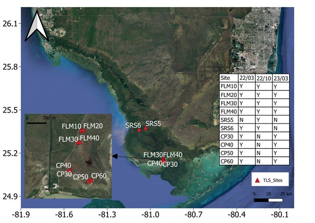
Blueflux: Terrestrial Lidar Scans of Mangrove Forests, Everglades, FL, USA, 2022-2023
National Aeronautics and Space Administration —
This dataset contains point clouds of three-dimensional (3D) mangrove forest structure and volume collected from 10 sites in Everglades National Park, Florida. Data... -
Federal
CAMEX-4 NOAA LYMAN-ALPHA HYGROMETER V1
National Aeronautics and Space Administration —
The CAMEX-4 NOAA Lyman-Alpha Hygrometer dataset was collected by the NOAA Lyman-alpha Total Water Hygrometer, which was flown during the fourth field campaign in the... -
Federal
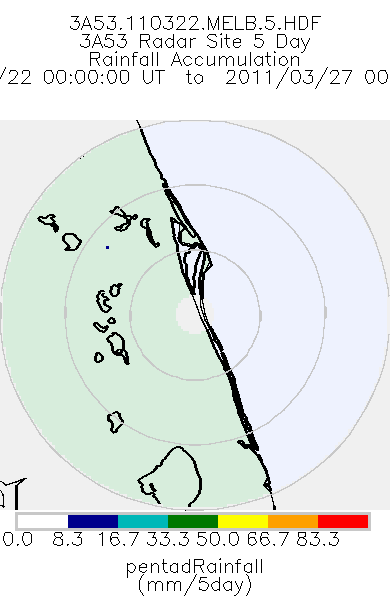
TRMM Ground Validation Radar Site Rain Totals Map L3 5 days 2 km V7 (TRMM_3A53) at GES DISC
National Aeronautics and Space Administration —
This is the 5-day accumulation of the 2A53 product, 'Radar Site Rain Map', which originally is an instantaneous surface rain rate map in Cartesian coordinates with a... -
Federal
MASTER: FireSense, California and Southern US, Spring 2025
National Aeronautics and Space Administration —
This dataset includes Level 1B (L1B) and Level 2 (L2) data products from the MODIS/ASTER Airborne Simulator (MASTER) instrument. The spectral data were collected as... -
Federal
CAMEX-3 DC-8 NAVIGATION (DADS) DATA V1
National Aeronautics and Space Administration —
The CAMEX-3 DC-8 Navigation Data Acquisition and Distribution System (DADS) data files contain information recorded by navigation and data collection systems onboard... -
Federal
MASTER: BP Oil Spill Mapping, Louisiana-Gulf of Mexico-Wisconsin, Fall, 2010
National Aeronautics and Space Administration —
This dataset includes Level 1B (L1B) and Level 2 (L2) data products from the MODIS/ASTER Airborne Simulator (MASTER) instrument. The raw data were collected during 9... -
Federal
AMPR TEFLUN-A BRIGHTNESS TEMPERATURE (TB)
National Aeronautics and Space Administration —
The Advanced Microwave Precipitation Radiometer (AMPR) was deployed during the Texas-Florida Underflights (TEFLUN-A); the first of three TRMM ground validation... -
Federal
TRMM Ground Validation Calibrated QC Radar Reflectivity Full Volume Scan L1C 1 hour V7 (TRMM_1C51) at GES DISC
National Aeronautics and Space Administration —
The purpose of the 1C51 algorithm is to remove non-meteorological radar echoes that adversely affect the quality of higher level products, such as clutter associated... -
Federal
CAMEX-4 ER-2 DOPpler radar (EDOP)
National Aeronautics and Space Administration —
The reprocessed ER-2 Doppler Radar (EDOP) data were collected during the fourth field campaign in the Convection And Moisture EXperiment (CAMEX) series, CAMEX-4. This... -
Federal
CAMEX-3 LiDAR Atmospheric Sensing Experiment (LASE) Imagery
National Aeronautics and Space Administration —
The CAMEX-3 LiDAR Atmospheric Sensing Experiment (LASE) Imagery dataset is a browse-only dataset that consists of plotted reflectivity data collected by the LiDAR... -
Federal
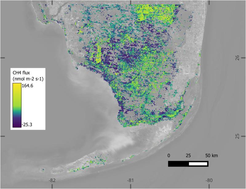
BlueFlux: Modeled Daily CO2 and CH4 Wetland Fluxes, Southern Florida, 2000-2024
National Aeronautics and Space Administration —
This dataset contains gridded estimates of carbon dioxide (CO2) and methane (CH4) fluxes at daily resolution covering the Southern Florida region from 2000 to 2024.... -
Federal
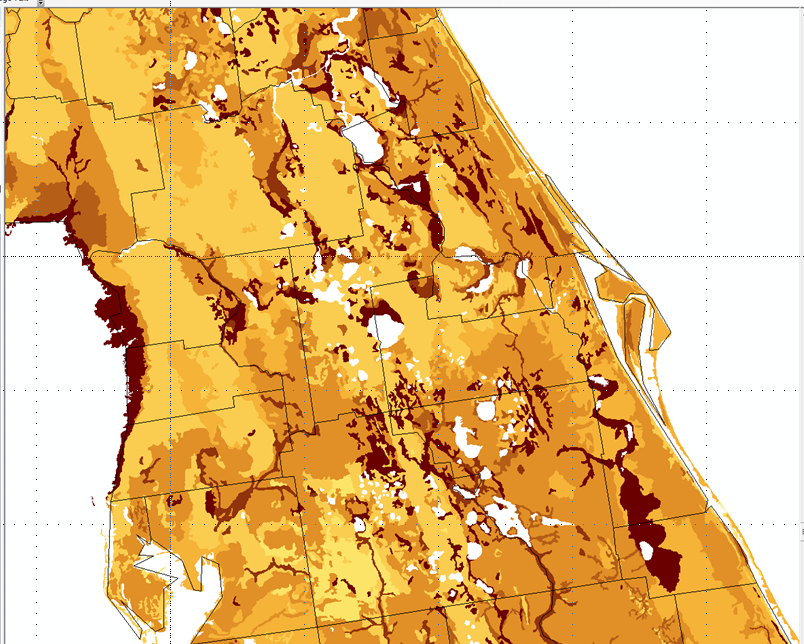
Soil Carbon Estimates in 20-cm Layers to 1-meter Depth, Conterminous US, 1970-1993
National Aeronautics and Space Administration —
This data set provides a soil map with estimates of soil carbon (C) in g C/m2 for 20-cm layers from the surface to one meter depth for the conterminous United... -
Federal
TRMM Ground Validation Radar Site Rain Totals Map L3 5 days 2 km V7 (TRMM_3A53) at GES DISC
National Aeronautics and Space Administration —
This is the 5-day accumulation of the 2A53 product, 'Radar Site Rain Map', which originally is an instantaneous surface rain rate map in Cartesian coordinates with a... -
Federal
TRMM TROPICAL CYCLONE PRECIPITATION FEATURE (TCPF) DATABASE - LEVEL 1 V1
National Aeronautics and Space Administration —
The TRMM Cyclone Precipitation Feature (TCPF) Database - Level 1 provides Tropical Rainfall Measuring Mission (TRMM)-based tropical cyclone data in a common framework... -
Federal
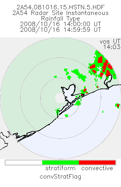
TRMM Ground Validation Radar Site Rain Type Map L2 1 hour 2 km V7 (TRMM_2A54) at GES DISC
National Aeronautics and Space Administration —
'Radar Site Convective/Stratiform Map', is an instantaneous map in Cartesian coordinates with a 2 km resolution. At single radar sites, the map covers an area of 300... -
Federal
TRMM Ground Validation Radar Reflectivity Single Level Cartesian Grid 1 hour V7 (TRMM_baseUW) at GES DISC
National Aeronautics and Space Administration —
This dataset is part of the University of Washington TRMM Ground Validation products. Data contains single level, cartesian grids containing output of NCAR SPRINT...

Official websites use .gov
A
.gov website belongs to an official government
organization in the United States.
Secure .gov websites use HTTPS
A
lock (
) or https:// means you’ve safely connected to
the .gov website. Share sensitive information only on official,
secure websites.