
-
Federal
CYGNSS Level 1 Science Data Record Version 3.2
National Aeronautics and Space Administration —
This CYGNSS Level 1 (L1) science data record dataset contains the version 3.2 geo-located Delay Doppler Maps (DDMs) calibrated into Power Received (Watts) and... -
Federal
CYGNSS Level 3 Science Data Record Version 3.2
National Aeronautics and Space Administration —
This dataset contains the version 3.2 CYGNSS level 3 science data record which provides the average wind speed and mean square slope (MSS) on a 0.2x0.2 degree... -
Federal
CYGNSS Level 3 MRG Science Data Record Near Real Time Version 3.2.1
National Aeronautics and Space Administration —
This dataset contains the version 3.2.1 CYGNSS Level 3 Merged (MRG) Science Data Record Near Real Time (NRT) Storm Wind Speed derived from the Delay Doppler Mapping... -
Federal
CYGNSS Level 3 MRG Science Data Record Near Real Time Version 3.2
National Aeronautics and Space Administration —
This dataset contains the version 3.2 CYGNSS Level 3 Merged (MRG) Science Data Record Near Real Time (NRT) Storm Wind Speed derived from the Delay Doppler Mapping... -
Federal
HIRENASD Beam FEM
National Aeronautics and Space Administration —
This contains attempts to create BEAM FEM model. I have started a Blog to discuss this... please put your comments there and I will attempt to keep everything... -
Federal
CYGNSS Level 3 MRG Science Data Record Near Real Time Version 3.2.2
National Aeronautics and Space Administration —
CYGNSS_L3_MRG_NRT_V3.2.2This dataset contains the Near Real Time (NRT) version of the 3.2.2 CYGNSS Level 3 Merged (MRG) Science Data Record Wind Speed which combines... -
Federal
CYGNSS Level 3 MRG Science Data Record Version 3.2.2
National Aeronautics and Space Administration —
This dataset contains the version 3.2.2 CYGNSS level 3 science data record merged storm (MRG) wind speed which combines CYGNSS storm-centric gridded (SCG) wind... -
Federal
CYGNSS Level 3 Ocean Microplastic Concentration Version 3.2
National Aeronautics and Space Administration —
The CYGNSS L3 Ocean Microplastic Concentration V3.2 dataset is provided by the CYGNSS Science Team of the University of Michigan.CYGNSS was launched on 15 December... -
Federal
CYGNSS Level 3 MRG Science Data Record Version 3.2.1
National Aeronautics and Space Administration —
This dataset contains the version 3.2.1 CYGNSS level 3 science data record merged storm (MRG) wind speed which combines CYGNSS storm-centric gridded (SCG) wind... -
Federal
CYGNSS Level 3 Soil Moisture Version 3.2
National Aeronautics and Space Administration —
The CYGNSS Level 3 Soil Moisture V3.2 dataset is provided by the CYGNSS Science Team of the University of Michigan. It estimates volumetric water content for soils... -
Federal
UC Berkeley CYGNSS Level 3 Daily RWAWC Watermask Version 3.2
National Aeronautics and Space Administration —
The CYGNSS Level 3 UC Berkeley Watermask Record Version 3.2 was developed by CYGNSS investigators in the Department of Civil and Environmental Engineering at the... -
Federal
VISSR/SMS-1 Level 1 Experimenter History Data V001 (VISSRSMS1L1EHT) at GES DISC
National Aeronautics and Space Administration —
VISSRSMS1L1EHT is the Visible Infrared Spin-Scan Radiometer (VISSR) Level 1 Experimenter History Tape (EHT) data product from the first Synchronous Meteorological... -
Federal
VISSR/SMS-2 Level 1 Experimenter History Data V001 (VISSRSMS2L1EHT) at GES DISC
National Aeronautics and Space Administration —
VISSRSMS2L1EHT is the Visible Infrared Spin-Scan Radiometer (VISSR) Level 1 Experimenter History Tape (EHT) data product from the second Synchronous Meteorological... -
Federal
VISSR/SMS-1 Level 1 Atmospheric and Oceanographic Image Processing System (AOIPS) Data V001 (VISSRSMS1L1AOIPS) at GES DISC
National Aeronautics and Space Administration —
VISSRSMS1L1AOIPS is the Visible Infrared Spin-Scan Radiometer (VISSR) Level 1 Atmospheric and Oceanographic Image Processing System (AOIPS) data product from the... -
Federal
VISSR/SMS-2 Level 1 Atmospheric and Oceanographic Image Processing System (AOIPS) Data V001 (VISSRSMS2L1AOIPS) at GES DISC
National Aeronautics and Space Administration —
VISSRSMS2L1AOIPS is the Visible Infrared Spin-Scan Radiometer (VISSR) Level 1 Atmospheric and Oceanographic Image Processing System (AOIPS) data product from the... -
Federal
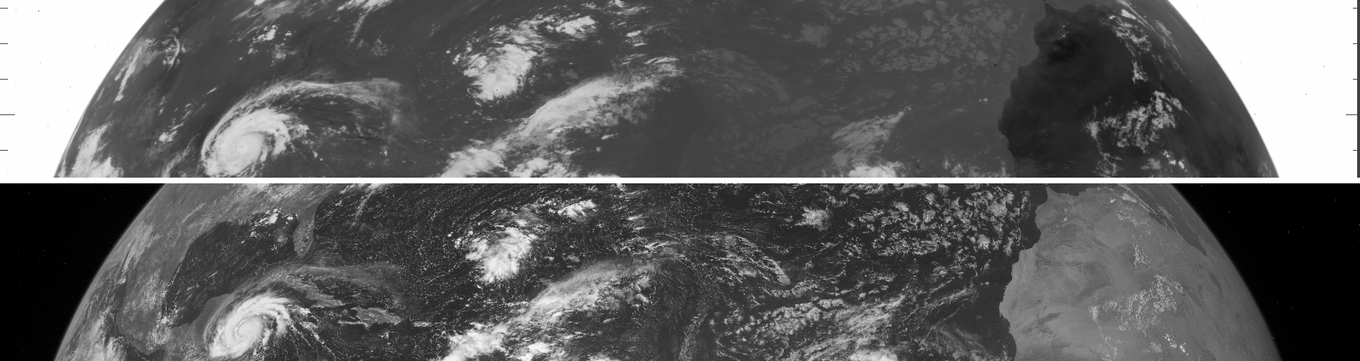
VISSR/GOES-1 Infrared Imagery on 70mm Film V001 (VISSRGOES1IMIR) at GES DISC
National Aeronautics and Space Administration —
VISSRGOES1IMIR is the Visible Infrared Spin-Scan Radiometer (VISSR) Infrared Imagery on 70mm Film data product from the first Geostationary Operational Environmental... -
Federal
CYGNSS Level 3 MRG Science Data Record Version 3.2
National Aeronautics and Space Administration —
This dataset contains the version 3.2 CYGNSS level 3 science data record merged storm (MRG) wind speed which combines CYGNSS storm-centric gridded (SCG) wind speeds,... -
Federal
CYGNSS Level 1 Calibrated Raw IF Version 1.0
National Aeronautics and Space Administration —
The CYGNSS Level 1 Calibrated Raw IF Version 1.0 dataset is produced by the CYGNSS Science Team of the University of Michigan, and it contains the first release,... -
Federal
CYGNSS Level 2 Ocean Surface Heat Flux Science Data Record Version 3.2
National Aeronautics and Space Administration —
The CYGNSS level 2 ocean surface heat flux science data record version 3.2 dataset is provided as a service to the oceanographic and meteorological research...

Official websites use .gov
A
.gov website belongs to an official government
organization in the United States.
Secure .gov websites use HTTPS
A
lock (
) or https:// means you’ve safely connected to
the .gov website. Share sensitive information only on official,
secure websites.