
-
Federal
ABoVE: Ignitions, Burned Area, and Emissions of Fires in AK, YT, and NWT, 2001-2018
National Aeronautics and Space Administration —
This dataset provides estimates of daily burned area, carbon emissions, and uncertainty, and daily fire ignition locations for boreal fires in Alaska, U.S., and in... -
Federal
CMS: Forest Carbon Stocks, Emissions, and Net Flux for the Conterminous US: 2005-2010
National Aeronautics and Space Administration —
This data set provides maps of estimated carbon in forests of the 48 continental states of the US for the years 2005-2010. Carbon (termed committed carbon) stocks... -
Federal
LBA-ECO ND-02 Soil Gas Flux, Rainfall Exclusion, km 67, Tapajos National Forest
National Aeronautics and Space Administration —
Moist tropical forests in Amazonia and elsewhere are subjected to increasingly severe drought episodes through the El Nino-Southern Oscillation (ENSO) and possibly... -
Federal
NPP Tropical Forest: Cinnamon Bay, U.S. Virgin Islands, 1982-1993, R1
National Aeronautics and Space Administration —
This data set contains three ASCII files (.txt format). One data file contains above-ground biomass, litter, litterfall, herbivory, biomass change, and above-ground... -
Federal
LBA-ECO CD-05 Understory Fuel Stick Moisture, km 67 Site, Para, Brazil: 1998-2000
National Aeronautics and Space Administration —
This data set contains moisture content measurements for fuel sticks located in the forest understory of the rainfall exclusion experimental site, Tapajos National... -
Federal
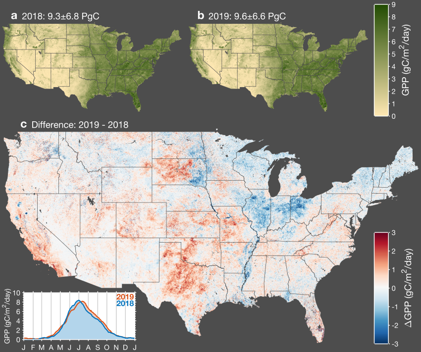
CMS: Daily Gross Primary Productivity over CONUS from TROPOMI SIF, 2018-2021
National Aeronautics and Space Administration —
This dataset includes estimates of gross primary production (GPP) for the conterminous U.S., for 2018-02-15 to 2021-10-15, based on measurements of solar-induced... -
Federal
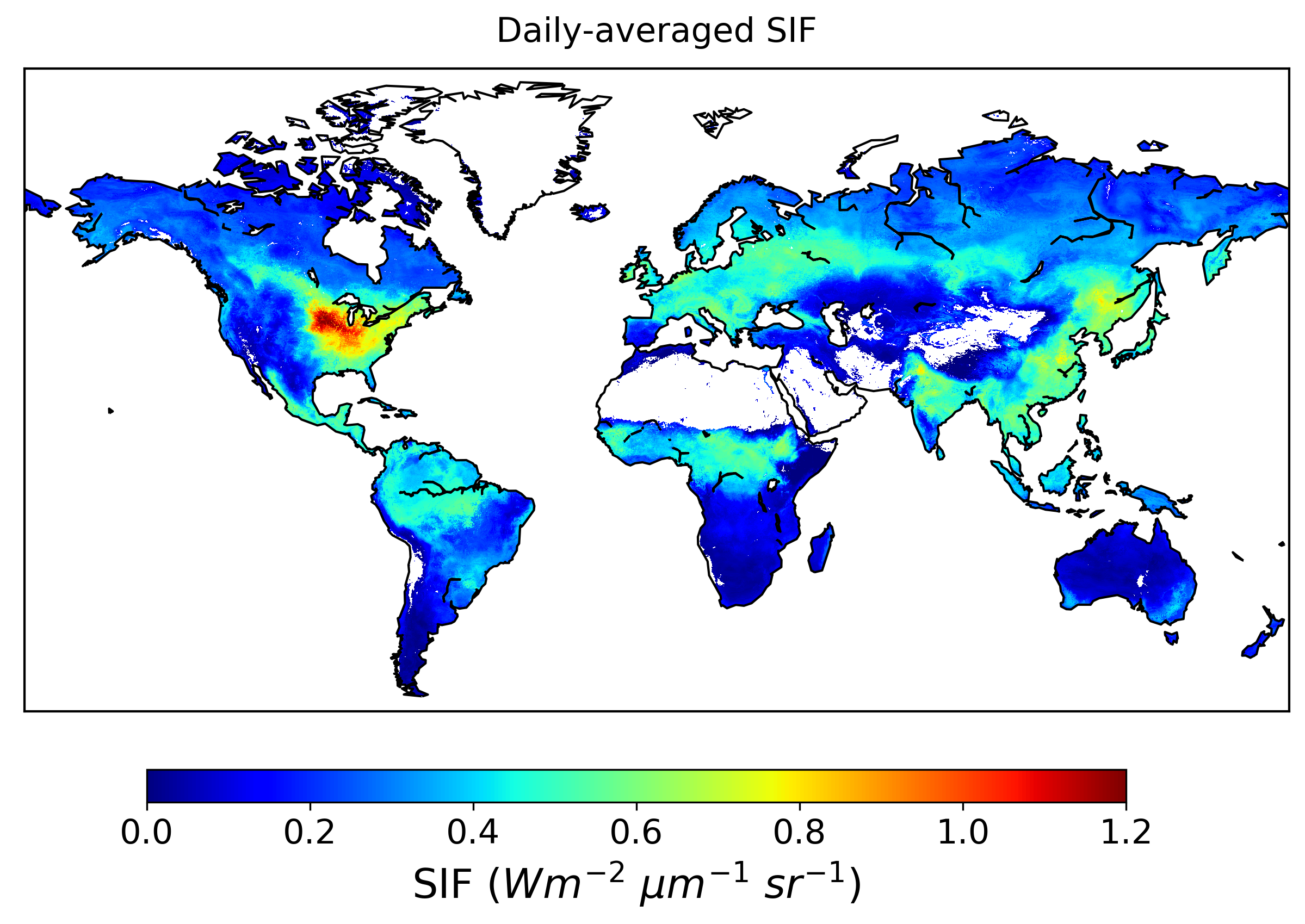
High Resolution Global Contiguous SIF Estimates from OCO-2 SIF and MODIS, Version 2
National Aeronautics and Space Administration —
This dataset provides spatially-contiguous global mean daily solar-induced chlorophyll fluorescence (SIF) estimates at 0.05 degree (approximately 5 km at the equator)... -
Federal
NACP: Forest Carbon Stocks, Fluxes and Productivity Estimates, Western USA, 1979-2099
National Aeronautics and Space Administration —
This dataset contains annual estimates of carbon stocks, fluxes, and productivity over forested land in 11 states of the western USA (Arizona, California, Colorado,... -
Federal
NPP Cropland: Gridded Estimates For the Central USA, 1982-1996, R1
National Aeronautics and Space Administration —
This data set contains a single data file (.csv format) that provides gridded values of net primary productivity (NPP) for cropland in eight counties in the central... -
Federal
LBA-ECO LC-14 Modeled Soil and Plant Water Balance, Amazon Basin, 1995-2001
National Aeronautics and Space Administration —
A simple GIS soil-water balance model for the Amazon Basin, called RisQue (Risco de Queimadasa -- Fire Risk), was used to conduct an analysis of spatial and temporal... -
Federal
SAFARI 2000 FEWS 10-day Rainfall Estimate, 8-Km, 1999-2001
National Aeronautics and Space Administration —
The U.S. Agency for International Development (USAID) Famine Early Warning System (FEWS) has been supporting the production of 10-day Rainfall Estimate (RFE) data for... -
Federal
CMS: Fire Weather Indices for Interior Alaska, 2001-2010
National Aeronautics and Space Administration —
This dataset provides daily fire weather indices for interior Alaska during the active fire seasons from 2001 to 2010. Data are gridded at 60-m resolution. The active... -
Federal
Global High-Resolution Estimates of SIF from Fused SCIAMACHY and GOME-2, V2
National Aeronautics and Space Administration —
This dataset provides global solar-induced chlorophyll fluorescence (SIF) estimates at a 0.05-degree resolution (approximately 5 km at the equator) for each month... -
Federal
LBA-ECO CD-05 Forest Understory Fuel Loads, Paragominas, Para, Brazil: 2001
National Aeronautics and Space Administration —
This data set contains estimates of understory fuel loads (forest litter) at six locations near Paragominas in Northeastern Amazonia. Samples were collected from... -
Federal
LBA-ECO CD-05 Soil VWC and Meteorology, Rainfall Exclusion, Tapajos National Forest
National Aeronautics and Space Administration —
This data set reports soil moisture expressed as volumetric water content (VWC), daily precipitation, air temperature, relative humidity, and dew point measurements... -
Federal
LBA-ECO CD-06 Carbon Cycling in Rivers in Amazonas and Acre, Brazil: 2005-2006
National Aeronautics and Space Administration —
This data set provides measured and calculated variables describing the carbon pools in river waters, CO2 respired from the water and total amount of CO2 evaded,... -
Federal
A Global Database of Field-observed Leaf Area Index in Woody Plant Species, 1932-2011
National Aeronautics and Space Administration —
This data set provides global leaf area index (LAI) values for woody species. The data are a compilation of field-observed data from 1,216 locations obtained from 554... -
Federal
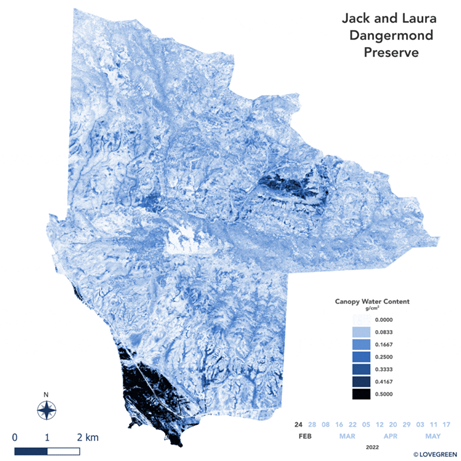
SHIFT: AVIRIS-NG Derived Gridded Mosaicked Canopy Water Content, California, 2022
National Aeronautics and Space Administration —
This dataset provides per-pixel vegetation canopy water content (CWC) derived from surface reflectance measured by the Airborne Visible/Infrared Imaging Spectrometer-...

Official websites use .gov
A
.gov website belongs to an official government
organization in the United States.
Secure .gov websites use HTTPS
A
lock (
) or https:// means you’ve safely connected to
the .gov website. Share sensitive information only on official,
secure websites.