
-
Federal
LBA-ECO LC-04 Satellite/Census-Based 5-Minute Land Use Data, Amazonia: 1980 and 1995
National Aeronautics and Space Administration —
Amazonia has been under considerable development pressure as croplands and pasture are established in areas formerly occupied by tropical forest and cerrado. Although... -
Federal
LBA-ECO LC-04 IBIS Model Simulations for the Amazon and Tocantins Basins: 1921-1998
National Aeronautics and Space Administration —
The provided data were generated by the Integrated BIosphere Simulator (IBIS) terrestrial ecosystem model (Foley et al. 1996, Kucharik et al. 2000) using data from... -
Federal
BOREAS HYD-08 Throughfall Data
National Aeronautics and Space Administration —
The BOREAS HYD-08 team made measurements of surface hydrological processes at the SSA (1996) and NSA OBS (1994) Tower Flux sites, supporting its research into point... -
Federal
LBA Regional Hydrographic Data, 1-Degree, Release 2.2 (Cogley)
National Aeronautics and Space Administration —
This subset of the Global Hydrographic data set (GGHYDRO) Release 2.2 for the study area of the Large Scale Biosphere-Atmosphere Experiment in Amazonia (LBA) in South... -
Federal
ABoVE: Wetland Type, Slave River and Peace-Athabasca Deltas, Canada, 2007 and 2017
National Aeronautics and Space Administration —
This dataset provides ecosystem-types for the Slave River Delta (SRD) and Peace-Athabasca Delta (PAD), Canada, for the time periods circa 2007 and circa 2017. The... -
Federal
LBA-ECO LC-04 Macrohydrological Routing Data for the Amazon and Tocantins River Basin
National Aeronautics and Space Administration —
This data set provides continental-scale hydrological river flow routing parameter data for the Amazon and Tocantins River basins at 5 minute (~9 km) resolution... -
Federal
LBA-ECO CD-06 Amazon River Basin Land and Stream Drainage Direction Maps
National Aeronautics and Space Administration —
This data set provides high-resolution (~500 m) gridded land and stream drainage direction maps for the Amazon River basin, excluding the Rio Tocantins basin. These... -
Federal
LBA Regional Vegetation and Soils, 1-Degree (Wilson and Henderson-Sellers)
National Aeronautics and Space Administration —
This data set is a subset of a global vegetation and soils data set by Wilson and Henderson-Sellers (1985a). The subset was created for the study area of the Large... -
Federal
SAFARI 2000 Vegetation and Soils, 1-Deg (Wilson and Henderson-Sellers)
National Aeronautics and Space Administration —
This data set contains a subset for southern Africa of Wilson and Henderson-Sellers' Global Vegetation & Soils 1-degree data. The data are available in both ASCII... -
Federal
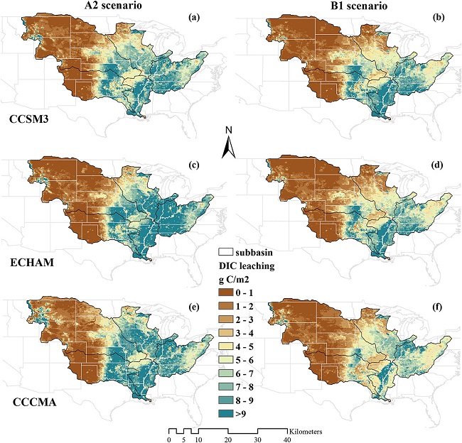
Export and Leaching of Carbon and Nitrogen from Mississippi River Basin, 1901-2099
National Aeronautics and Space Administration —
This dataset provides estimates for export and leaching of dissolved inorganic carbon (DIC), dissolved organic carbon (DIC), total organic carbon (TOC), particulate... -
Federal
BOREAS TGB-12 Soil Carbon and Flux Data of NSA-MSA in Raster Format
National Aeronautics and Space Administration —
The BOREAS TGB-12 team made measurements of soil carbon inventories, carbon concentration in soil gases, and rates of soil respiration at several sites. This data set... -
Federal
PnET-BGC: Modeling Biogeochemical Processes in a Northern Hardwood Forest Ecosystem
National Aeronautics and Space Administration —
This archived model product contains the directions, executables, and procedures for running PnET-BGC to recreate the results of Gbondo-Tugbawa, S.S., C.T. Driscoll ,... -
Federal
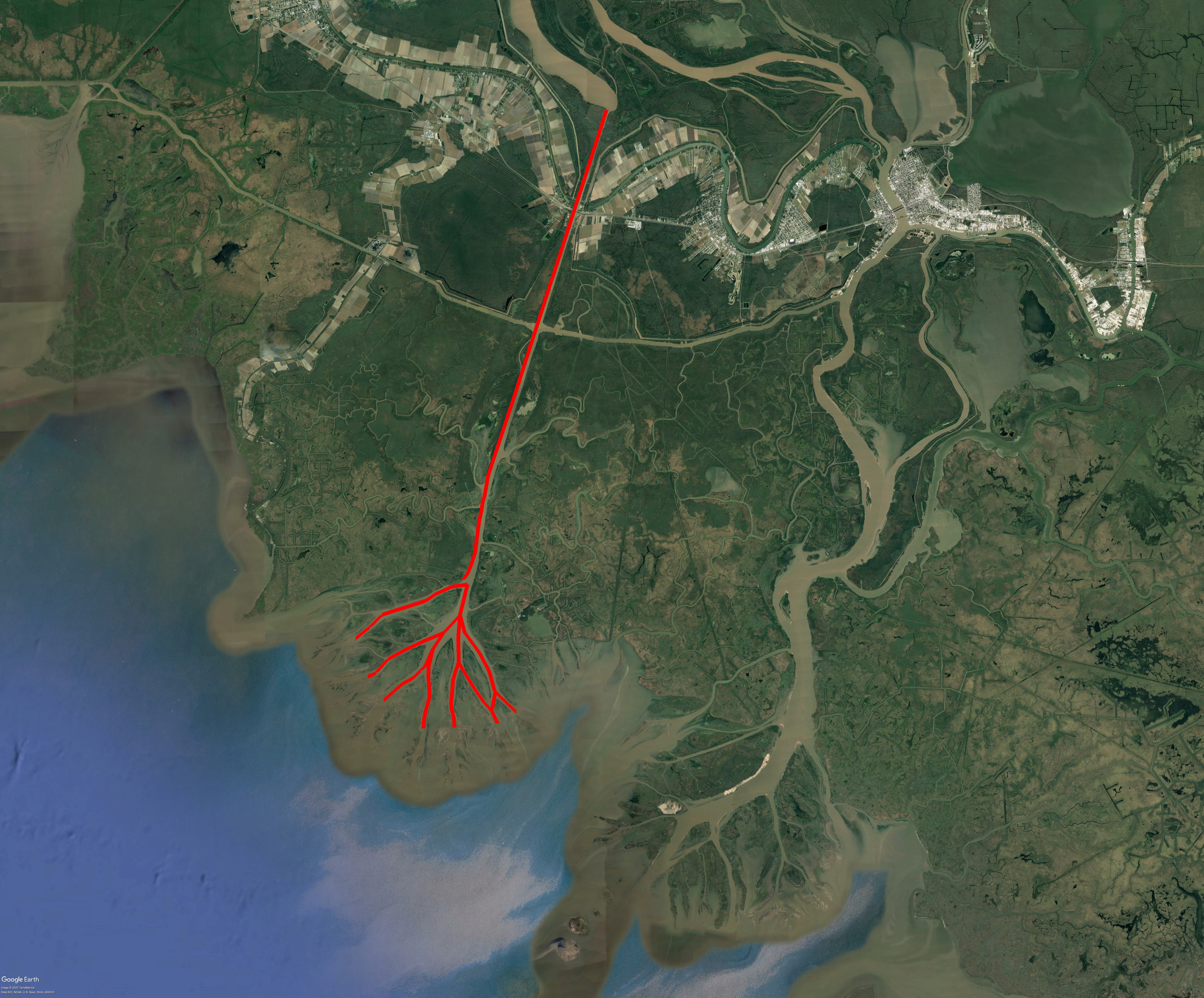
Pre-Delta-X: Water Levels across Wax Lake Outlet, Atchafalaya Basin, LA, USA, 2016
National Aeronautics and Space Administration —
This dataset provides absolute water level elevations derived for 10 locations across the Wax Lake Delta, Atchafalaya Basin, in Southern Louisiana, USA, within the... -
Federal
LBA-ECO CD-06 Isotopic Composition of Carbon Fractions, Amazon Basin River Water
National Aeronautics and Space Administration —
This data set includes measurements of standard geochemical variables, dissolved CO2, dissolved inorganic carbon (DIC), dissolved organic carbon (DOC), fine... -
Federal
LBA-ECO CD-06 Soil Classification Map, Ji-Parana River Basin, Rondonia, Brazil
National Aeronautics and Space Administration —
This data set provides a digital map of soil orders for the Ji-Parana River Basin, in the state of Rondonia, Brazil (Western Amazonia). Soil orders were manually... -
Federal
LBA-ECO LC-02 Tributary Coordinates, Acre River, Tri-national River Basin: 2003-2004
National Aeronautics and Space Administration —
This data set provides coordinates for points at the mouth of tributaries of the Acre River in the Tri-national River Basin in South America. Three Global Positioning... -
Federal
SAFARI 2000 Hydrographic Data, 1-Deg, Release 2.2 (Cogley)
National Aeronautics and Space Administration —
This southern African subset of the Global Hydrographic data set (GGHYDRO) Release 2.2 is organized into 19 files containing terrain type, stream frequency counts,... -
Federal
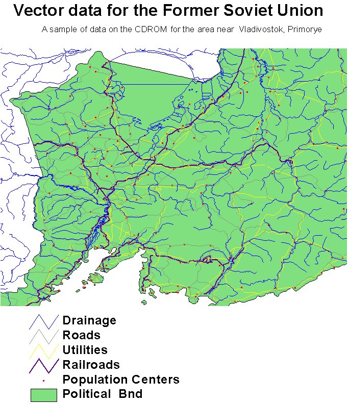
RLC Selected Infrastructure Data for the Former Soviet Union, 1993
National Aeronautics and Space Administration —
This data set consists of roads, drainage, railroads, utilities, and population center information in readily usable vector format for the land area of the Former... -
Federal
Pre-Delta-X: Lidar-derived Water Level Profiles in the Wax Lake Outlet, LA, USA, 2016
National Aeronautics and Space Administration —
This dataset contains lidar-derived water surface elevation profiles for river channels between Wax Lake, in the Atchafalaya River Basin of the Mississippi River... -
Federal
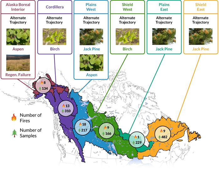
ABoVE: Synthesis of Post-Fire Regeneration Across Boreal North America
National Aeronautics and Space Administration —
This dataset is a synthesis of species-specific pre- and post-fire tree stem density estimates, field plot characterization data, and acquired climate moisture...

Official websites use .gov
A
.gov website belongs to an official government
organization in the United States.
Secure .gov websites use HTTPS
A
lock (
) or https:// means you’ve safely connected to
the .gov website. Share sensitive information only on official,
secure websites.