
-
Federal
PhenoCam Dataset v2.0: Digital Camera Imagery from the PhenoCam Network, 2000-2018
National Aeronautics and Space Administration —
This dataset provides a time series of visible-wavelength digital camera imagery collected through the PhenoCam Network at each of 393 sites predominantly in North... -
Federal
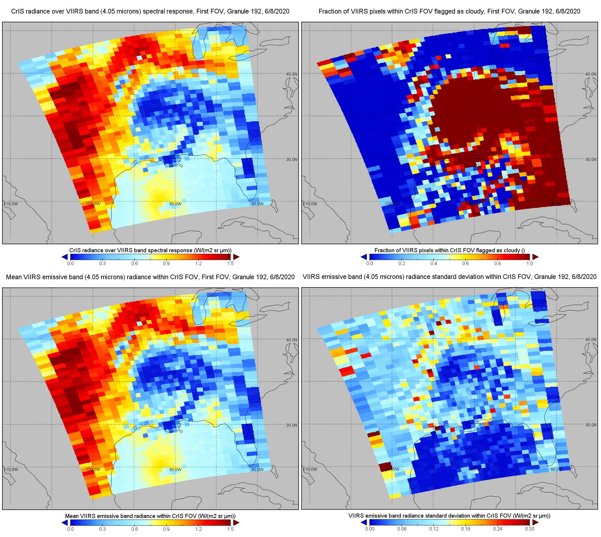
S-NPP CrIS IMG: Collocated VIIRS level 1 / cloud mask statistical summary V2 (SNDRSNCrISL1BIMG) at GES DISC
National Aeronautics and Space Administration —
The Cross-track Infrared Sounder (CrIS) Level 1B Normal Spectral Resolution (NSR) data files contain radiance measurements along with ancillary spacecraft,... -
Federal
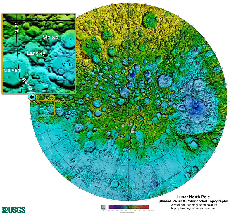
Gazetteer of Planetary Nomenclature: Moon: 1:10 million-scale Shaded Relief and Color-coded Topography: North Pole
National Aeronautics and Space Administration —
These lunar maps display the four different areas of the moon with color-coded topography in low and high resolution approved by the International Astronomical Union... -
Federal
JPSS-2 CrIS IMG_COL: Array indices for collocated VIIRS observations V3.0 (SNDRJ2CrISL1BIMGC) at GES DISC
National Aeronautics and Space Administration —
The Cross-track Infrared Sounder (CrIS) Level 1B Full Spectral Resolution (FSR) data files contain radiance measurements along with ancillary spacecraft, instrument,... -
Federal
VIIRS/NPP Burned Area Monthly L4 Global 500m SIN Grid V002
National Aeronautics and Space Administration —
The daily NASA/NOAA Suomi National Polar-orbiting Partnership (Suomi NPP) Visible Infrared Imaging Radiometer Suite (VIIRS) Burned Area (VNP64A1) Version 2 data... -
Federal
NASA Shuttle Radar Topography Mission Global 1 arc second number V003
National Aeronautics and Space Administration —
The Land Processes Distributed Active Archive Center (LP DAAC) is responsible for the archive and distribution of NASA Making Earth System Data Records for Use in... -
Federal
SAFARI 2000 ER-2 Color-IR Aerial Photography, Dry Season 2000
National Aeronautics and Space Administration —
Aerial photography from the NASA ER-2 high altitude aircraft was collected to provide detailed and spatially extensive documentation over parts of the SAFARI study... -
Federal
S-NPP CrIS IMG_COL: Array indices for collocated VIIRS observations V2 (SNDRSNCrISL1BIMGC) at GES DISC
National Aeronautics and Space Administration —
The Cross-track Infrared Sounder (CrIS) Level 1B Normal Spectral Resolution (NSR) data files contain radiance measurements along with ancillary spacecraft,... -
Federal
ECOSTRESS Gridded Evaporative Stress Index PT-JPL Instantaneous L4 Global 70 m V002
National Aeronautics and Space Administration —
The ECOsystem Spaceborne Thermal Radiometer Experiment on Space Station (ECOSTRESS) mission measures the temperature of plants to better understand how much water... -
Federal
Vegetation Index and Phenology (VIP) Vegetation Indices Daily Global 0.05Deg CMG V004
National Aeronautics and Space Administration —
The NASA Making Earth System Data Records for Use in Research Environments (MEaSUREs)... -
Federal
ASTER Global Digital Elevation Model V002
National Aeronautics and Space Administration —
The ASTGTM.002 dataset was decommissioned as of August 5, 2019. Users are encouraged to use the new improvedFederalLand Cover and Vegetation Map Collection for Seward Peninsula, Alaska
National Aeronautics and Space Administration —
This data set provides two landcover and vegetation maps for the Seward Peninsula, Alaska. These maps were produced from existing maps, Landsat imagery, and color...FederalVIIRS/NPP Thermal Anomalies and Fire Daily L3 Global 1km SIN Grid V001
National Aeronautics and Space Administration —
The daily NASA/NOAA Suomi National Polar-orbiting Partnership (Suomi NPP) Visible Infrared Imaging Radiometer Suite (VIIRS) Thermal Anomalies/Fire (VNP14A1) Version 1...FederalGlobal Soil Profile Data (ISRIC-WISE)
National Aeronautics and Space Administration —
The International Soil Reference and Information Centre-World Inventory of Soil Emission Potentials (ISRIC-WISE) international soil profile data set consists of a...FederalMISR Browse data V005
National Aeronautics and Space Administration —
This is the browse data associated with a particular granule. MISBR_005 is the Multi-angle Imaging SpectroRadiometer (MISR) Browse data version 5. It consists of...FederalAirborne Multi-angle Imaging SpectroRadiometer (AirMISR) Data from the CLAMS 2001 Campaign
National Aeronautics and Space Administration —
The AIRMISR_CLAMS_2001 data were acquired during the CLAMS campaign on July 12, July 17, August 1, and August 2 of 2001. The Jet Propulsion Laboratory (JPL) in...FederalAirborne Multi-angle Imaging SpectroRadiometer (AirMISR) Data from the Howland 2003 Campaign
National Aeronautics and Space Administration —
The AIRMISR_HOWLAND_2003 data were acquired during a field mission which overflew Howland Forest, Maine on August 28, 2003. The Jet Propulsion Laboratory (JPL) in...FederalS-MODE PRISM Level 1 Radiance and Ancillary Products Version 1
National Aeronautics and Space Administration —
This dataset contains PRISM data from the Sub-Mesoscale Ocean Dynamics Experiment (S-MODE) during the IOP1 campaign conducted approximately 300 km offshore of San...FederalS-MODE MASS Level 1 Hyperspectral Imagery Version 1
National Aeronautics and Space Administration —
This dataset contains airborne hyperspectral imagery from the Sub-Mesoscale Ocean Dynamics Experiment (S-MODE) during a pilot campaign conducted approximately 300 km...110 datasets found for "Color"

Official websites use .gov
A
.gov website belongs to an official government
organization in the United States.
Secure .gov websites use HTTPS
A
lock (
) or https:// means you’ve safely connected to
the .gov website. Share sensitive information only on official,
secure websites.