
-
Federal
Declassified Satellite Imagery 2 (2002)
National Aeronautics and Space Administration —
Declassified satellite images provide an important worldwide record of land-surface change. With the success of the first release of classified satellite photography... -
Federal
USGS High Resolution Orthoimagery
National Aeronautics and Space Administration —
High resolution orthorectified images combine the image characteristics of an aerial photograph with the geometric qualities of a map. An orthoimage is a uniform-... -
Federal
Milky Way Star Clusters Catalog
National Aeronautics and Space Administration —
Although they are the main constituents of the Galactic disk population, for half of the open clusters in the Milky Way reported in the literature nothing is known... -
Federal
Shuttle Radar Topography Mission (SRTM) Images
National Aeronautics and Space Administration —
Culminating more than four years of processing data, NASA and the National Geospatial-Intelligence Agency (NGA) have completed Earth's most extensive global... -
Federal
PhenoCam Dataset v2.0: Digital Camera Imagery from the PhenoCam Network, 2000-2018
National Aeronautics and Space Administration —
This dataset provides a time series of visible-wavelength digital camera imagery collected through the PhenoCam Network at each of 393 sites predominantly in North... -
Federal
Catalog of Galactic OB Stars
National Aeronautics and Space Administration —
An all-sky catalog of Galactic OB stars has been created by extending the Case-Hamburg Galactic Plane Luminous Stars surveys to include 5,500 additional objects drawn... -
Federal
Spitzer Atlas of Stellar Spectra Catalog
National Aeronautics and Space Administration —
The Spitzer Atlas of Stellar Spectra presents IRS Short-Low and Long-Low spectra of 159 stars selected to provide a complete sampling of the HR diagram. \n\nThe SASS... -
Federal
USGS Digital Orthophoto Quadrangles
National Aeronautics and Space Administration —
A Digital Orthophoto Quadrangle (DOQ) is a computer-generated image of an aerial photograph in which the image displacement caused by terrain relief and camera tilt... -
Federal
South Pole Telescope-Sunyarv-Zeldovich (SPT-SZ) Survey Catalog
National Aeronautics and Space Administration —
This table contains a catalog of galaxy clusters selected via their Sunyaev-Zel'dovich (SZ) effect signature from 2500 deg2 of South Pole Telescope (SPT) data. This... -
Federal
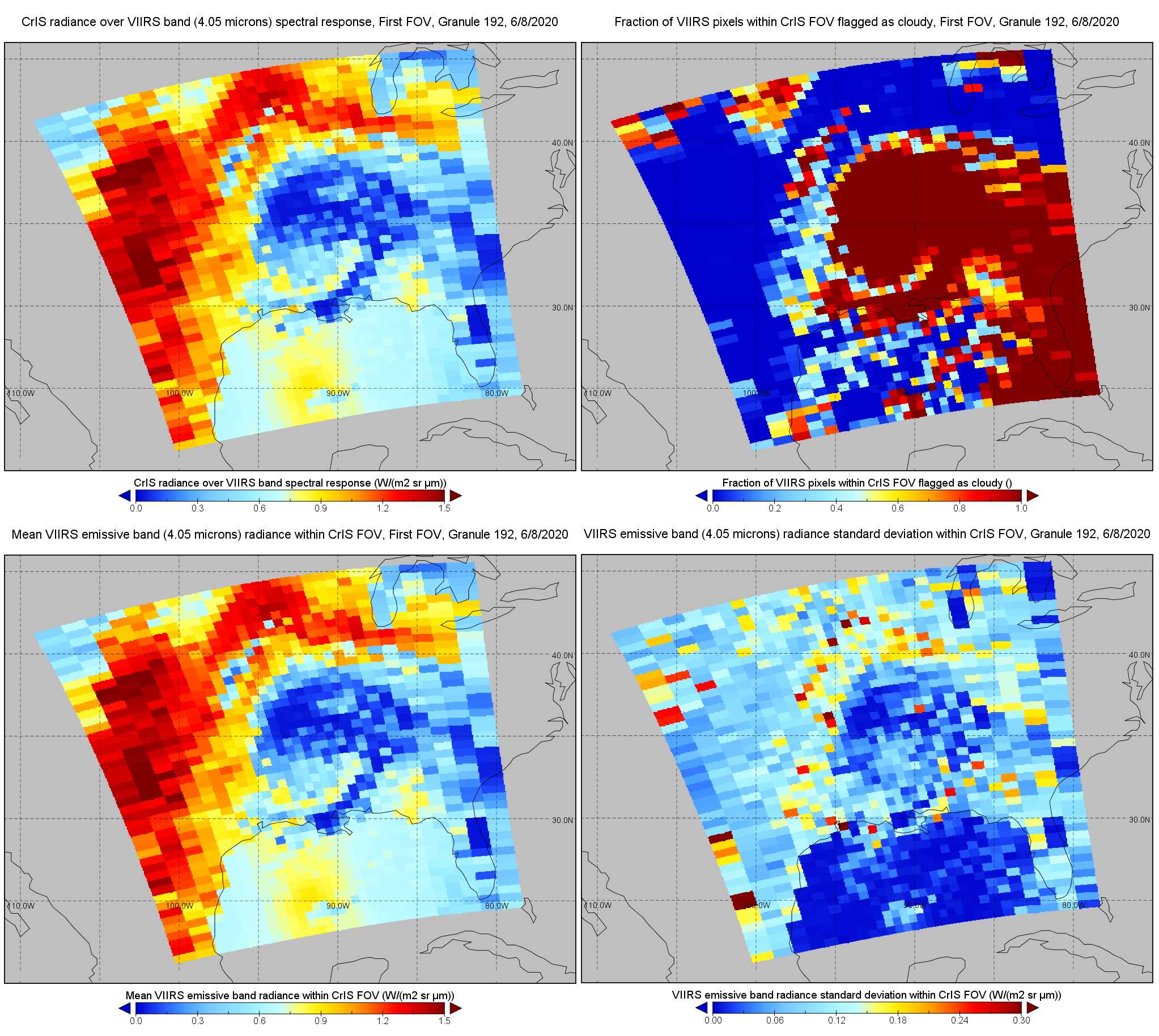
S-NPP CrIS IMG: Collocated VIIRS level 1 / cloud mask statistical summary V2 (SNDRSNCrISL1BIMG) at GES DISC
National Aeronautics and Space Administration —
The Cross-track Infrared Sounder (CrIS) Level 1B Normal Spectral Resolution (NSR) data files contain radiance measurements along with ancillary spacecraft,... -
Federal
Hipparcos Input Catalog
National Aeronautics and Space Administration —
This database table contains the Hipparcos Input Main Cataloge of 118209 stars. The Hipparcos Input Catalogue was constructed as the observing program for the... -
Federal
Lunar Sample Atlas
National Aeronautics and Space Administration —
The Lunar Sample Atlas provides pictures of the Apollo samples taken in the Lunar Sample Laboratory, full-color views of the samples in microscopic thin-sections,... -
Federal
Tycho-2 Catalog of the 2.5 Million Brightest Stars
National Aeronautics and Space Administration —
The Hipparcos and Tycho catalogs are the primary products of the European Space Agency's astrometric mission, Hipparcos. The satellite, which operated for four years,... -
Federal
GALEX/SDSS Quasar Catalog
National Aeronautics and Space Administration —
This table contains the result of an analysis of the broad-band UV and optical properties of z ~< 3.4 quasars matched in the Galaxy Evolution Explorer (GALEX)... -
Federal
Sentinel-3A OLCI Level-2 Earth-observation Reduced Resolution (ERR) Ocean Color (OC) - Near Real-time (NRT) Data, version R2022.0
National Aeronautics and Space Administration —
The Ocean Biology DAAC produces near real-time (quicklook) products using the best-available combination of ancillary data from meteorological and ozone data. As... -
Federal
Aqua MODIS Global Mapped Chlorophyll (CHL) - NRT Data, version R2022.0 NGDA
National Aeronautics and Space Administration —
The Ocean Biology DAAC produces near real-time (quicklook) products using the best-available combination of ancillary data from meteorological and ozone data. As... -
Federal
AllWISE Counterparts and Gaia Matches to ROSAT/2RXS X-Ray Sources
National Aeronautics and Space Administration —
This table contains the 132,254 AllWISE counterparts and/or Gaia matches to 106,573 X-ray sources detected in the ROSAT 2RXS survey with Galactic latitude |b| > 15... -
Federal
Aqua MODIS Level-3 Global Mapped 11µm Daytime Sea Surface Temperature (SST) Data, version R2019.0 NGDA
National Aeronautics and Space Administration —
MODIS (or Moderate-Resolution Imaging Spectroradiometer) is a key instrument aboard the Terra (EOS AM) and Aqua (EOS PM) satellites. Terra's orbit around the Earth is...

Official websites use .gov
A
.gov website belongs to an official government
organization in the United States.
Secure .gov websites use HTTPS
A
lock (
) or https:// means you’ve safely connected to
the .gov website. Share sensitive information only on official,
secure websites.