
-
Federal
Georeferenced Population Datasets of Mexico (GEO-MEX): GIS of Mexican States, Municipalities and Islands
National Aeronautics and Space Administration —
The GIS of Mexican States, Municipalities and Islands consists of attribute and boundary data for 1990. The attribute data include population, language, education,... -
Federal
HLS Sentinel-2 Multi-spectral Instrument Vegetation Indices Daily Global 30 m V2.0
National Aeronautics and Space Administration —
The Harmonized Landsat and Sentinel-2 (HLS) project provides consistent data products from the Operational Land Imager (OLI) aboard the joint NASA/USGS Landsat 8 and... -
Federal
Food Insecurity Hotspots Data Set
National Aeronautics and Space Administration —
The Food Insecurity Hotspots Data Set consists of grids at 250 meter (~7.2 arc-seconds) resolution that identify the level of intensity and frequency of food... -
Federal
Global Human Settlement Layer: Population and Built-Up Estimates, and Degree of Urbanization Settlement Model Grid
National Aeronautics and Space Administration —
The Global Human Settlement Layer: Population and Built-Up Estimates, and Degree of Urbanization Settlement Model Grid data set provides gridded data on human... -
Federal
MODIS/Terra+Aqua Land Cover Type Yearly L3 Global 500m SIN Grid V061
National Aeronautics and Space Administration —
The Terra and Aqua combined Moderate Resolution Imaging Spectroradiometer (MODIS) Land Cover Type (MCD12Q1) Version 6.1 data product provides global land cover types... -
Federal
Global Soil Types, 0.5-Degree Grid (Modified Zobler)
National Aeronautics and Space Administration —
A global data set of soil types is available at 0.5-degree latitude by 0.5-degree longitude resolution. There are 106 soil units, based on Zobler?s (1986) assessment... -
Federal
BOREAS CanSIS Regional Soils Data in Vector Format, V2
National Aeronautics and Space Administration —
This data set contains soils data from the Canada Soil Information System (CanSIS) in ESRI Shapefile format for the provinces of Saskatchewan and Manitoba. They are... -
Federal
Headwall Hyperspectral Reflectance LTER Cedar Creek Minnesota Multi-Year 1 mm
National Aeronautics and Space Administration —
The Headwall Hyperspectral Reflectance data are for the Long-Term Ecological Research (LTER) at Cedar Creek Ecosystem Science Reserve (CCESR), Minnesota... -
Federal
Classification of Global Forests for IPCC Aboveground Biomass Tier 1 Estimates, 2020
National Aeronautics and Space Administration —
This dataset provides classes of global forests delineated by status/condition in 2020 at approximately 30-m resolution. The data support generating Tier 1 estimates... -
Federal
SWOT Level 2 Water Mask Pixel Cloud Data Product, Version D
National Aeronautics and Space Administration —
The SWOT Level 2 Water Mask Pixel Cloud Product (SWOT_L2_HR_PIXC_D) provides high-resolution, geolocated observations of terrestrial surface water pixels detected by... -
Federal
ABoVE: Boreal Forest Resilience Study 2020-2022, Fairbanks AK
National Aeronautics and Space Administration —
This dataset includes five metrics of forest resilience (recruitment, invasives, permafrost change, tree damage, and radial growth) at five recently burned forest... -
Federal
MODIS/Terra+Aqua Downward Shortwave Radiation Daily/3-Hour L3 Global 0.05Deg CMG V062
National Aeronautics and Space Administration —
The MCD18C1 Version 6.2 is a Moderate Resolution Imaging Spectroradiometer (MODIS) Terra and Aqua combined Downward Shortwave Radiation (DSR) Level 3 product produced... -
Federal
MiCASA Daily NPP Rh ATMC NEE FIRE FUEL Fluxes 0.1 degree x 0.1 degree
National Aeronautics and Space Administration —
MiCASA is an extensive revision of CASA-GFED3. CASA-GFED3 derives from Potter et al. (1993), diverging in development since Randerson et al. (1996). CASA is a light... -
Federal
Low Elevation Coastal Zone (LECZ) Urban-Rural Population and Land Area Estimates, Version 3
National Aeronautics and Space Administration —
The Low Elevation Coastal Zone (LECZ) Urban-Rural Population and Land Area Estimates, Version 3 data set contains land areas with urban, quasi-urban, rural, and total... -
Federal
MODIS/Terra+Aqua Land Cover Type Yearly L3 Global 500m SIN Grid V006
National Aeronautics and Space Administration —
The MCD12Q1 Version 6 data product was decommissioned on July 31, 2023. Users are encouraged to use the MCD12Q1... -
Federal
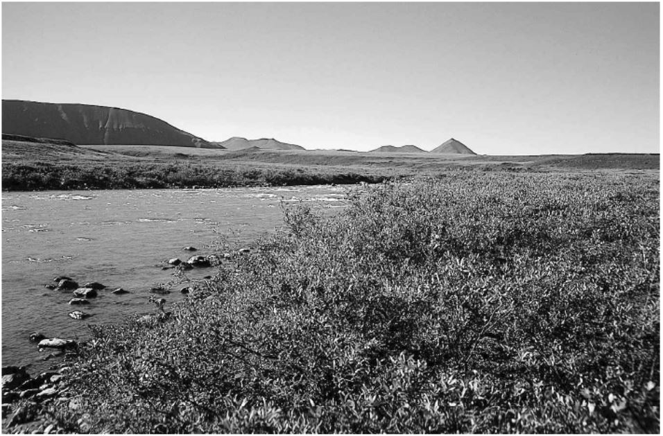
Arctic Vegetation Plots in Willow Communities, North Slope, Alaska, 1997
National Aeronautics and Space Administration —
This data set provides environmental, soil, and vegetation data collected in July and August 1997 from 85 study plots in willow shrub communities located along a... -
Federal
Annual Land Use and Urban Land Cover: Ethiopia, Nigeria, and South Africa, 2016-2020
National Aeronautics and Space Administration —
This dataset provides a two-tier annual Land Use (LU) and Urban Land Cover (LC) product suite over three African countries, Ethiopia, Nigeria, and South Africa,... -
Federal
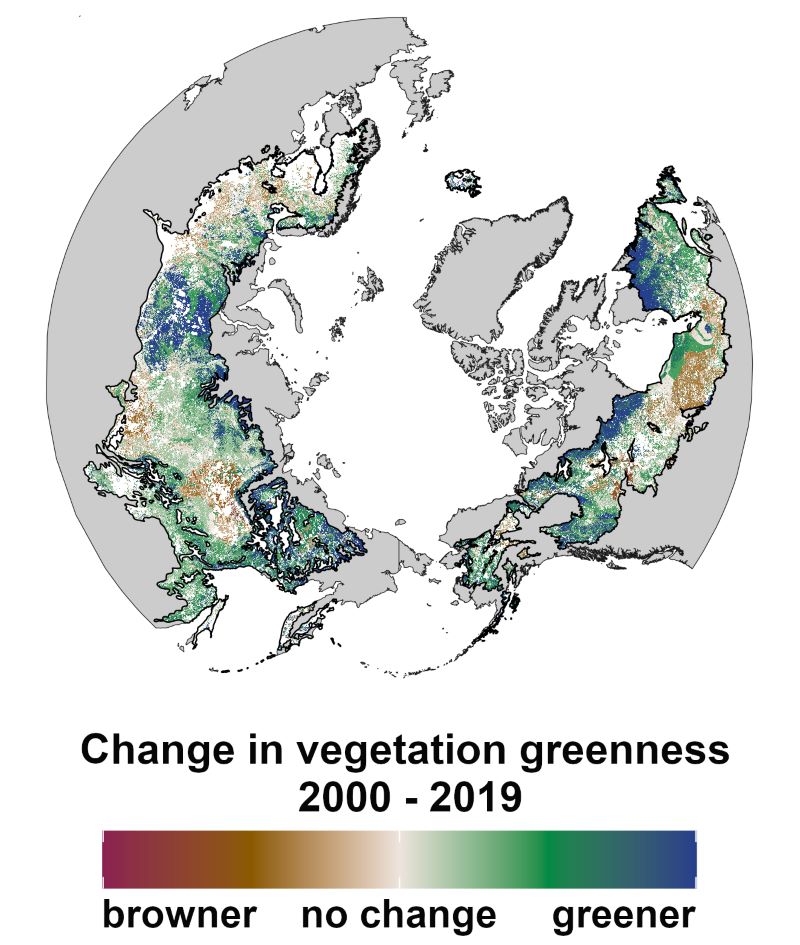
ABoVE: Landsat Vegetation Greenness Trends, Boreal Forest Biome, 1985-2019
National Aeronautics and Space Administration —
This dataset provides information on interannual trends in annual maximum vegetation greenness from 1985 to 2019 for recently undisturbed areas in the boreal forest... -
Federal
ABoVE: Characterization of Carbon Dynamics in Burned Forest Plots, NWT, Canada, 2014
National Aeronautics and Space Administration —
This dataset provides field data from boreal forests in the Northwest Territories (NWT), Canada, that were burned by wildfires in 2014. During fieldwork in 2015, 211... -
Federal
MODIS/Terra Land Water Mask Derived from MODIS and SRTM L3 Global 250m SIN Grid V061
National Aeronautics and Space Administration —
The Terra Moderate Resolution Imaging Spectroradiometer (MODIS) Land Water Mask (MOD44W) Version 6.1 data product provides a global map of surface water at 250 meter...

Official websites use .gov
A
.gov website belongs to an official government
organization in the United States.
Secure .gov websites use HTTPS
A
lock (
) or https:// means you’ve safely connected to
the .gov website. Share sensitive information only on official,
secure websites.