
-
Federal
Aviation Safety Reporting System: Bird or Animal Strike Reports
National Aeronautics and Space Administration —
A sampling of reports referencing a bird or animal strike incident. -
Federal
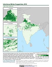
India Annual Winter Cropped Area, 2001-2016 NGDA
National Aeronautics and Space Administration —
The India Annual Winter Cropped Area, 2001 - 2016 consists of annual winter cropped areas for most of India (except the Northeastern states) from 2000-2001 to... -
Federal
Local Observations from the Seasonal Ice Zone Observing Network (SIZONet) and Alaska Arctic Observatory and Knowledge Hub (AAOKH), Version 2
National Aeronautics and Space Administration —
The Seasonal Ice Zone Observing Network (SIZONet) and the Alaska Arctic Observatory and Knowledge Hub (AAOKH) share the Local Observations Interface, which allows... -
Federal
Sea Ice in the Belcher Islands, Nunavut, Canada, Version 1
National Aeronautics and Space Administration —
This data set contains interviews of three hunters from Sanikiliaq, Belcher Islands, in the territory of Nunavut, Canada. The hunters describe their observations of... -
Federal
Design of heavy lift cargo aircraft
National Aeronautics and Space Administration —
This is the bird of the skies of the future. The heavy lift cargo aircraft which is currently being developed by me has twice the payload capacity of an Antonov A-225... -
Federal
BioSCape: BioSoundSCape Acoustic Recordings, South Africa, 2023
National Aeronautics and Space Administration —
This dataset holds in situ sound recordings from sites in Greater Cape Floristic Region (GCFR), South Africa from June to December 2023. The recordings were collected... -
Federal
High-Resolution QuickBird Imagery and Related GIS Layers for Barrow, Alaska, USA, Version 1
National Aeronautics and Space Administration —
This data set contains high-resolution QuickBird imagery and geospatial data for the entire Barrow QuickBird image area (156.15° W - 157.07° W, 71.15° N - 71.41° N)... -
Federal
TRMM Ground Validation Calibrated QC Radar Reflectivity Full Volume Scan L1C 1 hour V7 (TRMM_1C51) at GES DISC
National Aeronautics and Space Administration —
The purpose of the 1C51 algorithm is to remove non-meteorological radar echoes that adversely affect the quality of higher level products, such as clutter associated... -
Federal
QuickBird Level 1B Panchromatic Satellite Imagery
National Aeronautics and Space Administration —
The QuickBird Panchromatic Imagery collection contains satellite imagery acquired from Maxar Technologies by the Commercial Smallsat Data Acquisition (CSDA) Program.... -
Federal
Reduced-Resolution QuickBird Imagery and Related GIS Layers for Barrow, Alaska, USA, Version 1
National Aeronautics and Space Administration —
This data set contains reduced-resolution QuickBird imagery and geospatial data for the entire Barrow QuickBird image area 156.15° W - 157.07° W, 71.15° N - 71.41° N)... -
Federal
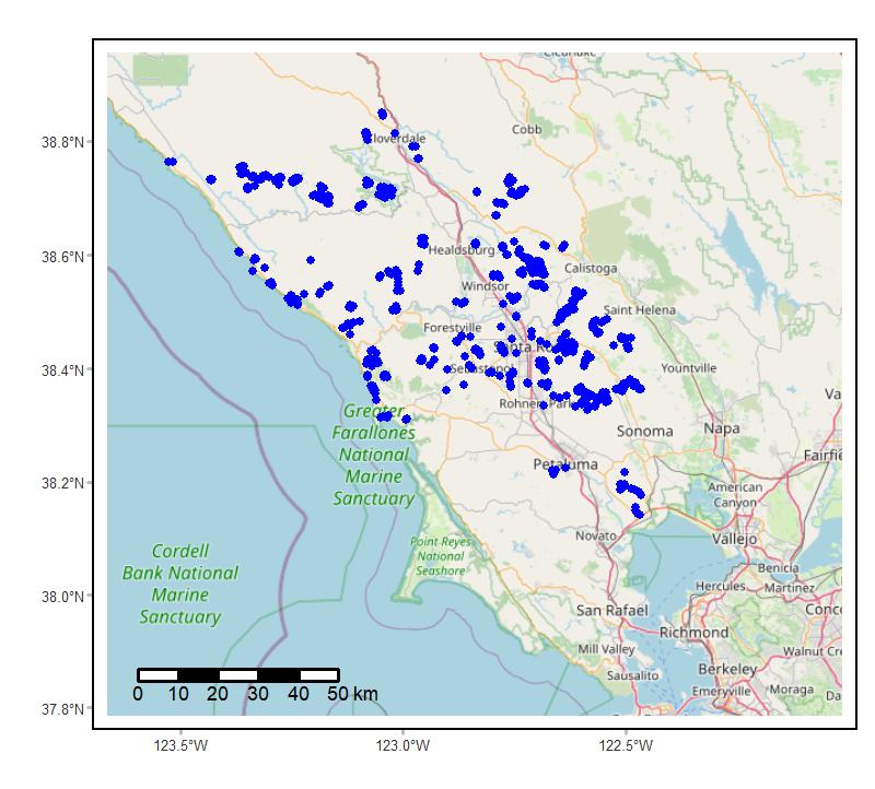
Soundscapes to Landscapes Acoustic Recordings, Sonoma County, CA, 2017-2022
National Aeronautics and Space Administration —
This dataset holds in situ sound recordings from sites in Sonoma County, California, USA as part of the Soundscapes to Landscapes citizen science project. Recordings... -
Federal
Natural Resources Conservation Service SD State Farm Service Agency Color Slide Scans
National Aeronautics and Space Administration —
The unique landscape of South Dakota, known for its diverse wetlands and large areas of native prairie, provides critical habitat for many of the nation’s migratory... -
Federal
Summary Report of Community-Based Environmental and Species Observations from the Bering Sea Sub-Network, 2008-2009, Version 1
National Aeronautics and Space Administration —
The Bering Sea Sub-Network (BSSN) is comprised of a set of coastal communities representing six indigenous cultures: three in the Russian Federation and three in the... -
Federal
High-Resolution Rectified Aerial Photography for Collaborative Research of Environmental Change at Barrow, Alaska, USA, Version 1
National Aeronautics and Space Administration —
This data set includes aerial photography of Barrow, Alaska, which has been geocorrected to a 2002 QuickBird satellite image or Interferometric Synthetic Aperture... -
Federal
QuickBird Level 1B Multispectral 4-Band Satellite Imagery
National Aeronautics and Space Administration —
The QuickBird Level 1B Multispectral 4-Band Imagery collection contains satellite imagery acquired from Maxar Technologies by the Commercial Smallsat Data Acquisition... -
Federal
TRMM Ground Validation Calibrated QC Radar Reflectivity Full Volume Scan L1C 1 hour V7 (TRMM_1C51UW) at GES DISC
National Aeronautics and Space Administration —
This dataset is part of the University of Washington TRMM Ground Validation products. Files are in "Universal Format", described in BAMS, Vol 61, No 11, November... -
Federal
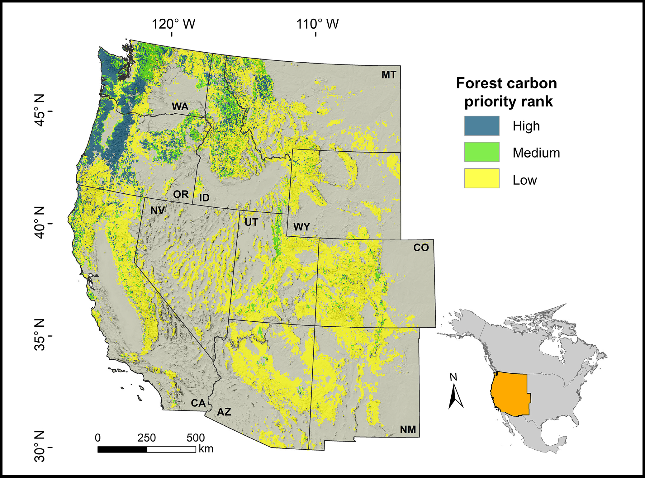
Forest Preservation Ranking and Vertebrate Species Richness, Western USA, 2020-2099
National Aeronautics and Space Administration —
This dataset provides related gridded outputs of future modeled forest carbon sequestration priority and related species richness and habitat suitability for the... -
Federal
INTEGRAL IBIS AGN Catalog
National Aeronautics and Space Administration —
In this work, the authors present the most comprehensive INTEGRAL active galactic nucleus (AGN) sample. It lists 272 AGN for which they have secure optical... -
Federal
Radiant Temp. Multiangle Data (FIFE)
National Aeronautics and Space Administration —
The Surface Temperatures Measured at Multiple Angles Data Set was collected at two locations within the northwest quadrant of the FIFE study area during July and...

Official websites use .gov
A
.gov website belongs to an official government
organization in the United States.
Secure .gov websites use HTTPS
A
lock (
) or https:// means you’ve safely connected to
the .gov website. Share sensitive information only on official,
secure websites.