
-
Federal
SARP 2012 Data
National Aeronautics and Space Administration —
SARP_2012_Data is the data collected onboard the NASA P-3B aircraft during the 2012 deployment of the Student Airborne Research Program (SARP) mission. Data... -
Federal
SHIFT: AVIRIS-NG Full-Resolution True Color Images
National Aeronautics and Space Administration —
This dataset holds full-resolution 3-band (true color) imagery acquired by NASA's Airborne Visible / Infrared Imaging Spectrometer-Next Generation (AVIRIS-NG)... -
Federal
NASA Life Sciences Portal (NLSP)
National Aeronautics and Space Administration —
The NASA Life Sciences Portal (NLSP) is the data platform for accessing NASA's Life Sciences Data Archive (LSDA). The LSDA is an active archive that provides... -
Federal
Global Gridded Soil Phosphorus Distribution Maps at 0.5-degree Resolution
National Aeronautics and Space Administration —
This data set provides estimates of different forms of naturally occurring soil phosphorus (P) including labile inorganic P, organic P, occluded P, secondary mineral... -
Federal
Arctic Vegetation Plots for IBP Tundra Biome, Barrow, Alaska, 1972-2010
National Aeronautics and Space Administration —
This data set provides vegetation cover and environmental plot data collected as part of the International Biological Program (IBP), U. S. Tundra Biome Program, in... -
Federal
SARP 2019 Data
National Aeronautics and Space Administration —
SARP_2019_Data is the data collected onboard the NASA DC-8 aircraft during the 2019 deployment of the Student Airborne Research Program (SARP) mission. Data... -
Federal
Gene expression profiling of C. elegans under various thermal conditions
National Aeronautics and Space Administration —
To realistically evaluate the effects of the environment in space it is necessary to understand the effects of external factors during sample transport from Earth to... -
Federal
Rodent Research-1 (RR1) NASA Validation Flight: Mouse tibialis anterior muscle transcriptomic proteomic and epigenomic data
National Aeronautics and Space Administration —
NASA s Rodent Research (RR) project is playing a critical role in advancing biomedical research on the physiological effects of space environments. Due to the limited... -
Federal
SHIFT: Wetland Spectra, Salinity, and Fractional Cover, Devereux Slough, CA, 2022
National Aeronautics and Space Administration —
This dataset includes field data, analysis code, and corresponding airborne imagery collected and generated during the 2022 NASA Surface Biology Geology (SBG) High... -
Federal
NASA Ocean Biogeochemical Model assimilating satellite chlorophyll data global monthly VR2017 (NOBM_MON) at GES DISC
National Aeronautics and Space Administration —
This is the assimilated monthly data from NASA Ocean Biogeochemical Model (NOBM). The NOBM is a comprehensive, interactive ocean biogeochemical model coupled with a... -
Federal
NOAA-20 VIIRS Global Mapped Inherent Optical Properties (IOP) - Near Real-time (NRT) Data, version R2022.0
National Aeronautics and Space Administration —
The Ocean Biology DAAC produces near real-time (quicklook) products using the best-available combination of ancillary data from meteorological and ozone data. As... -
Federal
NOAA-20 VIIRS Global Mapped Particulate Organic Carbon (POC) - Near Real Time (NRT) Data, version R2022.0
National Aeronautics and Space Administration —
The Ocean Biology DAAC produces near real-time (quicklook) products using the best-available combination of ancillary data from meteorological and ozone data. As... -
Federal
SCICEX: Submarine Arctic Science Program, Version 1
National Aeronautics and Space Administration —
The Submarine Arctic Science Program, SCICEX, is a federal interagency collaboration among the operational Navy, research agencies, and the marine research community... -
Federal
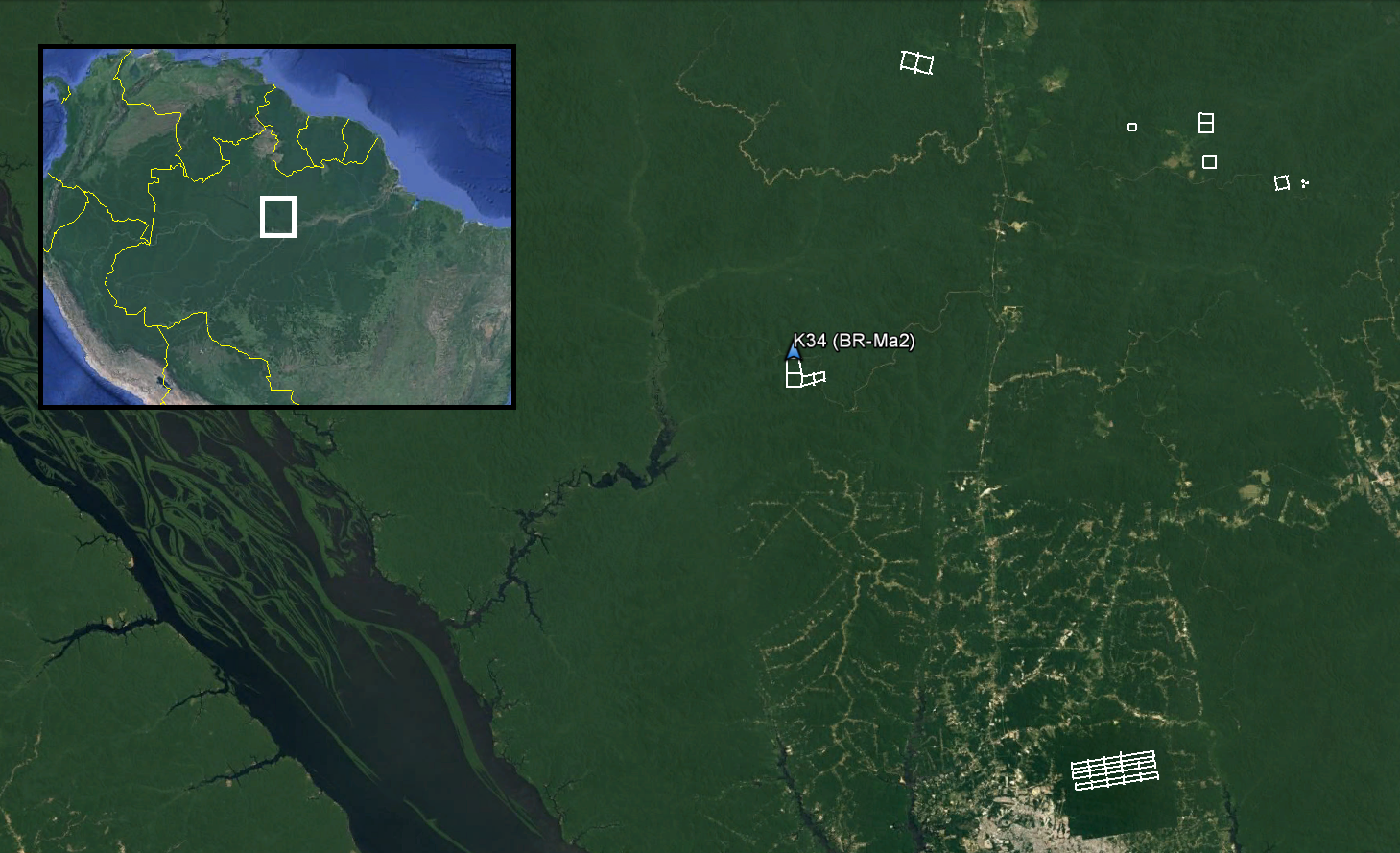
LiDAR and DTM Data from Forested Land Near Manaus, Amazonas, Brazil, 2008
National Aeronautics and Space Administration —
This data set provides LiDAR point clouds and digital terrain models (DTM) from surveys over the K34 tower site in the Cuieiras Biological Reserve, over forest... -
Federal
Terra MODIS Global Mapped Particulate Organic Carbon (POC) - Near Real Time (NRT) Data, version R2022.0 NGDA
National Aeronautics and Space Administration —
The Ocean Biology DAAC produces near real-time (quicklook) products using the best-available combination of ancillary data from meteorological and ozone data. As... -
Federal
Suomi-NPP VIIRS Regional Inherent Optical Properties (IOP) - Near Real-time (NRT) Data, version R2022.0
National Aeronautics and Space Administration —
The Ocean Biology DAAC produces near real-time (quicklook) products using the best-available combination of ancillary data from meteorological and ozone data. As... -
Federal
NOAA-21 VIIRS Global Mapped Chlorophyll (CHL) - NRT Data, version R2022.0
National Aeronautics and Space Administration —
The Ocean Biology DAAC produces near real-time (quicklook) products using the best-available combination of ancillary data from meteorological and ozone data. As... -
Federal
SHIFT: AVIRIS-NG L2A Unrectified Surface Reflectance Version 1
National Aeronautics and Space Administration —
This dataset contains Level 2A (L2A) unrectified surface reflectance images from NASA's Airborne Visible / Infrared Imaging Spectrometer-Next Generation (AVIRIS-NG)...

Official websites use .gov
A
.gov website belongs to an official government
organization in the United States.
Secure .gov websites use HTTPS
A
lock (
) or https:// means you’ve safely connected to
the .gov website. Share sensitive information only on official,
secure websites.