
-
Federal
GPM IMERG Final Precipitation L3 1 day 0.1 degree x 0.1 degree V07 (GPM_3IMERGDF) at GES DISC
National Aeronautics and Space Administration —
Version 07 is the current version of the data set. Older versions will no longer be available and have been superseded by Version 07.The Integrated Multi-satellitE... -
Federal
Daymet: Daily Surface Weather Data on a 1-km Grid for North America, Version 4 R1
National Aeronautics and Space Administration —
This dataset provides Daymet Version 4 R1 data as gridded estimates of daily weather parameters for North America, Hawaii, and Puerto Rico. Daymet variables include... -
Federal
AQUA MODIS High Resolution Level 3 daily aerosol data, 0.1x0.1 degree grid Version 001 (AER_DBDT_D10KM_L3_MODIS_AQUA) at GES DISC
National Aeronautics and Space Administration —
This High-Resolution (0.1 x 0.1 degree) Level 3 daily Aerosol Optical Depth (AOD) product is generated by combining two Moderate Resolution Imaging Spectroradiometer... -
Federal
MLS/Aura Level 2 Sulfur Dioxide (SO2) Mixing Ratio V005 (ML2SO2) at GES DISC
National Aeronautics and Space Administration —
ML2SO2 is the EOS Aura Microwave Limb Sounder (MLS) standard product for sulfur dioxide derived from radiances measured by the 240 GHz radiometer. The data version is... -
Federal
GEOS-Carb CASA-GFED Daily Fire and Fuel Emissions 0.5 degree x 0.5 degree V3 (GEOS_CASAGFED_D_FIRE) at GES DISC
National Aeronautics and Space Administration —
This product provides Daily average wildfire emissions (FIRE) andfuel wood burning emissions (FUEL) derived from the Carnegie-Ames-Stanford-Approach – Global Fire... -
Federal
Annual Summary of Artificial Light At Night from VIIRS/S-NPP at CONUS County and Census Tract V1 (ALAN_VIIRS_CONUS) at GES DISC
National Aeronautics and Space Administration —
This product provides detailed information about the satellite-based data on artificial light at night (ALAN). The Suomi National Polar-orbiting Partnership (S-NPP)... -
Federal
HAQAST Sentinel-5P TROPOMI Nitrogen Dioxide (NO2) GLOBAL Annual Level 3 0.1 x 0.1 Degree Gridded Data Version 2.4 (HAQ_TROPOMI_NO2_GLOBAL_A_L3) at GES DISC
National Aeronautics and Space Administration —
This product provides level 3 annual averages of tropospheric Nitrogen dioxide (NO2) vertical column density derived from the level 2 Tropospheric Monitoring... -
Federal
OMPS-NPP L2 LP Aerosol Extinction Vertical Profile swath daily 3slit V2.5 (OMPS_NPP_LP_L2_AER_DAILY) at GES DISC
National Aeronautics and Space Administration —
The OMPS-NPP L2 LP Aerosol Extinction Vertical Profile swath daily 3slit (AER) product contains the retrieved aerosol extinction coefficients measured by the Ozone... -
Federal
Sentinel-5P TROPOMI Methane CH4 1-Orbit L2 7km x 7km V1 (S5P_L2__CH4___) at GES DISC
National Aeronautics and Space Administration —
Starting from August 6th in 2019, Sentinel-5P TROPOMI along-track high spatial resolution (~5.5km at nadir) has been implemented. For data after August 6th of 2019,... -
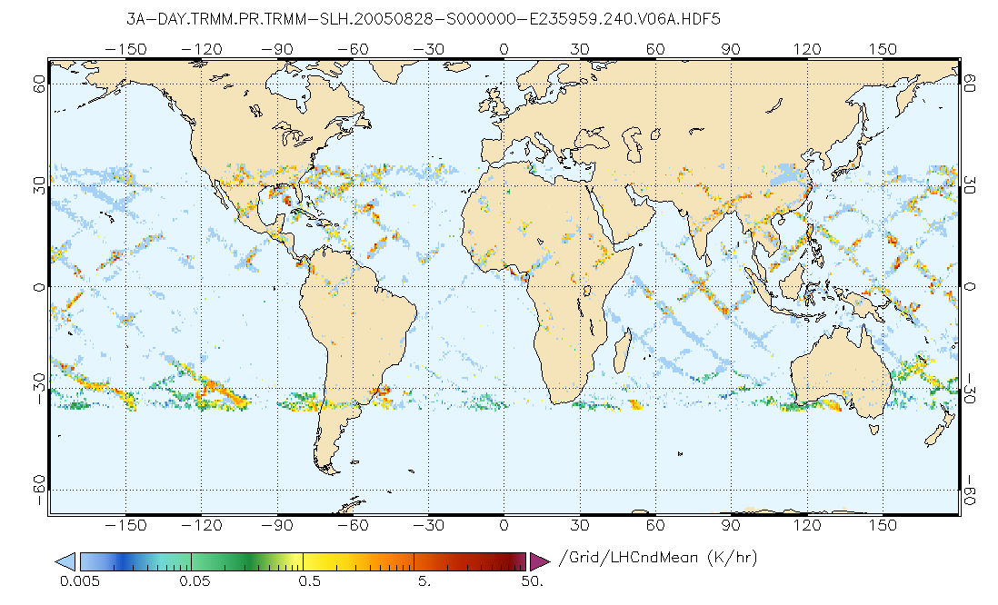
Federal
GPM PR on TRMM Spectral Latent Heating Profiles L3 1 Day 0.5x0.5 degree V07 (GPM_3HSLH_TRMM_DAY) at GES DISC
National Aeronautics and Space Administration —
This a new (GPM-formated) TRMM product. There is no equivalent in the old TRMM suite of products.Version 07 is the current version of the data set. Older versions... -
Federal
TERRA MODIS High Resolution Level 3 daily aerosol data, 0.1x0.1 degree grid Version 001 (AER_DBDT_D10KM_L3_MODIS_TERRA) at GES DISC
National Aeronautics and Space Administration —
This High-Resolution (0.1 x 0.1 degree) Level 3 daily Aerosol Optical Depth (AOD) product is generated by combining two Moderate Resolution Imaging Spectroradiometer... -
Federal
NACP Regional: National Greenhouse Gas Inventories and Aggregated Gridded Model Data
National Aeronautics and Space Administration —
This data set provides two products that were derived from the recently published North American Carbon Program (NACP) Regional Synthesis 1-degree terrestrial... -
Federal
ECOSTRESS Gridded Downscaled Meteorology Instantaneous L3 Global 70 m V002
National Aeronautics and Space Administration —
The ECOsystem Spaceborne Thermal Radiometer Experiment on Space Station (ECOSTRESS) mission measures the temperature of plants to better understand how much water... -
Federal
OMI/Aura Nitrogen Dioxide (NO2) Total and Tropospheric Column 1-orbit L2 Swath 13x24 km V004 (OMNO2) at GES DISC
National Aeronautics and Space Administration —
The Collection 4, Version 5.0, Aura Ozone Monitoring Instrument (OMI) Nitrogen Dioxide (NO2) Standard Product (OMNO2) is now available from the NASA Goddard Earth... -
Federal
ATom: Merged Atmospheric Chemistry, Trace Gases, and Aerosols, Version 2
National Aeronautics and Space Administration —
This dataset provides information on greenhouse gases and human-produced air pollution, including atmospheric concentrations of carbon dioxide (CO2), methane (CH4),... -
Federal
MRIR/Nimbus-3 Images of Daytime Brightness Temperature on 4 x 5 inch Film Sheets V001 (MRIRN3IM) at GES DISC
National Aeronautics and Space Administration —
MRIRN3IM is the Nimbus-3 Medium Resolution Infrared Radiometer (MRIR) data product consisting of 4 x 5 inch photographic film sheets. Each film sheet contains an... -
Federal
GPM AMSU-B on NOAA 16 Common Calibrated Brightness Temperatures L1C 1.5 hours 16 km V07 (GPM_1CNOAA16AMSUB) at GES DISC
National Aeronautics and Space Administration —
Version 07 is the current version of the data set. Older versions will no longer be available and have been superseded by Version 07.All 1C products have a common L1C... -
Federal
GPM SSMIS on F16 (GPROF) Climate-based Radiometer Precipitation Profiling L3 1 month 0.25 degree x 0.25 degree V07 (GPM_3GPROFF16SSMIS_CLIM) at GES DISC
National Aeronautics and Space Administration —
Version 07 is the current version of the data set. Older versions will no longer be available and have been superseded by Version 07. The "CLIM" products differ from... -
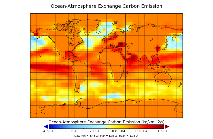
Federal
Carbon Monitoring System Flux for Ocean Carbon L4 V1 (CMSFluxOcean) at GES DISC
National Aeronautics and Space Administration —
This dataset provides the Carbon Flux for Ocean Carbon.The NASA Carbon Monitoring System (CMS) is designed to make significant contributions in characterizing,... -
Federal
MLS/Aura Level 3 Daily Binned Geopotential Height (GPH) on Zonal and Similar Grids V005 (ML3DZGPH) at GES DISC
National Aeronautics and Space Administration —
ML3DZGPH is the EOS Aura Microwave Limb Sounder (MLS) daily binned on zonal and assorted vertical grids product for geopotential height (GPH) derived from radiances...

Official websites use .gov
A
.gov website belongs to an official government
organization in the United States.
Secure .gov websites use HTTPS
A
lock (
) or https:// means you’ve safely connected to
the .gov website. Share sensitive information only on official,
secure websites.