

11 datasets found for "96b텔레RADARDB$ㅣ실시간디비상담☑️"
-
Federal
Global Landslide Catalog Export
National Aeronautics and Space Administration —
The Global Landslide Catalog (GLC) was developed with the goal of identifying rainfall-triggered landslide events around the world, regardless of size, impacts or... -
Federal
Testing Now
National Aeronautics and Space Administration —
A test dataset for Socrata help ticket -
Federal
RapidScat Level 2B Ocean Wind Vectors in 12.5km Slice Composites Version 1.1
National Aeronautics and Space Administration —
This dataset contains the RapidScat Level 2B 12.5km Version 1.1 science-quality ocean surface wind vectors. The Level 2B wind vectors are binned on a 12.5 km Wind... -
Federal
NACP Integrated Wildland and Cropland 30-m Fuel Characteristics Map, U.S.A., 2010
National Aeronautics and Space Administration —
The data set provides a 30-m comprehensive fuelbed characteristics map for both the wildland and cropland areas of the conterminous United States (CONUS) for 2010.... -
Federal
GFZ TELLUS GRACE Level-3 Monthly Land Water-Equivalent-Thickness Surface Mass Anomaly Release 6.0 version 04
National Aeronautics and Space Administration —
The monthly land mass grids contain water mass anomalies given as equivalent water thickness derived from GRACE & GRACE-FO time-variable gravity observations... -
Federal
Western North American FLEXPART Back Trajectory 2013 Data
National Aeronautics and Space Administration —
WNA-FLEXPART-BackTraj-2013 is the 2013 Western North America Back Trajectory data using the FLEXible PARTicle (FLEXPART) dispersion model. Data collection for this... -
Federal
Western North American FLEXPART Back Trajectory 2004 Data
National Aeronautics and Space Administration —
WNA-FLEXPART-BackTraj-2004 is the 2004 Western North America Back Trajectory data using the FLEXible PARTicle (FLEXPART) dispersion model. Data collection for this... -
Federal
Western North American FLEXPART Back Trajectory 2006 Data
National Aeronautics and Space Administration —
WNA-FLEXPART-BackTraj-2006 is the 2006 Western North America Back Trajectory data using the FLEXible PARTicle (FLEXPART) dispersion model. Data collection for this... -
Federal
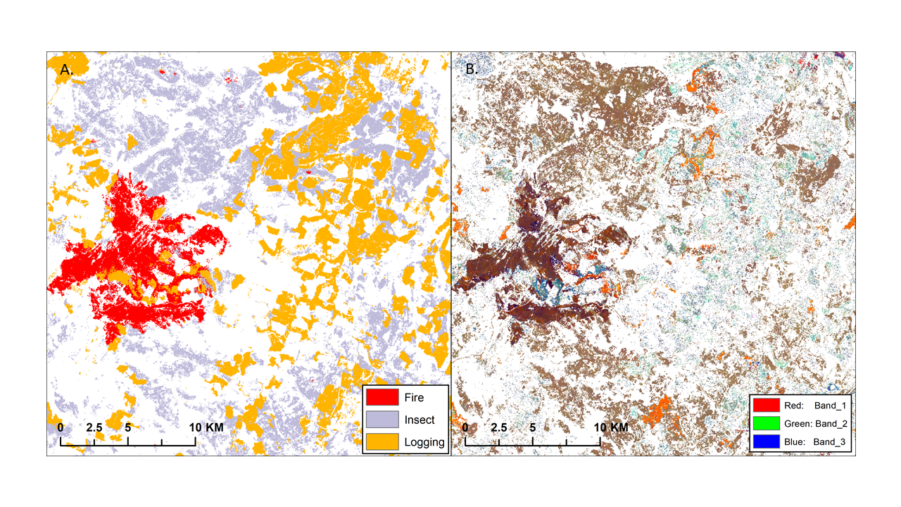
ABoVE: Landsat-derived Annual Disturbance Agents Across ABoVE Core Domain, 1987-2012
National Aeronautics and Space Administration —
This dataset provides spatial data on disturbance agents of fire, insects, and logging in the Arctic Boreal Vulnerability Experiment (ABoVE) core domain at an annual... -
Federal
NACP MCI: CO2 Flux from Inversion Modeling, Upper Midwest Region, USA, 2007
National Aeronautics and Space Administration —
This data set provides estimates of Net Ecosystem Exchange (NEE) flux for the U.S. Upper Midwest at 0.5-degree resolution for the year 2007. Estimates were produced... -
Federal
NACP MCI: Tower Atmospheric CO2 Concentrations, Upper Midwest Region, USA, 2007-2009
National Aeronautics and Space Administration —
This data set provides high precision and high accuracy atmospheric CO2 data from seven instrumented communication towers located in the U.S. Upper Midwest. The...
11 datasets found for "96b텔레RADARDB$ㅣ실시간디비상담☑️"