
-
Federal
Global Soil Types, 0.5-Degree Grid (Modified Zobler)
National Aeronautics and Space Administration —
A global data set of soil types is available at 0.5-degree latitude by 0.5-degree longitude resolution. There are 106 soil units, based on Zobler?s (1986) assessment... -
Federal
Global Food Security-support Analysis Data (GFSAD) Cropland Extent 2015 South America product 30 m V001
National Aeronautics and Space Administration —
The NASA Making Earth System Data Records for Use in Research Environments (MEaSUREs)... -
Federal
LBA-ECO LC-01 SRTM 90-Meter Digital Elevation Model, Northern Ecuadorian Amazon
National Aeronautics and Space Administration —
This data set provides 90-meter resolution Digital Elevation Model data used in the University of North Carolina's Carolina Population Center (CPC) Ecuador Projects.... -
Federal
AERONET-OCEAN COLOR
National Aeronautics and Space Administration —
The Aerosol Robotic Network (AERONET), developed to sustain atmospheric studies at various scales with measurements from worldwide distributed autonomous sun-... -
Federal
SAFARI 2000 Carbon in Live Vegetation, 0.5-Deg (Olson)
National Aeronautics and Space Administration —
This data set is a subset of Olson's Major World Ecosystem Complexes for southern Africa in ASCII GRID and binary image files formats. Olson's Major World Ecosystem... -
Federal
Daily and Annual PM2.5, O3, and NO2 Concentrations at ZIP Codes for the Contiguous U.S., 2000-2016, v1.0
National Aeronautics and Space Administration —
The Daily and Annual PM2.5, O3, and NO2 Concentrations at ZIP Codes for the Contiguous U.S., 2000-2016, v1.0 data set contains daily and annual concentration... -
Federal
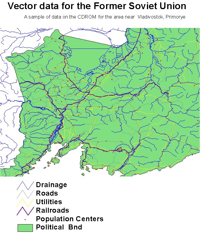
RLC Selected Infrastructure Data for the Former Soviet Union, 1993
National Aeronautics and Space Administration —
This data set consists of roads, drainage, railroads, utilities, and population center information in readily usable vector format for the land area of the Former... -
Federal
SHIFT: Wetland Spectra, Salinity, and Fractional Cover, Devereux Slough, CA, 2022
National Aeronautics and Space Administration —
This dataset includes field data, analysis code, and corresponding airborne imagery collected and generated during the 2022 NASA Surface Biology Geology (SBG) High... -
Federal
Fermi GBM Burst Catalog
National Aeronautics and Space Administration —
When referencing results from this online catalog, please cite von Kienlin, A. et al. 2020,... -
Federal
Global Soil Texture and Derived Water-Holding Capacities (Webb et al.)
National Aeronautics and Space Administration —
A standardized global data set of soil horizon thicknesses and textures (particle size distributions) was compiled by Webb et al. This data set will be used for the... -
Federal
Global 1-km Gridded Thickness of Soil, Regolith, and Sedimentary Deposit Layers
National Aeronautics and Space Administration —
This data set provides high-resolution estimates of the thickness of the permeable layers above bedrock (soil, regolith, and sedimentary deposits) within a global... -
Federal
Global Hyperspectral Imaging Spectral-library of Agricultural crops for Central Asia V001
National Aeronautics and Space Administration —
The Global Hyperspectral Imaging Spectral-library of Agricultural crops (GHISA) is a comprehensive compilation, collation, harmonization, and standardization of... -
Federal
LBA-ECO CD-06 Physical, Political, and Hydrologic Maps, Ji-Parana River Basin, Brazil
National Aeronautics and Space Administration —
This data set contains physical, hydrologic, political, demographic, and societal maps for the Ji-Parana River Basin, in the state of Rondonia, Brazil. These data... -
Federal
LBA-ECO CD-08 Tree Diameter Measurements, Jacaranda Plots, Manaus, Brazil: 1999-2001
National Aeronautics and Space Administration —
This data set provides diameter at breast height (DBH) measurements made of trees in a dense terra-firme tropical moist forest at the ZF-2 Experimental Station, 90 km... -
Federal
LBA Regional Wetlands Data Set, 1-Degree (Matthews and Fung)
National Aeronautics and Space Administration —
This database, compiled by Matthews and Fung (1987), provides information on the distribution and environmental characteristics of natural wetlands. The database was... -
Federal
MMS 2 Digital Signal Processor (DSP) Double Probe (ADP, SDP), Electric Field Power Spectral Density, Level 2 (L2), Slow Mode, 16 s Data
National Aeronautics and Space Administration —
The MMS electric field power spectral density (EPSD) is computed onboard by the Digital Signal Processor (DSP). The fast Fourier transform (FFT) calculation is... -
Federal
LiDAR and DTM Data from Tapajos National Forest in Para, Brazil, 2008
National Aeronautics and Space Administration —
This data set provides LiDAR point clouds and digital terrain models (DTM) from surveys over the Tapajos National Forest in Belterra municipality, Para, Brazil during... -
Federal
BOREAS TE-18 Geosail Canopy Reflectance Model
National Aeronautics and Space Administration —
The SAIL (Scattering from Arbitrarily Inclined Leaves) model was combined with the Jasinski geometric model to simulate canopy spectral reflectance and absorption of... -
Federal
1:100,000-scale Digital Line Graphs (DLG) from the U.S. Geological Survey
National Aeronautics and Space Administration —
Digital line graph (DLG) data are digital representations of cartographic information. DLG's of map features are converted to digital form from maps and related...

Official websites use .gov
A
.gov website belongs to an official government
organization in the United States.
Secure .gov websites use HTTPS
A
lock (
) or https:// means you’ve safely connected to
the .gov website. Share sensitive information only on official,
secure websites.