
-
Federal
TERRA MODIS High Resolution Level 3 daily aerosol data, 0.1x0.1 degree grid Version 001 (AER_DBDT_D10KM_L3_MODIS_TERRA) at GES DISC
National Aeronautics and Space Administration —
This High-Resolution (0.1 x 0.1 degree) Level 3 daily Aerosol Optical Depth (AOD) product is generated by combining two Moderate Resolution Imaging Spectroradiometer... -
Federal
LBA-ECO LC-21 Selective Logging Activity in the Brazilian Amazon: 1999-2002
National Aeronautics and Space Administration —
This data set provides the results of analyses of Landsat Enhanced Thematic Mapper Plus (ETM+) images for selective logging activity in the Brazilian states of Para,... -
Federal
LUH1: Harmonized Global Land Use for Years 1500-2100, V1
National Aeronautics and Space Administration —
These data represent fractional land use and land cover patterns annually for the years 1500 - 2100 for the globe at 0.5-degree (~50-km) spatial resolution. Land use... -
Federal
Leaf Area Index Maps at 30-m Resolution, VALERI Site, Larose, Canada
National Aeronautics and Space Administration —
This data set provide local LAI maps for the Larose (Ontario) site in Canada. These derived maps may also be useful for validating other LAI maps over this same site... -
Federal
LiDAR Derived Biomass, Canopy Height, and Cover for New England Region, USA, 2015
National Aeronautics and Space Administration —
This dataset provides 30 m gridded estimates of aboveground biomass density (AGBD), forest canopy height, and tree canopy coverage for the New England Region of the... -
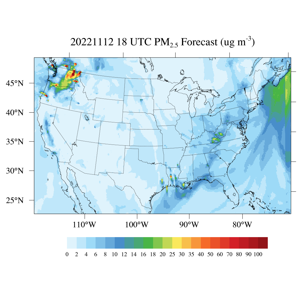
Federal
HAQES 3-Hourly Ensemble mean surface total PM2.5 concentration, North America V1 (HAQES_NA_PM25_TOT) at GES DISC
National Aeronautics and Space Administration —
This product provides HAQES 3-hourly ensemble mean surface total PM2.5 concentration over the continental United States (CONUS) and surrounding regions. The data is... -
Federal
Sentinel-5P TROPOMI Ozone Profile 1-Orbit L2 30km x 30km V2 (S5P_L2__O3__PR_HiR) at GES DISC
National Aeronautics and Space Administration —
Starting from August 6th in 2019, Sentinel-5P TROPOMI along-track high spatial resolution (~5.5km at nadir) has been implemented. S5P_L2__O3__PR_HiR data collection... -
Federal
LBA-ECO LC-01 Landsat MSS, TM, ETM+ Imagery, Northern Ecuadorian Amazon: 1973-2002
National Aeronautics and Space Administration —
This data set contains a time series of early Landsat-4 MSS satellite imagery as well as Landsat-5 TM and Landsat-7 ETM+ satellite imagery of the northern Ecuadorian... -
Federal
BOREAS TGB-04 NSA-BVP Tower Flux and Meteorological Data
National Aeronautics and Space Administration —
The BOREAS TGB-04 team measured the exchange of heat, water, and CO2 between a boreal forest beaver pond and the atmosphere in the NSA for the ice-free period of... -
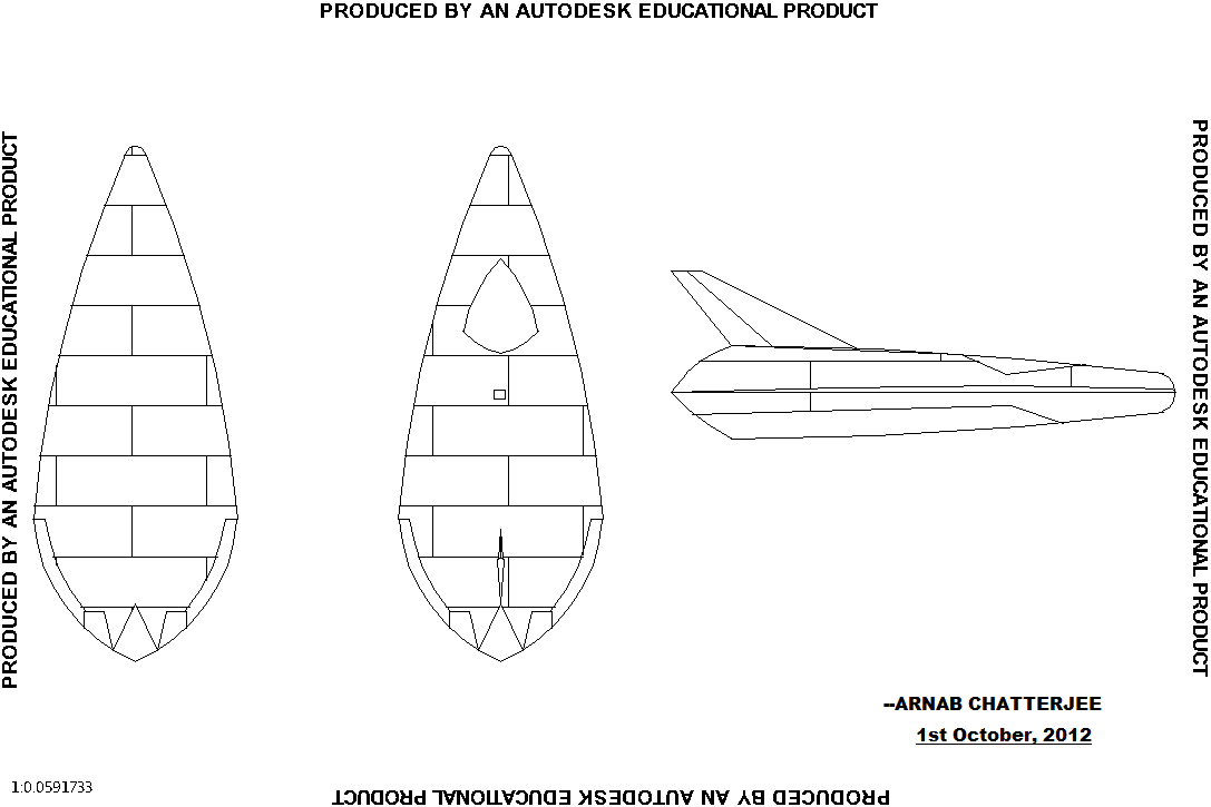
Federal
Single reusable spacecraft
National Aeronautics and Space Administration —
Design of a my single person reusable spacecraft. It can carry one person and it has to be dropped from an aircraft at an altitude of 40,000 - 45,000 feet. Can be the... -
Federal
Global Salt Marsh Change, 2000-2019
National Aeronautics and Space Administration —
This dataset provides global salt marsh change, including loss and gain for five-year periods from 2000-2019. Loss and gain at a 30 m spatial resolution were... -
Federal
Vulcan: High-Resolution Hourly Fossil Fuel CO2 Emissions in USA, 2010-2015, Version 3
National Aeronautics and Space Administration —
The Vulcan version 3.0 hourly dataset quantifies hourly emissions at a 1-km resolution for the 2010-2015 time period. Estimates are provided of hourly carbon dioxide... -
Federal
MLS/Aura Level 3 Monthly Binned Methyl Chloride (CH3Cl) Mixing Ratio on Assorted Grids V004 (ML3MBCH3CL) at GES DISC
National Aeronautics and Space Administration —
ML3MBCH3CL is the EOS Aura Microwave Limb Sounder (MLS) monthly binned on various vertical grids product for methyl chloride (CH3Cl) derived from radiances measured... -
Federal
Amazon River Basin Precipitation, 1972-1992
National Aeronautics and Space Administration —
The Amazon River Basin precipitation grids were derived from data which was collected daily by the gauging network operated by the Divisao Nacional de Aguas e Energia... -
Federal
LBA-ECO LC-04 IBIS Model Simulations for the Amazon and Tocantins Basins: 1921-1998
National Aeronautics and Space Administration —
The provided data were generated by the Integrated BIosphere Simulator (IBIS) terrestrial ecosystem model (Foley et al. 1996, Kucharik et al. 2000) using data from... -
Federal
TROPICS01 L2B Deep Multispectral INtensity (DMIN) of Tropical Cyclones Estimator Algorithm V1.0
National Aeronautics and Space Administration —
The "Time-Resolved Observations of Precipitation structure and storm Intensity with a Constellation of Smallsats" (TROPICS) mission has a goal of providing nearly... -
Federal
MLS/Aura Level 3 Monthly Binned Water Vapor (H2O) Mixing Ratio on Assorted Grids V004 (ML3MBH2O) at GES DISC
National Aeronautics and Space Administration —
ML3MBH2O is the EOS Aura Microwave Limb Sounder (MLS) monthly binned on various vertical grids product for water vapor (H2O) derived from radiances measured primarily... -
Federal
Annual Burned Area from Landsat, Mawas, Central Kalimantan, Indonesia, 1997-2015
National Aeronautics and Space Administration —
This dataset provides maps of annual burned area for the part of Mawas conservation program in Central Kalimantan, Indonesia from 1997 through 2015. Landsat imagery... -
Federal
GPM IMERG Final Precipitation L3 Half Hourly 0.1 degree x 0.1 degree V07 (GPM_3IMERGHH) at GES DISC
National Aeronautics and Space Administration —
Version 07B is the current version of the IMERG data sets. Older versions will no longer be available and have been superseded by Version 07.The Integrated Multi-...

Official websites use .gov
A
.gov website belongs to an official government
organization in the United States.
Secure .gov websites use HTTPS
A
lock (
) or https:// means you’ve safely connected to
the .gov website. Share sensitive information only on official,
secure websites.