
-
Federal
Global Population Density Grid Time Series Estimates
National Aeronautics and Space Administration —
The Global Population Density Grid Time Series Estimates provide a back-cast time series of population density grids based on the year 2000 population grid from... -
Federal
Global Vegetation Greenness (NDVI) from AVHRR GIMMS-3G+, 1981-2022
National Aeronautics and Space Administration —
This dataset holds the Global Inventory Modeling and Mapping Studies-3rd Generation V1.2 (GIMMS-3G+) data for the Normalized Difference Vegetation Index (NDVI). NDVI... -
Federal
MODIS/Terra+Aqua Photosynthetically Active Radiation Daily/3-Hour L3 Global 0.05Deg CMG V062
National Aeronautics and Space Administration —
The MCD18C2 Version 6.2 is a Moderate Resolution Imaging Spectroradiometer (MODIS) Terra and Aqua combined Photosynthetically Active Radiation (PAR) gridded Level 3... -
Federal
Shared Socioeconomic Pathways (SSPs) Literature Database, v1, 2014-2019
National Aeronautics and Space Administration —
The Shared Socioeconomic Pathways (SSPs) Literature Database, v1, 2014-2019 consists of biographic information, abstracts, and analysis of 1,360 articles published... -
Federal
SWOT Level 2 Nadir Altimeter Geophysical Data Record with Waveforms - SSHA
National Aeronautics and Space Administration —
The SWOT Level 2 Nadir Altimeter Geophysical Data Record (GDR) with Waveforms dataset produced by the Surface Water and Ocean Topography (SWOT) mission provides sea... -
Federal
Global Human Built-up And Settlement Extent (HBASE) Dataset From Landsat
National Aeronautics and Space Administration —
The Global Human Built-up And Settlement Extent (HBASE) Dataset from Landsat is a global map of HBASE derived from the Global Land Survey (GLS) Landsat dataset for... -
Federal
OCO-3 Level 1B calibrated, geolocated calibration spectra, V10 (OCO3_L1B_Calibration) at GES DISC
National Aeronautics and Space Administration —
Version 10 is the current version of the data set. Older versions will no longer be available and are superseded by Version 10. The Orbiting Carbon Observatory -3... -
Federal
Global Estimated Net Migration Grids by Decade: 1970-2000
National Aeronautics and Space Administration —
The Global Estimated Net Migration by Decade: 1970-2000 data set provides estimates of net migration over the three decades from 1970 to 2000. Because of the lack of... -
Federal
U.S. Census Grids (Summary File 3), 2000: Metropolitan Statistical Areas
National Aeronautics and Space Administration —
The U.S. Census Grids (Summary File 3), 2000: Metropolitan Statistical Areas data set contains grids of demographic and socioeconomic data from the year 2000 U.S.... -
Federal
African Climate Mobility Initiative (ACMI): Bilateral Migration Projections
National Aeronautics and Space Administration —
The African Climate Mobility Initiative (ACMI): Bilateral Migration Projections consists of projections for bilateral migration flows at 5-year intervals from 2015 to... -
Federal
Global Food Security-support Analysis Data (GFSAD) Cropland Extent 2015 Australia, New Zealand, China, Mongolia 30 m V001
National Aeronautics and Space Administration —
The NASA Making Earth System Data Records for Use in Research Environments (MEaSUREs) Global Food Security-support Analysis Data (GFSAD) data product provides... -
Federal
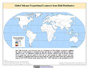
Global Volcano Proportional Economic Loss Risk Deciles
National Aeronautics and Space Administration —
Global Volcano Proportional Economic Loss Risk Deciles is a 2.5 minute grid of volcano hazard economic loss as proportions of Gross Domestic Product (GDP) per... -
Federal
Last of the Wild Project, Version 2, 2005 (LWP-2): Global Human Footprint Dataset (IGHP)
National Aeronautics and Space Administration —
The Global Human Footprint Dataset of the Last of the Wild Project, Version 2, 2005 (LWP-2) is the Human Influence Index (HII) normalized by biome. The HII is a... -
Federal
MODIS/Terra Vegetation Continuous Fields Yearly L3 Global 250m SIN Grid V061
National Aeronautics and Space Administration —
The MOD44B Version 6.1 Vegetation Continuous Fields (VCF) yearly product is a global representation of surface vegetation cover as gradations of three ground cover... -
Federal
SWOT Level 2 Radiometer Brightness Temperatures and Troposphere Operational Data Product, Version 2.0
National Aeronautics and Space Administration —
The SWOT Level 2 Radiometer Brightness Temperatures and Troposphere Operational Geophysical Data Record (OGDR) Version 1.0 dataset produced by the Surface Water and... -
Federal
VIIRS/NPP Burned Area Monthly L4 Global 500m SIN Grid V002
National Aeronautics and Space Administration —
The daily NASA/NOAA Suomi National Polar-orbiting Partnership (Suomi NPP) Visible Infrared Imaging Radiometer Suite (VIIRS) Burned Area (VNP64A1) Version 2 data... -
Federal
VIIRS/NPP Surface Reflectance 8-Day L3 Global 500m SIN Grid V002
National Aeronautics and Space Administration —
The 8-day Visible Infrared Imaging Radiometer Suite (VIIRS) Surface Reflectance (VNP09H1) Version 2 composite product provides an estimate of land surface reflectance... -
Federal
CAR ARCTAS BRDF Measurements V2 (CAR_ARCTAS_BRDF) at GES DISC
National Aeronautics and Space Administration —
ARCTAS focuses on advancing understanding of the factors driving current changes in the Arctic region including transport of mid-latitude pollution, boreal forest... -
Federal
SCATSAT-1 ESDR Level 2 Ancillary Ocean Surface Fields Version 1.1
National Aeronautics and Space Administration —
This dataset contains the first science quality release (post-provisional after v1.0) of the MEaSUREs-funded Earth Science Data Record (ESDR) of ancillary data... -
Federal
CAR SCAR-B BRDF Measurements L1 V2 (CAR_SCARB_BRDF) at GES DISC
National Aeronautics and Space Administration —
The objectives for the SCAR mission are to advance our knowledge of how the physical, chemical and radiative processes in our atmosphere are affected by sulfate...

Official websites use .gov
A
.gov website belongs to an official government
organization in the United States.
Secure .gov websites use HTTPS
A
lock (
) or https:// means you’ve safely connected to
the .gov website. Share sensitive information only on official,
secure websites.