
-
Federal
Global Roads Open Access Data Set, Version 1 (gROADSv1)
National Aeronautics and Space Administration —
The Global Roads Open Access Data Set, Version 1 (gROADSv1) was developed under the auspices of the CODATA Global Roads Data Development Task Group. The data set... -
Federal
Spatial Data from the 2011 India Census
National Aeronautics and Space Administration —
The Spatial Data from the 2011 India Census contains gridded estimates of India population at a resolution of 1 kilometer along with two spatial renderings of urban... -
Federal
AIRS/Aqua L2 Near Real Time (NRT) Cloud-Cleared Infrared Radiances (AIRS-only) V006 (AIRS2CCF_NRT) at GES DISC
National Aeronautics and Space Administration —
The Atmospheric Infrared Sounder (AIRS) Level 2 Near Real Time (NRT) Cloud-Cleared Infrared Radiances (AIRS-only) product (AIRS2CCF_NRT_006) differs from the routine... -
Federal
Archive of Census Related Products (ACRP): 1990 Census Block Statistics
National Aeronautics and Space Administration —
The 1990 Census Block Statistics portion of the Archive of Census Related Products (ACRP) contains population and housing data from the U.S. Census Bureau's 1990... -
Federal
MODIS/Aqua Surface Reflectance 8-Day L3 Global 250m SIN Grid V061
National Aeronautics and Space Administration —
The MYD09Q1 Version 6.1 product provides an estimate of the surface spectral reflectance of Aqua Moderate Resolution Imaging Spectroradiometer (MODIS) Bands 1 and 2,... -
Federal
CAR ARMCAS Arctic Cloud Radiation Measurements L1 V1 (CAR_ARMCAS_L1C) at GES DISC
National Aeronautics and Space Administration —
The Arctic Radiation Measurement in Column Atmosphere-surface System (ARMCAS) was a collaborative research effort between the Cloud and Aerosol Research (CAR) Group,... -
Federal
U.S. Census Grids (Summary File 3), 2000
National Aeronautics and Space Administration —
The U.S. Census Grids (Summary File 3), 2000 data set contains grids of demographic and socioeconomic data from the year 2000 U.S. census in ASCII and GeoTIFF... -
Federal
OCO-3 Level 2 CO2 prior based on CO2 monthly flask record, global meteorology, and age of air, Forward Processing V11 (OCO3_L2_CO2Prior) at GES DISC
National Aeronautics and Space Administration —
Version 11 is the current version of the data set. Older versions will no longer be available and are superseded by Version 11. The Orbiting Carbon Observatory -3... -
Federal
MODIS/Terra Land Surface Temperature/Emissivity 8-Day L3 Global 1km SIN Grid V061
National Aeronautics and Space Administration —
The Terra Moderate Resolution Imaging Spectroradiometer (MODIS) Land Surface Temperature/Emissivity 8-Day (MOD11A2) Version 6.1 product provides an average 8-day per-... -
Federal
Global Reservoir and Dam Database, Version 1 (GRanDv1): Reservoirs, Revision 01
National Aeronautics and Space Administration —
Global Reservoir and Dam Database, Version 1, Revision 01 (v1.01) contains 6,862 records of reservoirs and their associated dams with a cumulative storage capacity of... -
Federal
GEDI L4C Footprint Level Waveform Structural Complexity Index, Version 2
National Aeronautics and Space Administration —
This dataset contains Global Ecosystem Dynamics Investigation (GEDI) Level 4C (L4C) Version 2 predictions of the Waveform Structural Complexity Index (WSCI) and... -
Federal
Aquarius Official Release Level 3 Rain-flagged Sea Surface Salinity Standard Mapped Image Mission Cumulative Data V5.0
National Aeronautics and Space Administration —
Aquarius Level 3 sea surface salinity (SSS) standard mapped image data contains gridded 1 degree spatial resolution SSS averaged overdaily, 7 day, monthly, and... -
Federal
Jason-1 GDR version E NetCDF
National Aeronautics and Space Administration —
The Jason-1 Geophysical Data Records (GDR) contain full accuracy altimeter data to measure sea surface height, with a high precision orbit (accuracy ~1.5 cm). The... -
Federal
ABoVE: Boreal Forest Resilience Study 2020-2022, Fairbanks AK
National Aeronautics and Space Administration —
This dataset includes five metrics of forest resilience (recruitment, invasives, permafrost change, tree damage, and radial growth) at five recently burned forest... -
Federal
Archive of Census Related Products (ACRP): 1992 Boundary Files
National Aeronautics and Space Administration —
The 1992 Boundary Files portion of the Archive of Census Related Products (ACRP) consists of 1992 boundary data from the U.S. Census Bureau's Topologically Integrated... -
Federal
GRACE/GRACE-FO Level-4 Monthly Global Ocean Mass Anomaly version 01 from NASA MEaSUREs HOMaGE project
National Aeronautics and Space Administration —
This data set contains the monthly Global Ocean Mass Anomalies (goma) since 04/2002, as measured by the GRACE and GRACE Follow-On (G/GFO) satellite missions. The data... -
Federal
RSS SMAP Level 2C Sea Surface Salinity NRT V6.0 Validated Dataset
National Aeronautics and Space Administration —
The SMAP-SSS level 2C near real-time (NRT) V6.0 dataset produced by the Remote Sensing Systems (RSS) and sponsored by the NASA Ocean Salinity Science Team, is a... -
Federal
Near Real-Time MODIS/Terra L3 Global Daily 500m SIN Grid Snow Cover, Snow Albedo, and Snow Surface Properties, Version 1
National Aeronautics and Space Administration —
This data set contains the following parameters: snow fraction (on the ground), viewable snow fraction, snow cover duration, snow grain size, dust concentration, snow... -
Federal
Monthly Frequency of Dust Storm over Land for Varying Intensities, Based on MODIS Aqua Deep Blue Level 2 Aerosol Products MYD04_L2 Collection 6.1, on a Global 0.1 by 0.1 Degree Grid, Level 3 Version 1 (MYDFDS_MON_GLB_L3) at GES DISC
National Aeronautics and Space Administration —
Version 1 is the current version of the dataset.This collection MYDFDS_MON_GLB_L3 provides level 3 monthly frequency of dust storms (FDS) over land from 175°W to... -
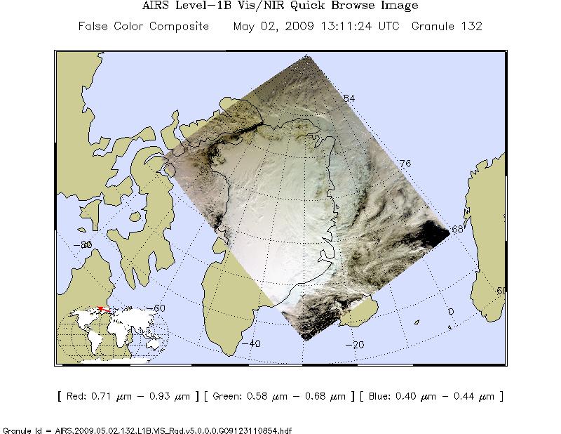
Federal
AIRS/Aqua L1B Near Real Time (NRT) Visible/Near Infrared (VIS/NIR) geolocated and calibrated radiances V005 (AIRVBRAD_NRT) at GES DISC
National Aeronautics and Space Administration —
The AIRS Visible/Near Infrared (VIS/NIR) Level 1B Near Real Time (NRT) product (AIRVBRAD_NRT_005) differs from the routine product (AIRVBRAD_005) in 2 ways to meet...

Official websites use .gov
A
.gov website belongs to an official government
organization in the United States.
Secure .gov websites use HTTPS
A
lock (
) or https:// means you’ve safely connected to
the .gov website. Share sensitive information only on official,
secure websites.