
-
Federal
RapidScat Level 2B Ocean Wind Vectors in 12.5km Slice Composites Version 1.3
National Aeronautics and Space Administration —
This dataset contains the RapidScat Level 2B 12.5km Version 1.3 science-quality ocean surface wind vectors, which are intended as a replacement and continuation of... -
Federal
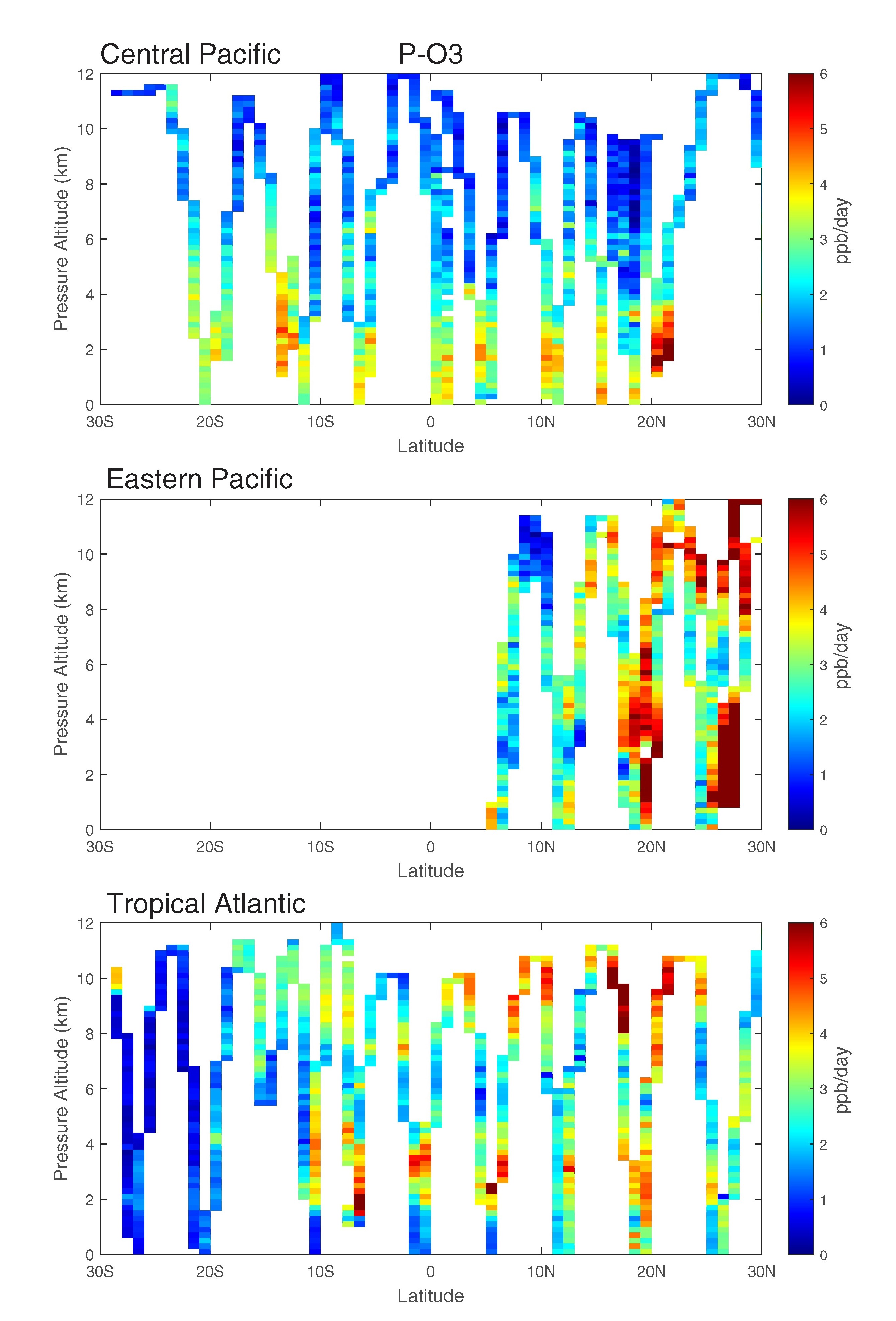
ATom: CAM-chem/CESM2 Model Outputs Along Flight Tracks, 2016-2018
National Aeronautics and Space Administration —
This dataset contains CAM-chem (Community Atmosphere Model with Chemistry) model outputs along ATom flight tracks. CAM-chem is a component of the Community Earth... -
Federal
Timeseries of Arctic-Boreal Lake Area Derived from CubeSat Imagery, 2017
National Aeronautics and Space Administration —
This dataset provides near-daily lake area timeseries for 85,358 lakes across four study areas in Northern Canada and Alaska, USA, between May 1 and October 1, 2017.... -
Federal
RapidScat Level 1B Time-Ordered Geo-Located Sigma-0 Version 2.0
National Aeronautics and Space Administration —
This dataset contains the ISS-RapidScat Version 2.0 Level 1B geo-located Sigma-0 measurements and antenna pulse "egg" and "slice" geometries as derived from ephemeris... -
Federal
Western North American FLEXPART Back Trajectory 1999 Data
National Aeronautics and Space Administration —
WNA-FLEXPART-BackTraj-1999 is the 1999 Western North America Back Trajectory data using the FLEXible PARTicle (FLEXPART) dispersion model. Data collection for this... -
Federal
Open Source And General Resource Software
National Aeronautics and Space Administration —
This dataset lists out all software in use by NASA -
Federal
Soil Organic Carbon Stock Estimates with Uncertainty across Latin America
National Aeronautics and Space Administration —
This dataset provides 5 x 5 km gridded estimates of soil organic carbon (SOC) across Latin America that were derived from existing point soil characterization data... -
Federal
NACP Site: Terrestrial Biosphere Model and Aggregated Flux Data in Standard Format
National Aeronautics and Space Administration —
This data set provides standardized output variables for gross primary productivity (GPP), net ecosystem exchange (NEE), leaf area index (LAI), ecosystem respiration... -
Federal
CSR TELLUS GRACE Level-3 Monthly Ocean Bottom Pressure Anomaly Release 6.0 version 04
National Aeronautics and Space Administration —
The monthly ocean bottom pressure anomaly grids are given as equivalent water thickness changes derived from GRACE & GRACE-FO time-variable gravity observations... -
Federal
NACP MCI: CO2 Emissions Inventory, Upper Midwest Region, USA., 2007
National Aeronautics and Space Administration —
This data set provides a bottom-up CO2 emissions inventory for the mid-continent region of the United States for the year 2007. The study was undertaken as part of... -
Federal
Western North American FLEXPART Back Trajectory 1994 Data
National Aeronautics and Space Administration —
WNA-FLEXPART-BackTraj-1994 is the 1994 Western North America Back Trajectory data using the FLEXible PARTicle (FLEXPART) dispersion model. Data collection for this... -
Federal
ATom: Data Stream for Modeling the Reactivity of ATom Air Parcels, 2016-2018
National Aeronautics and Space Administration —
This dataset provides Modeling Data Stream (MDS) and Reactivity Data Stream (RDS) products for each of the four ATom campaigns conducted from 2016 to 2018. MDS files... -
Federal
LBA-ECO CD-10 Tree DBH Measurements at the km 67 Tower Site, Tapajos National Forest
National Aeronautics and Space Administration —
This data sets reports diameter at breast height (DBH) measurements in the old-growth upland forest at the Para Western (Santarem) - km 67, Primary Forest Tower Site.... -
Federal
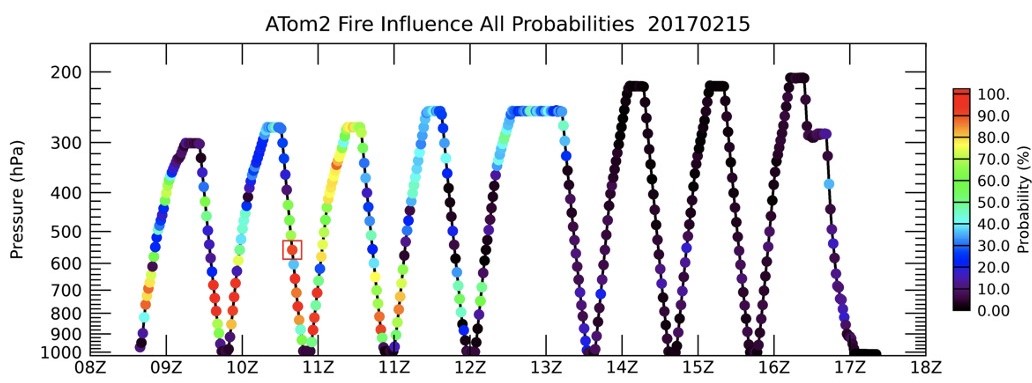
ATom: Back Trajectories and Influences of Air Parcels Along Flight Track, 2016-2018
National Aeronautics and Space Administration —
This dataset contains back trajectories, boundary layer influences, and convective influences of air parcels along NASA DC-8 aircraft's flight tracks during the four... -
Federal
SAFARI 2000 Global Burned Area Map, 1-km, Southern Africa, 2000
National Aeronautics and Space Administration —
The Global Burned Area 2000 initiative (GBA2000) was launched by the Global Vegetation Mapping Unit of the Joint Research Centre of the European Commission, in... -
Federal
LBA-ECO LC-02 Biophysical Measurements of Forests, Acre, Brazil: 1999-2002
National Aeronautics and Space Administration —
This data set provides diameter at breast height (DBH) measurements for 1,063 trees located at the Catuaba Experimental Farm, and 812 trees located in the Humaita... -
Federal
GFZ TELLUS GRACE Level-3 Monthly Land Water-Equivalent-Thickness Surface Mass Anomaly Release 6.0 version 04
National Aeronautics and Space Administration —
The monthly land mass grids contain water mass anomalies given as equivalent water thickness derived from GRACE & GRACE-FO time-variable gravity observations...

Official websites use .gov
A
.gov website belongs to an official government
organization in the United States.
Secure .gov websites use HTTPS
A
lock (
) or https:// means you’ve safely connected to
the .gov website. Share sensitive information only on official,
secure websites.