
-
Federal
Geometry, Grid and Boundary Condition Data for EEE Combustor and Turbine
National Aeronautics and Space Administration —
The Energy Efficient Engine (EEE) program was funded by NASA in the mid-1970s to develop a more efficient turbofan engine for aircraft. The contractor reports and... -
Federal
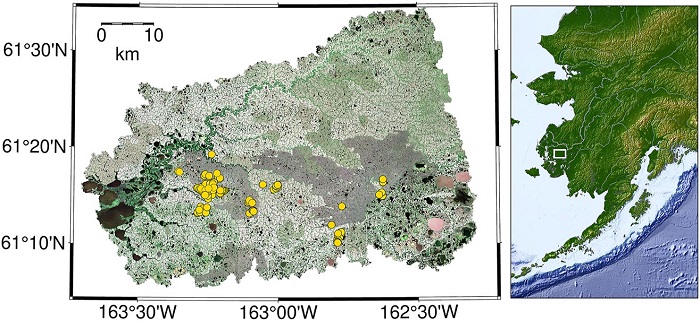
Delta-X: AVIRIS-NG L3 Derived Herbaceous Aboveground Biomass, MRD, Louisiana, USA, V3
National Aeronautics and Space Administration —
This dataset includes high-resolution (~5 m) gridded estimates of aboveground biomass (AGB), aboveground necromass (AGN), and aboveground net primary productivity... -
Federal
ATom: L2 In Situ Measurements from NOAA Nitrogen Oxides and Ozone (NOyO3) Instrument
National Aeronautics and Space Administration —
This dataset provides in situ concentrations of nitric oxide (NO), nitrogen dioxide (NO2), total reactive nitrogen oxides (NOy), and ozone (O3) measured by the NOAA... -
Federal
LBA-ECO ND-30 Nutrient Analysis and Gas Fluxes, Forest Chronosequences, Para, Brazil
National Aeronautics and Space Administration —
This data set provides fine litterfall mass and nutrient concentrations from samples collected at chronosequences established at Sao Francisco do Para and Capitao... -
Federal
NACP Aboveground Biomass and Carbon Baseline Data, V.2 (NBCD 2000), U.S.A., 2000
National Aeronautics and Space Administration —
The NBCD 2000 (National Biomass and Carbon Dataset for the Year 2000) data set provides a high-resolution (30 m) map of year-2000 baseline estimates of basal area-... -
Federal
Randomized Battery Usage 3: Room Temperature Variable Recharge Random Walk
National Aeronautics and Space Administration —
This dataset is part of a series of datasets, where batteries are continuously cycled with randomly generated current profiles. Reference charging and discharging... -
Federal
PnET Models: Carbon, Nitrogen, Water Dynamics in Forest Ecosystems (Vers. 4 and 5)
National Aeronautics and Space Administration —
PnET (Photosynthetic / EvapoTranspiration model) is a nested series of models of carbon, water, and nitrogen dynamics in forest ecosystems. The models can be used to... -
Federal
CO2 and CH4 Fluxes from Waterbodies, Yukon-Kuskokwim Delta, Alaska, 2016-2019
National Aeronautics and Space Administration —
This dataset provides estimates of carbon dioxide (CO2) and methane (CH4) diffusive fluxes from waterbodies, and watershed landcover data for the central-interior of... -
Federal
Stream Flow Storm Data (FIFE)
National Aeronautics and Space Administration —
The Storm Event Stream Flow Data Set were collected during storm events from five treatment areas within the Konza Prairie Long-Term Ecological Research (LTER) site... -
Federal
Aquarius Official Release Level 3 Rain-flagged Sea Surface Salinity Standard Mapped Image Ascending Seasonal Data V5.0
National Aeronautics and Space Administration —
Aquarius Level 3 sea surface salinity (SSS) rain-flagged standard mapped image data contains gridded 1 degree spatial resolution SSS averaged over daily, 7 day,... -
Federal
Reflectance Reference Targets (OTTER)
National Aeronautics and Space Administration —
Spectral reflectance measurements of flat field targets as reference points representative of psuedo-invariant targets as measured by the Spectron SE590... -
Federal
BOREAS TF-01 SSA-OA Understory Flux, Meteorological, and Soil Temperature Data
National Aeronautics and Space Administration —
The BOREAS TF-01 team collected energy, carbon dioxide, and momentum flux data under the canopy along with meteorological and soils data at the BOREAS SSA-OA site... -
Federal
BOREAS TE-18 Landsat TM Maximum Likelihood Classification Image of the SSA
National Aeronautics and Space Administration —
A Landsat-5 TM image from 06-Aug-1990 was used to derive this classification. The objective of this classification is to provide the BOREAS investigators with a data... -
Federal
BOREAS TE-18 Landsat TM Physical Classification Image of the SSA
National Aeronautics and Space Administration —
The objective of this classification is to provide the BOREAS investigators with a data product that characterizes the land cover of the SSA. A Landsat-5 TM image... -
Federal
NPP Tropical Forest: Cinnamon Bay, U.S. Virgin Islands, 1982-1993, R1
National Aeronautics and Space Administration —
This data set contains three ASCII files (.txt format). One data file contains above-ground biomass, litter, litterfall, herbivory, biomass change, and above-ground... -
Federal
NPP Multi-Biome: Gridded Estimates for Selected Regions Worldwide, 1954-1998, R3
National Aeronautics and Space Administration —
This data set provides two data files (.csv format) containing gridded (0.5-degree) estimates of net primary productivity (NPP), elevation, temperature,... -
Federal
NPP Tropical Forest: Luquillo, Puerto Rico, 1946-1994, R1
National Aeronautics and Space Administration —
This data set contains ten ASCII files (.txt format), one NPP file for each of the nine different montane tropical rainforest sites within the Luquillo Experimental...

Official websites use .gov
A
.gov website belongs to an official government
organization in the United States.
Secure .gov websites use HTTPS
A
lock (
) or https:// means you’ve safely connected to
the .gov website. Share sensitive information only on official,
secure websites.