

15 datasets found for "33q텔레thinkDBlII스웨디시DBl"
-
Federal
CYGNSS Level 3 MRG Science Data Record Version 3.2
National Aeronautics and Space Administration —
This dataset contains the version 3.2 CYGNSS level 3 science data record merged storm (MRG) wind speed which combines CYGNSS storm-centric gridded (SCG) wind speeds,... -
Federal
UC Berkeley CYGNSS Level 3 Daily RWAWC Watermask Version 3.2
National Aeronautics and Space Administration —
The CYGNSS Level 3 UC Berkeley Watermask Record Version 3.2 was developed by CYGNSS investigators in the Department of Civil and Environmental Engineering at the... -
Federal
SIRS/Nimbus-3 Level 1 Radiance Data V001 (SIRSN3L1) at GES DISC
National Aeronautics and Space Administration —
SIRSN3L1 is the Nimbus-3 Satellite Infrared Spectrometer (SIRS) Level 1 Radiance Data product. SIRS measured infrared radiation (11 to 36 micrometers) emitted from... -
Federal
SARP 2018 Data
National Aeronautics and Space Administration —
SARP_2018_Data is the data collected onboard the NASA DC-8 aircraft during the 2018 deployment of the Student Airborne Research Program (SARP) mission. Data... -
Federal
VISSR/GOES-1 Infrared Imagery on 70mm Film V001 (VISSRGOES1IMIR) at GES DISC
National Aeronautics and Space Administration —
VISSRGOES1IMIR is the Visible Infrared Spin-Scan Radiometer (VISSR) Infrared Imagery on 70mm Film data product from the first Geostationary Operational Environmental... -
Federal
CYGNSS Level 2 Science Data Record Version 3.0
National Aeronautics and Space Administration —
This dataset contains the Version 3.0 CYGNSS Level 2 Science Data Record which provides the time-tagged and geolocated average wind speed (m/s) and mean square slope... -
Federal
SARP 2016 Data
National Aeronautics and Space Administration —
SARP_2016_Data is the data collected onboard the NASA DC-8 aircraft during the 2016 deployment of the Student Airborne Research Program (SARP) mission. Data... -
Federal
SARP 2012 Data
National Aeronautics and Space Administration —
SARP_2012_Data is the data collected onboard the NASA P-3B aircraft during the 2012 deployment of the Student Airborne Research Program (SARP) mission. Data... -
Federal
DXC'10 Results
National Aeronautics and Space Administration —
Results for the DXC'10 Industrial Track. -
Federal
SARP 2011 Data
National Aeronautics and Space Administration —
SARP_2011_Data is the data collected onboard the NASA DC-8 aircraft during the 2011 deployment of the Student Airborne Research Program (SARP) mission. Data... -
Federal
UC Berkeley CYGNSS Level 3 Monthly RWAWC Watermask Version 3.1
National Aeronautics and Space Administration —
The CYGNSS Level 3 UC Berkeley Watermask Record Version 3.1 was developed by CYGNSS investigators in the Department of Civil and Environmental Engineering at the... -
Federal
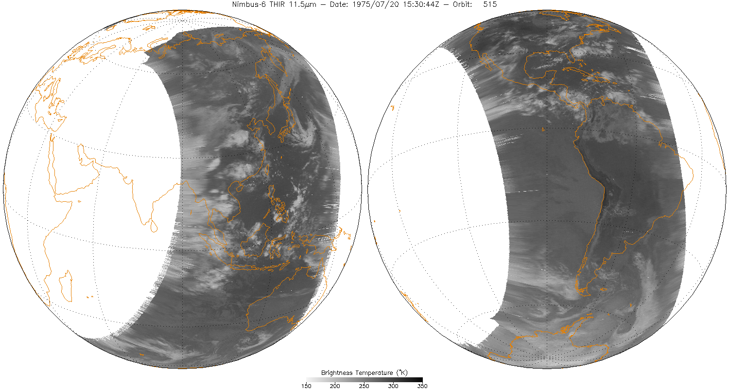
THIR/Nimbus-6 Level 1 Meteorological Radiation Data at 11.5 microns V001 (THIRN6L1CH115) at GES DISC
National Aeronautics and Space Administration —
THIRN6L1CH115 is the Nimbus-6 Temperature-Humidity Infrared Radiometer (THIR) Level 1 Meteorological Radiation Data at 11.5 microns product and contains radiances... -
Federal
SARP 2017 Data
National Aeronautics and Space Administration —
SARP_2017_Data is the data collected onboard the Wallops C-23 aircraft during the 2017 deployment of the Student Airborne Research Program (SARP) mission. Data... -
Federal
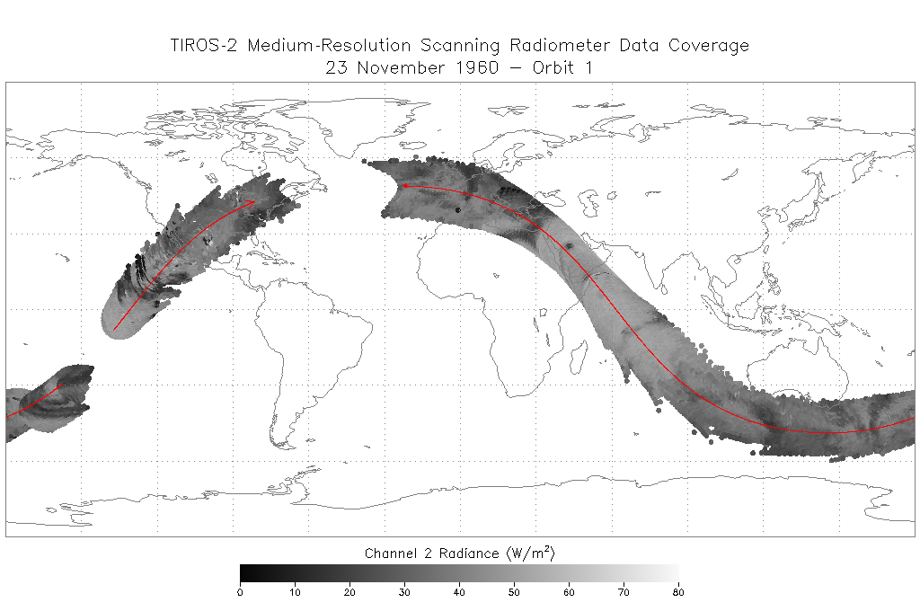
TIROS-2 Medium-Resolution Scanning Radiometer Level 1 Final Meteorological Radiation Data V001 (TIROS2L1FMRT) at GES DISC
National Aeronautics and Space Administration —
TIROS-2 Medium-Resolution Scanning Radiometer Level 1 Final Meteorological Radiation Data (FMRT) product contains radiances expressed in five infrared/visible... -
Federal
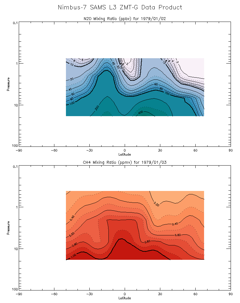
SAMS/Nimbus-7 Level 3 Zonal Means Composition Data V001 (SAMSN7L3ZMTG) at GES DISC
National Aeronautics and Space Administration —
SAMSN7L3ZMTG is the Nimbus-7 Stratospheric and Mesospheric Sounder (SAMS) Level 3 Zonal Means Composition Data Product. The Earth's surface is divided into 2.5-deg...
15 datasets found for "33q텔레thinkDBlII스웨디시DBl"