
-
Federal
Lunar Laser Ranging (LLR) data from NASA CDDIS
National Aeronautics and Space Administration —
Lunar Laser Ranging (LLR) measures the distance between the Earth and the Moon using laser ranging. A short pulse of coherent light generated by a laser (Light... -
Federal
Sentinel-1C Single Polarization Full Resolution Ground Range Detected Product Metadata
National Aeronautics and Space Administration —
The Sentinel-1C satellite was launched December 5, 2024. Sentinel-1C is the the latest satellite to be added to the Sentinel-1 constellation. The Sentinel-1... -
Federal
MODIS/Aqua Aerosol 5-Min L2 Swath Subset 10km along MLS V002 (MAM04S0) at GES DISC
National Aeronautics and Space Administration —
This is the MODIS/Aqua subset along MLS field of view track. The goal of the subset is to select and return MODIS data that are within +-100 km across the MLS track.... -
Federal
STS-68_BROWSE_SLC
National Aeronautics and Space Administration —
Browse for STS-68 SIR-C Slant Range Product -
Federal
Ground-Based Global Navigation Satellite System Data (30-second sampling, 24 hour files) from NASA CDDIS
National Aeronautics and Space Administration —
GNSS provide autonomous geo-spatial positioning with global coverage. GNSS data sets from ground receivers at the CDDIS consist primarily of the data from the U.S.... -
Federal
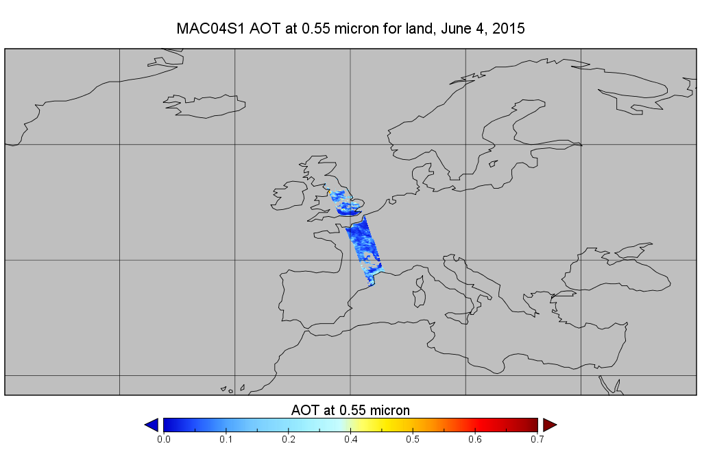
MODIS/Aqua Aerosol 10km 5-Min L2 Wide Swath Subset along CloudSat V002 (MAC04S1) at GES DISC
National Aeronautics and Space Administration —
This is the wide-swath MODIS/Aqua subset along CloudSat field of view track. The goal of the wide-swath subset is to select and return MODIS data that are within... -
Federal
TOVS GLA 5 DAY GRIDS from NOAA-12 V01 (TOVSA5ND) at GES DISC
National Aeronautics and Space Administration —
This dataset (TOVSA5ND) contains the TIROS Operational Vertical Sounder (TOVS) level 3 geophysical parameters derived using data from NOAA-12 and the physical... -
Federal
Jaeger Monthly Mean Global Precipitation Climatology 2.5 x 5.0 degree V1 (RAIN_JEAGER) at GES DISC
National Aeronautics and Space Administration —
The Jaeger Surface Rain Gauge Observations data set consists of gridded mean monthly global precipitation values for 1931 to 1960 over the continents and 1955 to 1965... -
Federal
Sentinel-1 Interferograms
National Aeronautics and Space Administration —
Sentinel-1 SLC interferometric products generated by JPL using ISCE v2.0.0, delivered by ASF -
Federal
Nimbus-7 Narrow Field of View (NFOV) Maximum Likelihood Cloud Estimation (MLCE) Data in Native Format
National Aeronautics and Space Administration —
NIMBUS7_NFOV_MLCE data are Nimbus 7 Narrow Field of View (NFOV) Maximum Likelihood Cloud Estimation (MLCE) Data in Native Format.The NIMBUS7_NFOV_MLCE data set uses... -
Federal
NOAA-20 VIIRS Level-3 Global Mapped 11µm Nighttime Sea Surface Temperature (NSST) Data, version R2024.0
National Aeronautics and Space Administration —
The Visible and Infrared Imager/Radiometer Suite (VIIRS) is a multi-disciplinary instrument that is being flown on the Joint Polar Satellite System (JPSS) series of... -
Federal
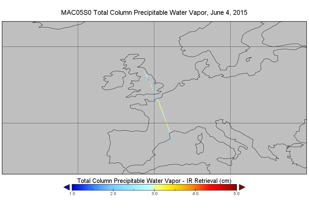
MODIS/Aqua Total Precip Water Vapor 1km and 5km 5-Min L2 Narrow Swath Subset along CloudSat V002 (MAC05S0) at GES DISC
National Aeronautics and Space Administration —
This is the narrow-swath MODIS/Aqua subset along CloudSat field of view track. The goal of the narrow-swath subset is to select and return MODIS data that are within... -
Federal
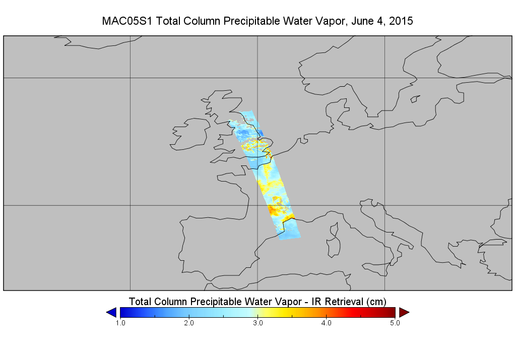
MODIS/Aqua Total Precip Water Vapor 1km and 5km 5-Min L2 Wide Swath Subset along CloudSat V002 (MAC05S1) at GES DISC
National Aeronautics and Space Administration —
This is the wide-swath MODIS/Aqua subset along CloudSat field of view track. The goal of the wide-swath subset is to select and return MODIS data that are within... -
Federal
MODIS/Aqua Geolocation Fields 1km 5-Min 1A Narrow Swath Subset along CloudSat V002 (MAC03S0) at GES DISC
National Aeronautics and Space Administration —
This is the narrow-swath MODIS/Aqua subset along CloudSat field of view track. The goal of the narrow-swath subset is to select and return MODIS data that are within... -
Federal
STS-59_METADATA_GRD
National Aeronautics and Space Administration —
Metadata for STS-59 SIR-C Ground Range Product -
Federal
TRMM Attitude and VIRS Packets and Header Record L1A V7 (TRMM_1A01) at GES DISC
National Aeronautics and Space Administration —
The Level-1A Product file, "1A01", is a concatenation of Header record, Spacecraft Attitude packets, VIRS Housekeeping Data packets, VIRS Science Data packets, QACs,... -
Federal
TOVS GLA 5 DAY GRIDS from NOAA-9 V01 (TOVSA5NF) at GES DISC
National Aeronautics and Space Administration —
This dataset (TOVSA5NF) contains the TIROS Operational Vertical Sounder (TOVS) level 3 geophysical parameters derived using data from NOAA-9 and the physical... -
Federal
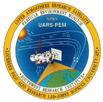
UARS PEM Level 2 VMAG AC V001 (UARPE2VMAGAC) at GES DISC
National Aeronautics and Space Administration —
The Particle Environment Monitor (PEM) level 2 Vector Magnetometer (VMAG) AC daily product contains the Vector Magnetic Field AC component. PEM was flown on the UARS...

Official websites use .gov
A
.gov website belongs to an official government
organization in the United States.
Secure .gov websites use HTTPS
A
lock (
) or https:// means you’ve safely connected to
the .gov website. Share sensitive information only on official,
secure websites.