
-
Federal
India Village-Level Geospatial Socio-Economic Data Set: 1991, 2001
National Aeronautics and Space Administration —
The India Village-Level Geospatial Socio-Economic Data Set: 1991, 2001 is a compilation of the finest level of administrative boundaries in India (village/town-level)... -
Federal
Global Population Density Grid Time Series Estimates
National Aeronautics and Space Administration —
The Global Population Density Grid Time Series Estimates provide a back-cast time series of population density grids based on the year 2000 population grid from... -
Federal
Global Human Settlement Layer: Population and Built-Up Estimates, and Degree of Urbanization Settlement Model Grid
National Aeronautics and Space Administration —
The Global Human Settlement Layer: Population and Built-Up Estimates, and Degree of Urbanization Settlement Model Grid data set provides gridded data on human... -
Federal
2014 Environmental Performance Index (EPI)
National Aeronautics and Space Administration —
The 2014 Environmental Performance Index (EPI) ranks 178 countries on 20 performance indicators in the following 9 policy categories: health impacts, air quality,... -
Federal
Georeferenced U.S. County-Level Population Projections, Total and by Sex, Race and Age, Based on the SSPs, 2020-2100
National Aeronautics and Space Administration —
The Georeferenced U.S. County-Level Population Projections, Total and by Sex, Race and Age, Based on the SSPs, 2020-2100 consists of county-level population... -
Federal
Global Rural-Urban Mapping Project, Version 1 (GRUMPv1): Urban Extents Grid
National Aeronautics and Space Administration —
The Global Rural-Urban Mapping Project, Version 1 (GRUMPv1): Urban Extents Grid distinguishes urban and rural areas based on a combination of population counts... -
Federal
Global Cyclone Mortality Risks and Distribution
National Aeronautics and Space Administration —
The Global Cyclone Mortality Risks and Distribution is a 2.5 minute grid of global cyclone mortality risks. Gridded Population of the World, Version 3 (GPWv3) data... -
Federal
Global Mangrove Forests Distribution, 2000
National Aeronautics and Space Administration —
The Global Mangrove Forests Distribution, 2000 data set is a compilation of the extent of mangroves forests from the Global Land Survey and the Landsat archive with... -
Federal
West Africa Coastal Vulnerability Mapping: Demographic and Health Survey Data Sets
National Aeronautics and Space Administration —
The West Africa Coastal Vulnerability Mapping: Demographic and Health Survey Data Sets present grids of maternal education levels and household wealth based on... -
Federal
Global Rural-Urban Mapping Project, Version 1 (GRUMPv1): Urban Extent Polygons, Revision 02
National Aeronautics and Space Administration —
The Global Rural-Urban Mapping Project, Version 1 (GRUMPv1): Urban Extent Polygons, Revision 02 is an update to Revision 01, which included new settlements and... -
Federal
MLS/Aura Near-Real-Time L2 Water Vapor (H2O) Mixing Ratio V005 (ML2H2O_NRT) at GES DISC
National Aeronautics and Space Administration —
ML2H2O_NRT is the EOS Aura Microwave Limb Sounder (MLS) Near-Real-Time (NRT) product for water vapor (H2O). This product contains H2O profiles derived from the 190... -
Federal
Daily and Annual PM2.5 Concentrations for the Contiguous United States, 1-km Grids, v1 (2000 - 2016)
National Aeronautics and Space Administration —
The Daily and Annual PM2.5 Concentrations for the Contiguous United States, 1-km Grids, v1 (2000 - 2016) data set includes predictions of PM2.5 concentrations in grid... -
Federal
2018 Environmental Performance Index (EPI)
National Aeronautics and Space Administration —
The 2018 Environmental Performance Index (EPI) ranks 180 countries on 24 performance indicators in the following 10 issue categories: air quality, water and... -
Federal
JPL TELLUS GRACE Level-3 Monthly Land Water-Equivalent-Thickness Surface Mass Anomaly Release 6.0 version 04 in netCDF/ASCII/GeoTIFF Formats
National Aeronautics and Space Administration —
The monthly land mass grids contain water mass anomalies given as equivalent water thickness derived from GRACE & GRACE-FO time-variable gravity observations... -
Federal
Global Subnational Infant Mortality Rates, Version 2.01
National Aeronautics and Space Administration —
The Global Subnational Infant Mortality Rates, Version 2.01 consist of Infant Mortality Rate (IMR) estimates for 234 countries and territories, 143 of which include... -
Federal
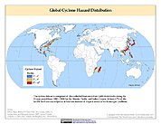
Global Cyclone Hazard Frequency and Distribution
National Aeronautics and Space Administration —
The Global Cyclone Hazard Frequency and Distribution is a 2.5 minute grid based on more than 1,600 storm tracks for the period 1 January 1980 through 31 December 2000...

Official websites use .gov
A
.gov website belongs to an official government
organization in the United States.
Secure .gov websites use HTTPS
A
lock (
) or https:// means you’ve safely connected to
the .gov website. Share sensitive information only on official,
secure websites.