

11 datasets found for ""Natural Resources""
-
Federal
NPP Multi-Biome: Gridded Estimates for Selected Regions Worldwide, 1954-1998, R3
National Aeronautics and Space Administration —
This data set provides two data files (.csv format) containing gridded (0.5-degree) estimates of net primary productivity (NPP), elevation, temperature,... -
Federal
NARSTO Texas Particulate Matter (PM) 2.5 Sampling and Analysis Study: 1997-1998 Data
National Aeronautics and Space Administration —
NARSTO_Texas_PM2.5_Sampling_and_Analysis_Study_1997-1998_ is the North American Research Strategy for Tropospheric Ozone (NARSTO) Texas Particulate Matter (PM) 2.5... -
Federal
Russian River Ice Thickness and Duration, 1917 - 1992, Version 1
National Aeronautics and Space Administration —
This data set consists of river ice thickness measurements, and beginning and ending dates for river freeze-up events from fifty stations in northern Russia. The data... -
Federal
NARSTO EPA Supersite (SS) Houston, Texas Air Quality Study 2000 (TexAQS2000) Texas Natural Resource Conservation Commission (TNRCC) continuous ambient monitoring stations (CAMS) Air Quality Data
National Aeronautics and Space Administration —
NARSTO_EPA_HOUSTON_TEXAQS2000_CAMS_DATA is the North American Research Strategy for Tropospheric Ozone (NARSTO) Environmental Protection Agency (EPA) Supersite (SS)... -
Federal
Water Quality (WQ) monitoring program for Clear Lake, CA
National Aeronautics and Space Administration —
Clear Lake is a large, shallow, hypereutrophic lake in Northern California, USA. Clear Lake is an important water resource for the surrounding community offering many... -
Federal
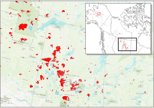
ABoVE: Wildfire Date of Burning within Fire Scars across Alaska and Canada, 2001-2019
National Aeronautics and Space Administration —
This dataset provides estimates of wildfire progression represented by date of burning (DoB) within fire scars across Alaska and Canada for the period 2001-2019. Burn... -
Federal
LMOS Wisconsin Department of Natural Resources (WDNR) Routine Ground Site Data
National Aeronautics and Space Administration —
LMOS_Ground_WDNRRoutine_Data_1 is the Lake Michigan Ozone Study (LMOS) ground site data collected at the Wisconsin Department of Natural Resources (WDNR) Routine... -
Federal
Global Soil Profile Data (ISRIC-WISE)
National Aeronautics and Space Administration —
The International Soil Reference and Information Centre-World Inventory of Soil Emission Potentials (ISRIC-WISE) international soil profile data set consists of a... -
Federal
ABoVE: Landsat-derived Burn Scar dNBR across Alaska and Canada, 1985-2015
National Aeronautics and Space Administration —
This dataset contains differenced Normalized Burned Ratio (dNBR) at 30-m resolution calculated for burn scars from fires that occurred within the Arctic Boreal and... -
Federal
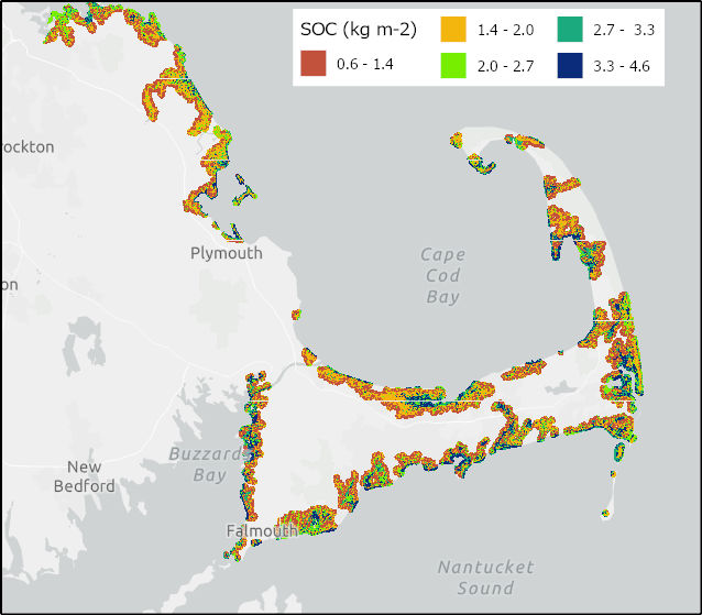
Soil Organic Carbon Distributions in Tidal Wetlands of the Northeastern USA
National Aeronautics and Space Administration —
This dataset provides estimates of soil organic carbon (SOC) in tidal wetlands for the northeastern United States. The data cover the period 1998-2018. Northeastern...
11 datasets found for ""Natural Resources""