
-
Federal
Global Landslide Catalog Export
National Aeronautics and Space Administration —
The Global Landslide Catalog (GLC) was developed with the goal of identifying rainfall-triggered landslide events around the world, regardless of size, impacts or... -
Federal
Fireball And Bolide Reports
National Aeronautics and Space Administration —
Fireballs and bolides are astronomical terms for exceptionally bright meteors that are spectacular enough to to be seen over a very wide area. The following table... -
Federal
NASA Disasters Mapping Portal
National Aeronautics and Space Administration —
This entry does not contain data itself, it is for the website, the NASA Disasters Mapping Portal: https://maps.disasters.nasa.gov The Disasters Mapping Portal... -
Federal
ATom: Dominant Role of Mineral Dust in Cirrus Cloud Formation
National Aeronautics and Space Administration —
This dataset provides: (1) In situ dust aerosol concentration measurements over remote tropical Pacific and Atlantic Oceans by NOAA Particle Analysis by Laser Mass... -
Federal
RapidScat Level 2B Ocean Wind Vectors in 12.5km Slice Composites Version 1.1
National Aeronautics and Space Administration —
This dataset contains the RapidScat Level 2B 12.5km Version 1.1 science-quality ocean surface wind vectors. The Level 2B wind vectors are binned on a 12.5 km Wind... -
Federal
Global Landslide Catalog Export
National Aeronautics and Space Administration —
The Global Landslide Catalog (GLC) was developed with the goal of identifying rainfall-triggered landslide events around the world, regardless of size, impacts or... -
Federal
Andersen et al 2020 SWJ Fig 1 data
National Aeronautics and Space Administration —
These data were used to create Fig. 1 of “Monte Carlo Evaluation of the Europa Clipper TID Margin based on the Variability of the Jovian Radiation Environment with... -
Federal
SAFARI 2000 Daily Rainfall Estimates, 0.1-Deg, Southern Africa, 1993-2001
National Aeronautics and Space Administration —
The Microwave InfraRed Algorithm (MIRA) is used to produce an imagery data set of daily mean rain rates at 0.1 degree spatial resolution over southern Africa for the... -
Federal
RapidScat Level 2B Climate Ocean Wind Vectors in 12.5km Footprints Version 2.0
National Aeronautics and Space Administration —
This dataset contains the RapidScat Level 2B 12.5km Version 2.0 Climate quality ocean surface wind vectors. The Level 2B wind vectors are binned on a 12.5 km Wind... -
Federal
NACP North American Forest Dynamics Project: Forest Disturbance and Regrowth Data
National Aeronautics and Space Administration —
This data set provides the results of time-series analyses of Landsat imagery for 55 selected forested sites across the conterminous U.S.A. The output is a pair of... -
Federal
JPL TELLUS GRACE Level-3 Monthly Land Water-Equivalent-Thickness Surface Mass Anomaly Release 6.0 version 04 in netCDF/ASCII/GeoTIFF Formats
National Aeronautics and Space Administration —
The monthly land mass grids contain water mass anomalies given as equivalent water thickness derived from GRACE & GRACE-FO time-variable gravity observations... -
Federal
NACP Site: Terrestrial Biosphere Model Output Data in Original Format
National Aeronautics and Space Administration —
This data set contains the original model output data submissions from the 24 terrestrial biosphere models (TBM) that participated in the North American Carbon... -
Federal
NACP Site: Tower Meteorology, Flux Observations with Uncertainty, and Ancillary Data
National Aeronautics and Space Administration —
This data set contains meteorological, carbon cycle flux, phenology, and ancillary data measured at 47 eddy covariance flux tower sites across North America. The data... -
Federal
RapidScat Level 2B Ocean Wind Vectors in 12.5km Slice Composites Version 1.3
National Aeronautics and Space Administration —
This dataset contains the RapidScat Level 2B 12.5km Version 1.3 science-quality ocean surface wind vectors, which are intended as a replacement and continuation of... -
Federal
RapidScat Level 2B Climate Ocean Wind Vectors in 12.5km Footprints
National Aeronautics and Space Administration —
This dataset contains the RapidScat Level 2B 12.5km Version 1.0 Climate quality ocean surface wind vectors. The Level 2B wind vectors are binned on a 12.5 km Wind... -
Federal
ABoVE: Wetland Type, Slave River and Peace-Athabasca Deltas, Canada, 2007 and 2017
National Aeronautics and Space Administration —
This dataset provides ecosystem-types for the Slave River Delta (SRD) and Peace-Athabasca Delta (PAD), Canada, for the time periods circa 2007 and circa 2017. The... -
Federal
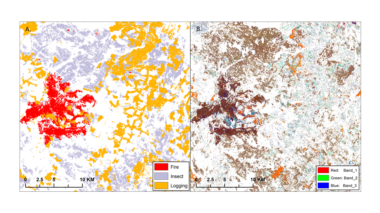
ABoVE: Landsat-derived Annual Disturbance Agents Across ABoVE Core Domain, 1987-2012
National Aeronautics and Space Administration —
This dataset provides spatial data on disturbance agents of fire, insects, and logging in the Arctic Boreal Vulnerability Experiment (ABoVE) core domain at an annual... -
Federal
JPL TELLUS GRACE Level-3 Monthly Ocean Bottom Pressure Anomaly Release 6.0 version 04
National Aeronautics and Space Administration —
The monthly ocean bottom pressure anomaly grids are given as equivalent water thickness changes derived from GRACE & GRACE-FO time-variable gravity observations... -
Federal
RapidScat Level 1B Time-Ordered Geo-Located Sigma-0 Version 2.0
National Aeronautics and Space Administration —
This dataset contains the ISS-RapidScat Version 2.0 Level 1B geo-located Sigma-0 measurements and antenna pulse "egg" and "slice" geometries as derived from ephemeris... -
Federal
JPL TELLUS GRACE Level-3 Monthly Land Water-Equivalent-Thickness Surface Mass Anomaly Release 6.0 version 04
National Aeronautics and Space Administration —
The monthly land mass grids contain water mass anomalies given as equivalent water thickness derived from GRACE & GRACE-FO time-variable gravity observations...

Official websites use .gov
A
.gov website belongs to an official government
organization in the United States.
Secure .gov websites use HTTPS
A
lock (
) or https:// means you’ve safely connected to
the .gov website. Share sensitive information only on official,
secure websites.