
-
Federal
UAVSAR_INSAR_DEM
National Aeronautics and Space Administration —
UAVSAR Repeat Pass Interferometry Scene DEM TIFF -
Federal
UAVSAR_POLSAR_METADATA
National Aeronautics and Space Administration —
UAVSAR PolSAR Scene Metadata -
Federal
UAVSAR_POLSAR_ML_COMPLEX_GRD
National Aeronautics and Space Administration —
UAVSAR PolSAR Scene Projected -
Federal
UAVSAR_POLSAR_ML_COMPLEX_SLANT
National Aeronautics and Space Administration —
UAVSAR PolSAR Scene Complex -
Federal
Water Quality (WQ) monitoring program for Clear Lake, CA
National Aeronautics and Space Administration —
Clear Lake is a large, shallow, hypereutrophic lake in Northern California, USA. Clear Lake is an important water resource for the surrounding community offering many... -
Federal
Summary Report of Community-Based Environmental and Species Observations from the Bering Sea Sub-Network, 2008-2009, Version 1
National Aeronautics and Space Administration —
The Bering Sea Sub-Network (BSSN) is comprised of a set of coastal communities representing six indigenous cultures: three in the Russian Federation and three in the... -
Federal
MACPEX WB-57 Aircraft In-situ Water Data
National Aeronautics and Space Administration —
MACPEX_Water_AircraftInSitu_WB57_Data is the in-situ water data collection during the Mid-latitude Airborne Cirrus Properties Experiment (MACPEX). Data was collected... -
Federal
Compendium of Environmental Sustainability Indicator Collections: 2006 National Footprint Accounts (NFA)
National Aeronautics and Space Administration —
The 2006 National Footprint Accounts (NFA) portion of the Compendium of Environmental Sustainability Indicator Collections, version 1.1 is a data set that measures... -
Federal
UAVSAR_POLSAR_DEM
National Aeronautics and Space Administration —
UAVSAR PolSAR Scene DEM TIFF -
Federal
UAVSAR_POLSAR_ML_COMPLEX_GRD_5X5
National Aeronautics and Space Administration —
UAVSAR PolSAR Scene Projected Multilook 5x5 -
Federal
UAVSAR_POLSAR_INCIDENCE
National Aeronautics and Space Administration —
UAVSAR PolSAR Scene Incidence Angle -
Federal
UAVSAR_INSAR_AMPLITUDE_GRD
National Aeronautics and Space Administration —
UAVSAR Repeat Pass Interferometry Ground Projected Amplitude Scene -
Federal
UAVSAR_INSAR_METADATA
National Aeronautics and Space Administration —
UAVSAR Repeat Pass Interferometry Scene Metadata -
Federal
Comparative Transcriptomic Analysis of Adult Medaka Tissues Sampled after Adaptation to a Space Environment
National Aeronautics and Space Administration —
To understand how humans adapt to space environments many experiments can be conducted on astronauts while they work aboard the Space Shuttle or the International... -
Federal
UAVSAR_POLSAR_ML_COMPLEX_GRD_3X3
National Aeronautics and Space Administration —
UAVSAR PolSAR Scene Projected Multilook 3x3 -
Federal
UAVSAR_INSAR_INTERFEROGRAM
National Aeronautics and Space Administration —
UAVSAR Repeat Pass Interferometry Scene -
Federal
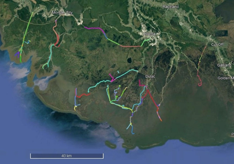
Delta-X: Sonar Bathymetry Survey of Channels, MRD, Louisiana, 2021
National Aeronautics and Space Administration —
This dataset includes bathymetry data for water channels in a portion of the Mississippi River Delta (MRD) of coastal Louisiana. The data were collected using sonar... -
Federal
Cloud Camera Data (FIFE)
National Aeronautics and Space Administration —
The FIFE Cloud Camera Data Data Set was collected to document distribution of clouds during FIFE, evaluate algorithms for identifying presence of thin cirrus, and...

Official websites use .gov
A
.gov website belongs to an official government
organization in the United States.
Secure .gov websites use HTTPS
A
lock (
) or https:// means you’ve safely connected to
the .gov website. Share sensitive information only on official,
secure websites.