
-
Federal
Global Vegetation Greenness (NDVI) from AVHRR GIMMS-3G+, 1981-2022
National Aeronautics and Space Administration —
This dataset holds the Global Inventory Modeling and Mapping Studies-3rd Generation V1.2 (GIMMS-3G+) data for the Normalized Difference Vegetation Index (NDVI). NDVI... -
Federal
NACP North American Forest Dynamics Project: Forest Disturbance and Regrowth Data
National Aeronautics and Space Administration —
This data set provides the results of time-series analyses of Landsat imagery for 55 selected forested sites across the conterminous U.S.A. The output is a pair of... -
Federal
VEMAP 2: U.S. Daily Climate Change Scenarios
National Aeronautics and Space Administration —
The Vegetation/Ecosystem Modeling and Analysis Project (VEMAP) Phase 2 has developed a number of transient climate change scenarios based on coupled atmosphere-ocean... -
Federal
NACP Integrated Wildland and Cropland 30-m Fuel Characteristics Map, U.S.A., 2010
National Aeronautics and Space Administration —
The data set provides a 30-m comprehensive fuelbed characteristics map for both the wildland and cropland areas of the conterminous United States (CONUS) for 2010.... -
Federal
Carbon Pools across CONUS using the MaxEnt Model, 2005, 2010, 2015, 2016, and 2017
National Aeronautics and Space Administration —
This dataset provides annual estimates of six carbon pools, including forest aboveground live biomass, belowground biomass, aboveground dead biomass, belowground dead... -
Federal
Tundra Plant Reflectance, CO2 Exchange, PAM Fluorometry, and Pigments, AK, 2001-2002
National Aeronautics and Space Administration —
This dataset provides measurements at tundra plots collected near Utqiagvik and Atqasuk, AK, including visible-near infrared spectral reflectance, chamber gas... -
Federal
VEMAP 2: Annual Ecosystem Model Responses to U.S. Climate Change, 1994-2100
National Aeronautics and Space Administration —
The Vegetation-Ecosystem Modeling and Analysis Project (VEMAP) was a large, collaborative, multi-institutional, international effort whose goal was to evaluate the... -
Federal
Global Organic Soil Carbon and Nitrogen (Zinke et al.)
National Aeronautics and Space Administration —
This package contains worldwide soil carbon and nitrogen data for more than 3,500 soil profiles. The database was begun about 40 years ago with the collection and... -
Federal
Northern and Mid-Latitude Soil Database, Version 1, R1
National Aeronautics and Space Administration —
The U.S. Department of Agriculture, Agriculture and Agri-Food Canada, the Russian Academy of Agricultural Sciences, the University of Copenhagen Institute of... -
Federal
Vulcan: High-Resolution Hourly Fossil Fuel CO2 Emissions in USA, 2010-2015, Version 3
National Aeronautics and Space Administration —
The Vulcan version 3.0 hourly dataset quantifies hourly emissions at a 1-km resolution for the 2010-2015 time period. Estimates are provided of hourly carbon dioxide... -
Federal
VEMAP 2: U.S. Annual Climate Change Scenarios
National Aeronautics and Space Administration —
The Vegetation/Ecosystem Modeling and Analysis Project (VEMAP) Phase 2 has developed a number of transient climate change scenarios based on coupled atmosphere-ocean... -
Federal
BOREAS TE-08 Aspen Bark Spectral Reflectance Data
National Aeronautics and Space Administration —
The BOREAS TE-08 team collected in-lab spectral reflectance data for aspen bark and leaves from three sites within the BOREAS SSA from 24-May-1994 to 16-Jun-1994 (IFC... -
Federal
Global Soil Profile Data (ISRIC-WISE)
National Aeronautics and Space Administration —
The International Soil Reference and Information Centre-World Inventory of Soil Emission Potentials (ISRIC-WISE) international soil profile data set consists of a... -
Federal
Forest Inventory and Biophysical Measurements, Brazilian Amazon, 2009-2018
National Aeronautics and Space Administration —
This dataset provides the complete catalog of forest inventory and biophysical measurements collected over selected forest research sites across the Amazon rainforest... -
Federal
NACP Aboveground Biomass and Carbon Baseline Data, V.2 (NBCD 2000), U.S.A., 2000
National Aeronautics and Space Administration —
The NBCD 2000 (National Biomass and Carbon Dataset for the Year 2000) data set provides a high-resolution (30 m) map of year-2000 baseline estimates of basal area-... -
Federal
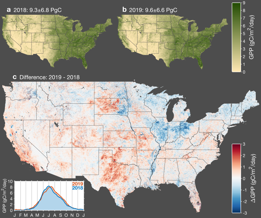
CMS: Daily Gross Primary Productivity over CONUS from TROPOMI SIF, 2018-2021
National Aeronautics and Space Administration —
This dataset includes estimates of gross primary production (GPP) for the conterminous U.S., for 2018-02-15 to 2021-10-15, based on measurements of solar-induced... -
Federal
Wind Profile Data: LIDAR - NOAA (FIFE)
National Aeronautics and Space Administration —
The aim of this wind profile study was to derive wind profiles and momentum fluxes from the National Oceanic and Atmospheric Administration (NOAA)/Wave Propagation... -
Federal
PnET Models: Carbon, Nitrogen, Water Dynamics in Forest Ecosystems (Vers. 4 and 5)
National Aeronautics and Space Administration —
PnET (Photosynthetic / EvapoTranspiration model) is a nested series of models of carbon, water, and nitrogen dynamics in forest ecosystems. The models can be used to... -
Federal
VEMAP 1: U.S. Potential Natural Vegetation
National Aeronautics and Space Administration —
The Vegetation/Ecosystem Modeling and Analysis Project (VEMAP) is an ongoing multiinstitutional, international effort addressing the response of biogeography and... -
Federal
Stream Flow Storm Data (FIFE)
National Aeronautics and Space Administration —
The Storm Event Stream Flow Data Set were collected during storm events from five treatment areas within the Konza Prairie Long-Term Ecological Research (LTER) site...

Official websites use .gov
A
.gov website belongs to an official government
organization in the United States.
Secure .gov websites use HTTPS
A
lock (
) or https:// means you’ve safely connected to
the .gov website. Share sensitive information only on official,
secure websites.