
-
Federal
Daymet: Daily Surface Weather Data on a 1-km Grid for North America, Version 4 R1
National Aeronautics and Space Administration —
This dataset provides Daymet Version 4 R1 data as gridded estimates of daily weather parameters for North America, Hawaii, and Puerto Rico. Daymet variables include... -
Federal
AVIRIS-NG L2 Surface Reflectance, Facility Instrument Collection, V1
National Aeronautics and Space Administration —
This dataset contains Level 2 (L2) orthocorrected reflectance from the Airborne Visible / Infrared Imaging Spectrometer-Next Generation (AVIRIS-NG) instrument. This... -
Federal
BigFoot Field Data for North American Sites, 1999-2003
National Aeronautics and Space Administration —
The BigFoot project gathered field data for selected EOS Land Validation Sites in North America from 1999 to 2003. Data collected and derived for varying intervals at... -
Federal
Pre-Delta-X: Total Suspended Solids of Surface Water across MRD, LA, USA, 2015-2016
National Aeronautics and Space Administration —
This dataset contains the total suspended solids (TSS) concentration of in situ water samples collected at selected sites across the Atchafalaya and Terrebonne Basins... -
Federal
LBA-ECO LC-09 Landsat TM and ETM+ Data, Sites in Rondonia and Para, Brazil: 1985-2004
National Aeronautics and Space Administration —
This data set includes 15 zipped archives of rectified .tif format Landsat 5 TM and Landsat 7 ETM+ scenes from near the study sites of Altamira, Santarem, Ponta de... -
Federal
Arctic Vegetation Plots for IBP Tundra Biome, Barrow, Alaska, 1972-2010
National Aeronautics and Space Administration —
This data set provides vegetation cover and environmental plot data collected as part of the International Biological Program (IBP), U. S. Tundra Biome Program, in... -
Federal
NACP Site: Terrestrial Biosphere Model Output Data in Original Format
National Aeronautics and Space Administration —
This data set contains the original model output data submissions from the 24 terrestrial biosphere models (TBM) that participated in the North American Carbon... -
Federal
L2 Daily Solar-Induced Fluorescence (SIF) from ERS-2 GOME, 1995-2003
National Aeronautics and Space Administration —
This dataset provides Level 2 Solar-Induced Fluorescence (SIF) of Chlorophyll estimates derived from the Global Ozone Monitoring Experiment (GOME) instrument on the... -
Federal
BOREAS TGB-08 Starch Concentration Data over the SSA-OBS and the SSA-OJP
National Aeronautics and Space Administration —
The TGB-08 team collected data to investigate the controls over non-methane hydrocarbon (NMHC) fluxes from boreal forest tree species. This data set includes... -
Federal
BOREAS RSS-08 IFC-3 ADS-PSII Measurements of BRDF at SSA-OBS and SSA-OA Sites
National Aeronautics and Space Administration —
Ground BRDF measurements were acquired by the Remote Sensing Science (RSS)-08 team to aid in the development of advanced spectral vegetation indices. The RSS-08 team... -
Federal
BOREAS TGB-04 NSA-BVP Tower Flux and Meteorological Data
National Aeronautics and Space Administration —
The BOREAS TGB-04 team measured the exchange of heat, water, and CO2 between a boreal forest beaver pond and the atmosphere in the NSA for the ice-free period of... -
Federal
LBA-ECO ND-11 Pre-harvest Forest Tree and Liana Biomass, NW Mato Grosso, Brazil: 2003
National Aeronautics and Space Administration —
The purpose of this study was to determine if spatially-explicit commercial timber inventories (CTI) could be used in conjunction with satellite imagery to improve... -
Federal
BOREAS RSS-12 Airborne Tracking Sunphotometer Measurements (C-130)
National Aeronautics and Space Administration —
The BOREAS RSS-12 team collected both ground and airborne sunphotometer measurements for use in characterizing the aerosol optical properties of the atmosphere during... -
Federal
LBA-ECO LC-01 Landsat MSS, TM, ETM+ Imagery, Northern Ecuadorian Amazon: 1973-2002
National Aeronautics and Space Administration —
This data set contains a time series of early Landsat-4 MSS satellite imagery as well as Landsat-5 TM and Landsat-7 ETM+ satellite imagery of the northern Ecuadorian... -
Federal
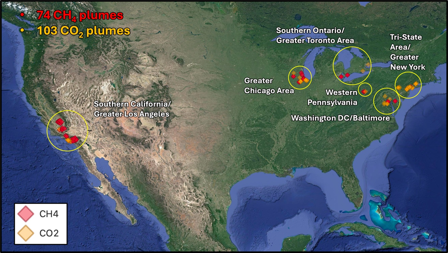
STAQS AVIRIS-NG-derived Methane and Carbon Dioxide Plumes, 2023
National Aeronautics and Space Administration —
This dataset contains enhanced column-integrated methane (CH4) and carbon dioxide (CO2) (concentration lengths) acquired from 211 flight lines across North America... -
Federal
LBA-ECO LC-04 IBIS Model Simulations for the Amazon and Tocantins Basins: 1921-1998
National Aeronautics and Space Administration —
The provided data were generated by the Integrated BIosphere Simulator (IBIS) terrestrial ecosystem model (Foley et al. 1996, Kucharik et al. 2000) using data from... -
Federal
Canopy Height and Biomass from LiDAR Surveys at La Selva, Costa Rica, 1998 and 2005
National Aeronautics and Space Administration —
This data set contains land-use, canopy height, and aboveground carbon estimates derived from LiDAR data collected at La Selva Biological Station in Costa Rica in... -
Federal
ABoVE: Ignitions, Burned Area, and Emissions of Fires in AK, YT, and NWT, 2001-2018
National Aeronautics and Space Administration —
This dataset provides estimates of daily burned area, carbon emissions, and uncertainty, and daily fire ignition locations for boreal fires in Alaska, U.S., and in... -
Federal
BOREAS TE-20 Soils Data over the NSA-MSA and Tower Sites in Raster Format
National Aeronautics and Space Administration —
This data set was gridded from vector layers of soil maps that were received from Dr. Hugo Veldhuis, who did the original mapping in the field during 1994. The vector...

Official websites use .gov
A
.gov website belongs to an official government
organization in the United States.
Secure .gov websites use HTTPS
A
lock (
) or https:// means you’ve safely connected to
the .gov website. Share sensitive information only on official,
secure websites.