
-
Federal
NACP North American Forest Dynamics Project: Forest Disturbance and Regrowth Data
National Aeronautics and Space Administration —
This data set provides the results of time-series analyses of Landsat imagery for 55 selected forested sites across the conterminous U.S.A. The output is a pair of... -
Federal
Tundra Plant Reflectance, CO2 Exchange, PAM Fluorometry, and Pigments, AK, 2001-2002
National Aeronautics and Space Administration —
This dataset provides measurements at tundra plots collected near Utqiagvik and Atqasuk, AK, including visible-near infrared spectral reflectance, chamber gas... -
Federal
LiDAR Data, DEM, and Maximum Vegetation Height Product from Southern Idaho, 2014
National Aeronautics and Space Administration —
This dataset provides the point cloud data derived from small footprint waveform LiDAR data collected in August 2014 over Reynolds Creek Experimental Watershed and... -
Federal
BioSCape: BioSoundSCape Acoustic Recordings, South Africa, 2023
National Aeronautics and Space Administration —
This dataset holds in situ sound recordings from sites in Greater Cape Floristic Region (GCFR), South Africa from June to December 2023. The recordings were collected... -
Federal
SAFARI 2000 Leaf-Level VOC Emissions, Maun, Botswana, Wet Season 2001
National Aeronautics and Space Administration —
Biogenic volatile organic compounds (VOCs) comprise a significant proportion of trace gases in the atmospheric environment and play an important role in the formation... -
Federal
GEDI-FIA Fusion: Training Lidar Models to Estimate Forest Attributes
National Aeronautics and Space Administration —
This dataset includes interpolated cumulative waveforms, with uncertainties, over national forest inventory (FIA) field plots across the contiguous United States. The... -
Federal
Global Fire Atlas with Characteristics of Individual Fires, 2003-2016
National Aeronautics and Space Administration —
The Global Fire Atlas is a global dataset that tracks the day-to-day dynamics of individual fires to determine the timing and location of ignitions, fire size,... -
Federal
Geoecology: County-Level Environmental Data for the United States, 1941-1981
National Aeronautics and Space Administration —
The Geoecology database is a compilation of environmental data for the period 1941 to 1981. The Geoecology database contains selected data on terrain and soils, water... -
Federal
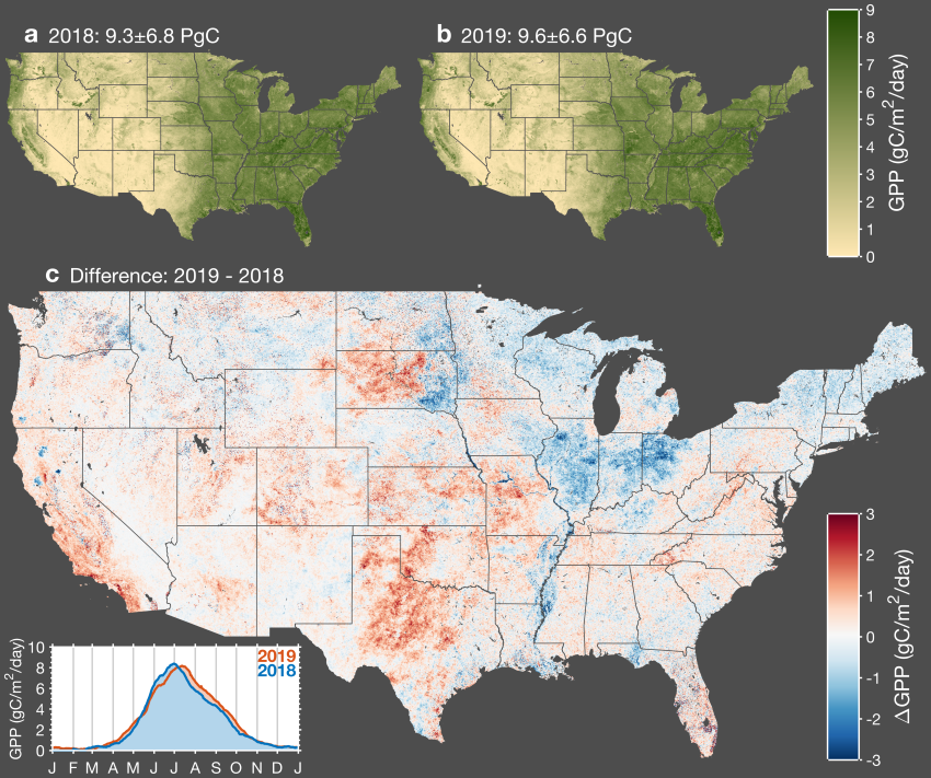
CMS: Daily Gross Primary Productivity over CONUS from TROPOMI SIF, 2018-2021
National Aeronautics and Space Administration —
This dataset includes estimates of gross primary production (GPP) for the conterminous U.S., for 2018-02-15 to 2021-10-15, based on measurements of solar-induced... -
Federal
NACP Aboveground Biomass and Carbon Baseline Data, V.2 (NBCD 2000), U.S.A., 2000
National Aeronautics and Space Administration —
The NBCD 2000 (National Biomass and Carbon Dataset for the Year 2000) data set provides a high-resolution (30 m) map of year-2000 baseline estimates of basal area-... -
Federal
Satellite Landsat TM Extr. Data (FIFE)
National Aeronautics and Space Administration —
The Thematic Mapper sensor system was used to collect the original data between February 1987 and October 1989 from which this data set was produced. Landsat TM... -
Federal
SHIFT: Laboratory Foliar Chemical Analysis Results for Field Samples, CA, 2022
National Aeronautics and Space Administration —
This dataset holds laboratory foliar chemical analyses results for field samples collected during the 2022 NASA Surface Biology Geology (SBG) High Frequency Time... -
Federal
Soil Water Prop. Derived Data (FIFE)
National Aeronautics and Space Administration —
During the 1989 FIFE field campaign, measurements were made of soil moisture release parameters and hydraulic conductivity. Bulk density and soil moisture release... -
Federal
RLC State and Regional Boundaries for the Former Soviet Union
National Aeronautics and Space Administration —
This data set of state and regional boundaries was derived from the 1:3 million scale administrative boundaries (ESRI, 1998) for the land area of the Former Soviet... -
Federal
SAFARI 2000 Aerosol Fatty Acid and Stable Isotope Data, Mongu, Dry Season 2000
National Aeronautics and Space Administration —
The Southern African Regional Science Initiative (SAFARI 2000) was conducted in part to investigate the impacts of the large-scale transport and deposition of... -
Federal
BOREAS TE-01 Soils Data over the SSA Tower Sites in Raster Format
National Aeronautics and Space Administration —
This data set was gridded from vector layers of soil maps that were received from Dr. Darwin Anderson TE-01 who did the original soil mapping in the field during... -
Federal
BOREAS HYD-01 Under Canopy Precipitation Data
National Aeronautics and Space Administration —
Under-canopy precipitation measurements were made by the BOREAS HYD-01 science team in 1994, 1995, and 1996 at various flux tower sites in the NSA and SSA. In 1994,... -
Federal
BOREAS Follow-On HMet-02 Area and Regional Hourly Gridded Met. Data, 1994-1996
National Aeronautics and Space Administration —
Phase II and III gridded data sets have been generated by an objective analysis scheme using all of the surface meteorological station data over BOREAS region for... -
Federal
BOREAS Landsat MSS Imagery: Digital Counts
National Aeronautics and Space Administration —
The Earth Resources Technology Satellite (ERTS) Program launched the first of a series of satellites (ERTS-1) in 1972. Part of the NASA Earth Resources Survey... -
Federal
BOREAS AES Five-day Averaged Surface Meteorological and Upper Air Data
National Aeronautics and Space Administration —
The Canadian Atmospheric Environment Service (AES) provided BOREAS with hourly and daily surface meteorological data from 23 of the AES meteorological stations...

Official websites use .gov
A
.gov website belongs to an official government
organization in the United States.
Secure .gov websites use HTTPS
A
lock (
) or https:// means you’ve safely connected to
the .gov website. Share sensitive information only on official,
secure websites.