
-
Federal
LBA-ECO CD-04 Soil Respiration, km 83 Tower Site, Tapajos National Forest, Brazil
National Aeronautics and Space Administration —
This data set reports on the flux of carbon dioxide from logged forest soils near the eddy flux tower at the km 83 site, Para, Brazil. The automated soil respiration... -
Federal
BOREAS TGB-04 Water and Sediment Temperature Data over the NSA-BP (Beaver Pond)
National Aeronautics and Space Administration —
The BOREAS TGB-04 team collected several data sets in support of their flux tower measurements at the NSA Beaver Pond site. This data set contains water and sediment... -
Federal
NACP North American Forest Dynamics Project: Forest Disturbance and Regrowth Data
National Aeronautics and Space Administration —
This data set provides the results of time-series analyses of Landsat imagery for 55 selected forested sites across the conterminous U.S.A. The output is a pair of... -
Federal
NACP Aboveground Biomass and Carbon Baseline Data, V.2 (NBCD 2000), U.S.A., 2000
National Aeronautics and Space Administration —
The NBCD 2000 (National Biomass and Carbon Dataset for the Year 2000) data set provides a high-resolution (30 m) map of year-2000 baseline estimates of basal area-... -
Federal
SAFARI 2000 Leaf-Level VOC Emissions, Maun, Botswana, Wet Season 2001
National Aeronautics and Space Administration —
Biogenic volatile organic compounds (VOCs) comprise a significant proportion of trace gases in the atmospheric environment and play an important role in the formation... -
Federal
Spatio-temporal Characteristics of Rainfall in Africa, 0.25 degrees, from 1998-2012
National Aeronautics and Space Administration —
This data set describes rainfall distribution statistics over the African continent, including Madagascar. The rainfall estimates are based on data from the NASA... -
Federal
Geoecology: County-Level Environmental Data for the United States, 1941-1981
National Aeronautics and Space Administration —
The Geoecology database is a compilation of environmental data for the period 1941 to 1981. The Geoecology database contains selected data on terrain and soils, water... -
Federal
Global Fire Atlas with Characteristics of Individual Fires, 2003-2016
National Aeronautics and Space Administration —
The Global Fire Atlas is a global dataset that tracks the day-to-day dynamics of individual fires to determine the timing and location of ignitions, fire size,... -
Federal
Delta-X: Bed and Suspended Sediment Grain Size, MRD, LA, USA, 2019-2021, V3
National Aeronautics and Space Administration —
This dataset includes sediment concentration and grain size distribution measurements from suspended and bed sediment samples collected in the Atchafalaya River and... -
Federal
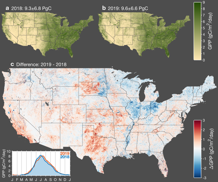
CMS: Daily Gross Primary Productivity over CONUS from TROPOMI SIF, 2018-2021
National Aeronautics and Space Administration —
This dataset includes estimates of gross primary production (GPP) for the conterminous U.S., for 2018-02-15 to 2021-10-15, based on measurements of solar-induced... -
Federal
GEDI-FIA Fusion: Training Lidar Models to Estimate Forest Attributes
National Aeronautics and Space Administration —
This dataset includes interpolated cumulative waveforms, with uncertainties, over national forest inventory (FIA) field plots across the contiguous United States. The... -
Federal
BioSCape: BioSoundSCape Acoustic Recordings, South Africa, 2023
National Aeronautics and Space Administration —
This dataset holds in situ sound recordings from sites in Greater Cape Floristic Region (GCFR), South Africa from June to December 2023. The recordings were collected... -
Federal
BOREAS TE-08 Aspen Bark Spectral Reflectance Data
National Aeronautics and Space Administration —
The BOREAS TE-08 team collected in-lab spectral reflectance data for aspen bark and leaves from three sites within the BOREAS SSA from 24-May-1994 to 16-Jun-1994 (IFC... -
Federal
Amazon Forest Structure from Airborne Lidar, ED2 Initial Condition Files, 2016
National Aeronautics and Space Administration —
This dataset provides initial condition files for initializing the Ecosystem Demography Model (ED2). This dataset holds regional forest structure characteristics... -
Federal
NACP Regional: National Greenhouse Gas Inventories and Aggregated Gridded Model Data
National Aeronautics and Space Administration —
This data set provides two products that were derived from the recently published North American Carbon Program (NACP) Regional Synthesis 1-degree terrestrial... -
Federal
ABoVE: Passive Microwave-derived Annual Snowoff Date Maps, 1988-2018
National Aeronautics and Space Administration —
This dataset provides annual maps of the snowoff (SO) date from 1988-2018 across Alaska and parts of Far East Russia and northwest Canada at a resolution of 6.25 km.... -
Federal
NACP North American 8-km Net Ecosystem Exchange and Component Fluxes, 2004
National Aeronautics and Space Administration —
This data set provides modeled carbon flux estimates at 8-km spatial resolution over North America for the year 2004 of (1) net ecosystem exchange (NEE) of carbon... -
Federal
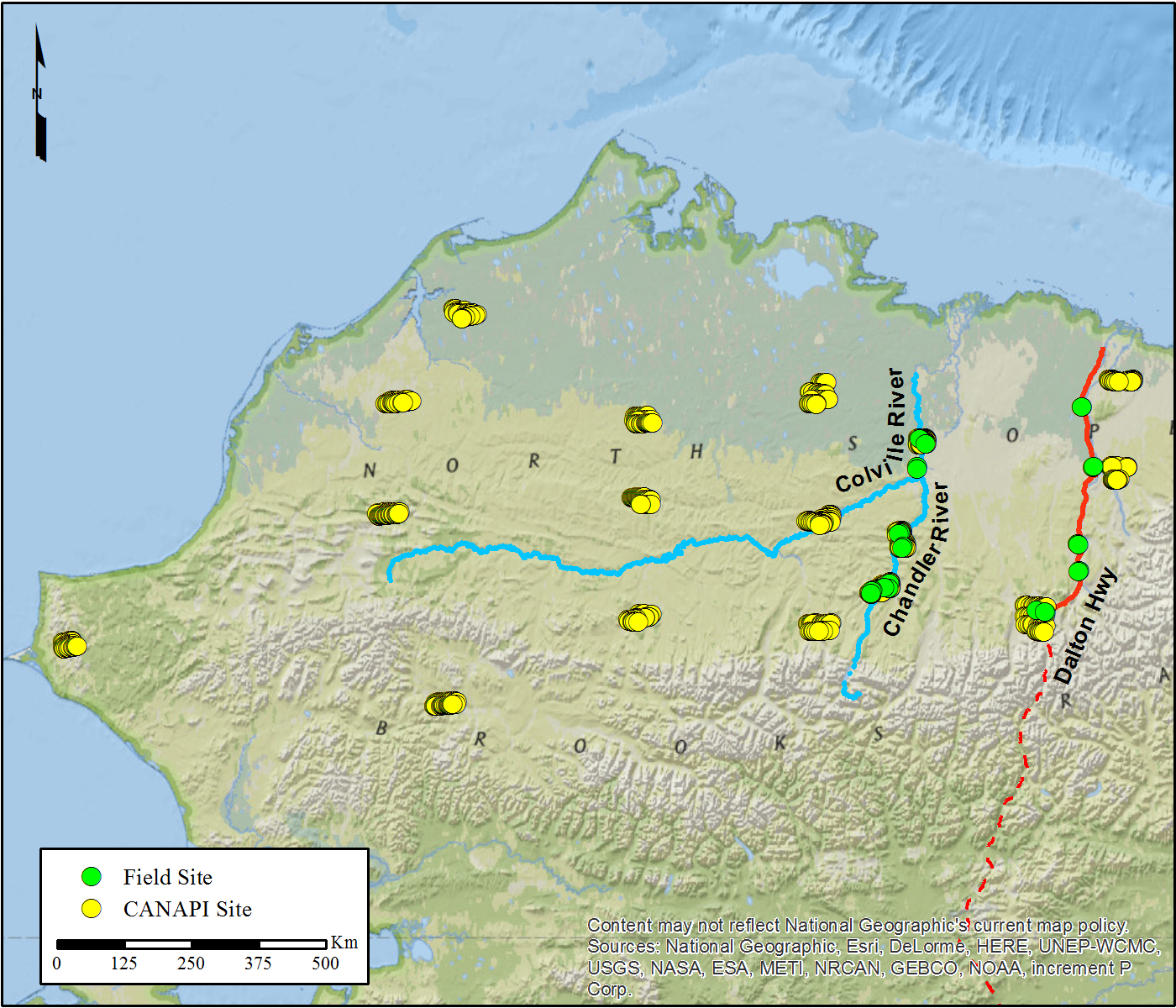
NACP Woody Vegetation Characteristics of 1,039 Sites across North Slope, Alaska, V2
National Aeronautics and Space Administration —
This data set provides the results of (1) field measurements of woody vegetation (shrubs) at 26 diverse sites across the North Slope of Alaska during 2010 and 2011,... -
Federal
SE-590 Landscape Reflectances (OTTER)
National Aeronautics and Space Administration —
Bidirectional spectral reflectance factors of landscape elements (litter, scrubs and grasses, leaves) measured by the Spectron SE590 spectroradiometer. -
Federal
LBA-ECO LC-23 Vegetation Fire Data, Roraima , Brazil: 2003
National Aeronautics and Space Administration —
The ASTER high resolution satellite data are available for visible-near infrared (15m resolution), short wave infrared (30m), and thermal infrared (90m) bands. Two...

Official websites use .gov
A
.gov website belongs to an official government
organization in the United States.
Secure .gov websites use HTTPS
A
lock (
) or https:// means you’ve safely connected to
the .gov website. Share sensitive information only on official,
secure websites.