
-
Federal
GOES-R PLT Lightning Instrument Package (LIP) V1
National Aeronautics and Space Administration —
The GOES-R PLT Lightning Instrument Package (LIP) dataset consists of electrical field measurements of lightning and navigation data collected by the Lightning... -
Federal
GOES-R PLT Airborne Visible/Infrared Imaging Spectrometer (AVIRIS) V1
National Aeronautics and Space Administration —
The GOES-R PLT Airborne Visible/Infrared Imaging Spectrometer (AVIRIS) dataset consists of radiance, reflectance, water phase, and navigation data delivered by the... -
Federal
GOES-R PLT Southern Ontario Lightning Mapping Array (LMA) V1
National Aeronautics and Space Administration —
The GOES-R PLT Southern Ontario Lightning Mapping Array (LMA) dataset consists of total lightning data measured from the Southern Ontario LMA (SOLMA) network during... -
Federal
GOES-R PLT Field Campaign Airborne Visible/Infrared Imaging Spectrometer Next Generation (AVIRIS-NG) V1
National Aeronautics and Space Administration —
The GOES-R PLT Field Campaign Airborne Visible/Infrared Imaging Spectrometer Next Generation (AVIRIS-NG) dataset consists of radiance, reflectance, water phase, and... -
Federal
GPM Ground Validation NASA ER-2 Navigation Data OLYMPEX V1
National Aeronautics and Space Administration —
The GPM Ground Validation NASA ER-2 Navigation Data OLYMPEX dataset supplies navigation data collected by the NASA ER-2 aircraft for flights that occurred during... -
Federal
Microwave Data CPEX
National Aeronautics and Space Administration —
The Microwave Data CPEX dataset consists of data collected from the Advanced Microwave Scanning Radiometer 2 (AMSR2), Global Precipitation Measurement Microwave... -
Federal
Global Hawk Navigation EPOCH
National Aeronautics and Space Administration —
The Global Hawk Navigation EPOCH dataset consists of the real-time navigation and housekeeping data that was acquired by various instruments aboard the Global Hawk... -
Federal
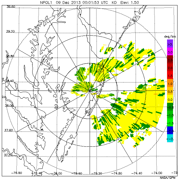
GPM Ground Validation NASA S-Band Dual Polarimetric (NPOL) Doppler Radar Wallops Flight Facility (WFF) V1
National Aeronautics and Space Administration —
The GPM Ground Validation NASA S-Band Dual-Polarimetric (NPOL) Doppler Radar Wallops Flight Facility (WFF) dataset consists of rain rate, reflectivity, Doppler... -
Federal
GOES-R PLT North Alabama Lightning Mapping Array (LMA) V1
National Aeronautics and Space Administration —
The GOES-R PLT North Alabama Lightning Mapping Array (LMA) dataset consists of total lightning data measured from the North Alabama LMA (NALMA) network during the... -
Federal
GOES-R PLT Geostationary Coastal and Air Pollution Event (GEO-CAPE) Airborne Simulator (GCAS) V1
National Aeronautics and Space Administration —
The GOES-R PLT Geostationary Coastal and Air Pollution Event (GEO-CAPE) Airborne Simulator (GCAS) dataset consist of solar backscattered radiation measured by the... -
Federal
GOES-R PLT Cloud Physics LiDAR (CPL) V1
National Aeronautics and Space Administration —
The GOES-R PLT Cloud Physics Lidar (CPL) dataset consists of backscatter coefficient, lidar depolarization ratio, layer top/base height, layer type, particulate... -
Federal
Microwave Atmospheric Sounder on Cubesat (MASC) CPEX V1
National Aeronautics and Space Administration —
The Microwave Atmospheric Sounder on Cubesat (MASC) CPEX dataset contains products obtained from the MASC instrument onboard the DC-8 aircraft. These data were... -
Federal
GOES-R PLT Field Campaign Airborne Visible/Infrared Imaging Spectrometer Next Generation (AVIRIS-NG)
National Aeronautics and Space Administration —
The GOES-R PLT Field Campaign Airborne Visible/Infrared Imaging Spectrometer Next Generation (AVIRIS-NG) dataset consists of radiance, reflectance, water phase, and... -
Federal
GOES-R PLT Airborne Visible/Infrared Imaging Spectrometer (AVIRIS)
National Aeronautics and Space Administration —
The GOES-R PLT Airborne Visible/Infrared Imaging Spectrometer (AVIRIS) dataset consists of radiance, reflectance, water phase, and navigation data delivered by the... -
Federal
GOES-R Geostationary Lightning Mapper (GLM) Gridded Data Products
National Aeronautics and Space Administration —
The GOES-R Geostationary Lightning Mapper (GLM) Gridded Data Products consist of full disk extent gridded lightning flash data collected by the Geostationary... -
Federal
GOES-R PLT Surface Radiance Ivanpah V1
National Aeronautics and Space Administration —
The GOES-R PLT Field Campaign Ivanpah dataset consists of surface reflectance and total optical depth data measured at Ivanpah Playa, Nevada during the GOES-R Post... -
Federal
Geostationary Lightning Mapper (GLM) Cluster Integrity, Exception Resolution, and Reclustering Algorithm (CIERRA)
National Aeronautics and Space Administration —
The Geostationary Lightning Mapper (GLM) Cluster Integrity, Exception Resolution, and Reclustering Algorithm (CIERRA) dataset consists of a hierarchy of earth-located... -
Federal
GOES-R PLT Cloud Physics LiDAR (CPL)
National Aeronautics and Space Administration —
The GOES-R PLT Cloud Physics Lidar (CPL) dataset consists of backscatter coefficient, lidar depolarization ratio, layer top/base height, layer type, particulate... -
Federal
GPM Ground Validation Duke Parsivel IPHEx V1
National Aeronautics and Space Administration —
The GPM Ground Validation Duke Parsivel IPHEx dataset were collected during the GPM Ground Validation Integrated Precipitation and Hydrology Experiment (IPHEx) field...

Official websites use .gov
A
.gov website belongs to an official government
organization in the United States.
Secure .gov websites use HTTPS
A
lock (
) or https:// means you’ve safely connected to
the .gov website. Share sensitive information only on official,
secure websites.