
-
Federal
ADVANCED MICROWAVE SOUNDING UNIT-A (AMSU-A) SWATH FROM NOAA-15
National Aeronautics and Space Administration —
AMSU-A, the Advanced Microwave Sounding Unit, is a 15-channel passive microwave radiometer used to profile atmospheric temperature and moisture from the earth's... -
Federal
Geostationary Lightning Mapper (GLM) Thunder Hour Data Product
National Aeronautics and Space Administration —
The Geostationary Lightning Mapper (GLM) is the first optical lightning detector in geostationary orbit, and GLM sensors operate aboard the National Oceanic and... -
Federal
RSS SSM/I OCEAN PRODUCT GRIDS WEEKLY AVERAGE FROM DMSP F13 NETCDF V7
National Aeronautics and Space Administration —
The RSS SSM/I Ocean Product Grids Weekly Average from DMSP F13 netCDF dataset is part of the collection of Special Sensor Microwave/Imager (SSM/I) and Special Sensor... -
Federal
GPM Ground Validation Conical Scanning Millimeter-wave Imaging Radiometer (CoSMIR) OLYMPEX
National Aeronautics and Space Administration —
The GPM Ground Validation Conical Scanning Millimeter-wave Imaging Radiometer (CoSMIR) OLYMPEX dataset consists of brightness temperatures from 9 channels as measured... -
Federal
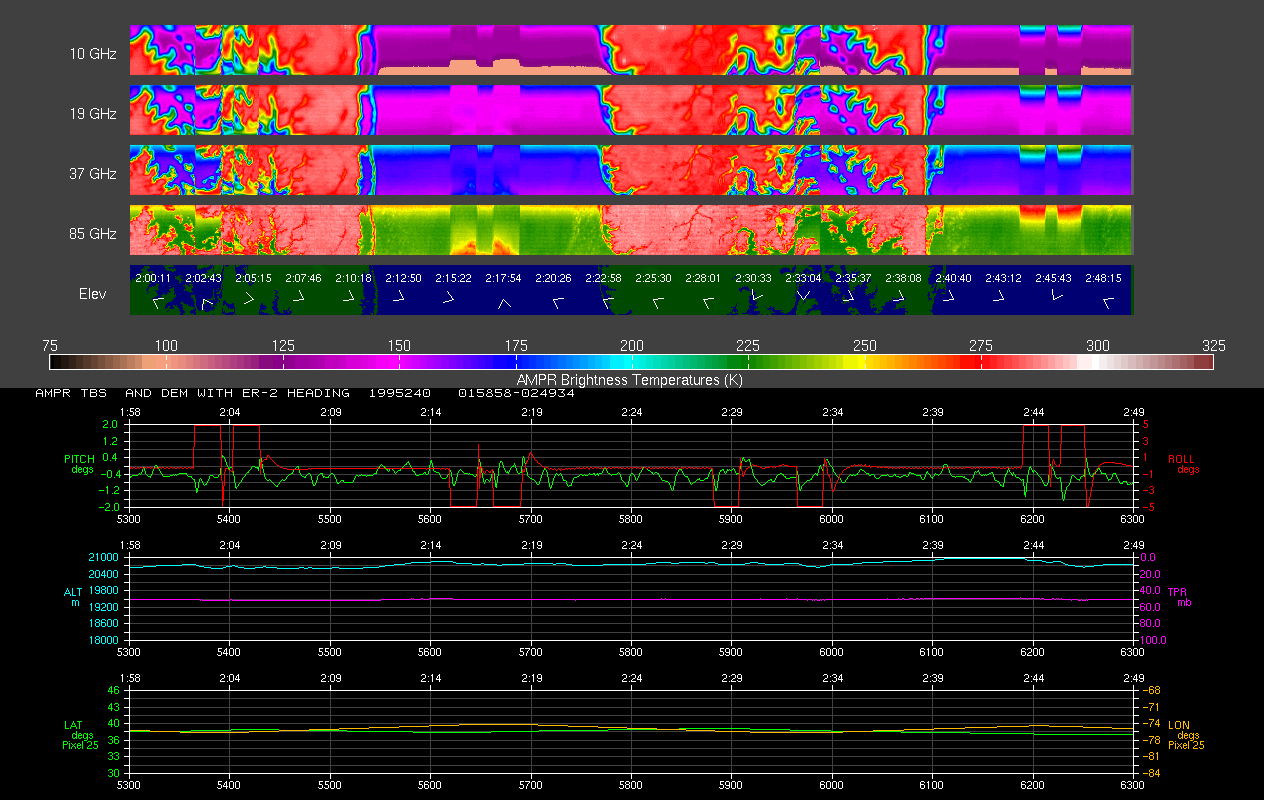
AMPR BRIGHTNESS TEMPERATURE CAMEX-2 V2
National Aeronautics and Space Administration —
The Advanced Microwave Precipitation Radiometer (AMPR) was deployed during the Convection and Moisture Experiment 2 (CAMEX-2). AMPR data were collected at a... -
Federal
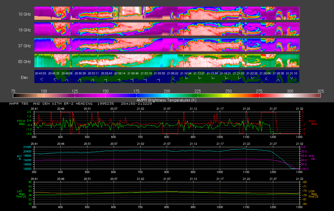
AMPR BRIGHTNESS TEMPERATURE CAMEX-1 V2
National Aeronautics and Space Administration —
The Advanced Microwave Precipitation Radiometer (AMPR) was deployed during the Convection and Moisture Experiments (CAMEX-1) conducted at Wallops Island, VA. AMPR... -
Federal
RSS SSM/I OCEAN PRODUCT GRIDS WEEKLY AVERAGE FROM DMSP F14 NETCDF V7
National Aeronautics and Space Administration —
The RSS SSM/I Ocean Product Grids Weekly Average from DMSP F14 netCDF dataset is part of the collection of Special Sensor Microwave/Imager (SSM/I) and Special Sensor... -
Federal
NAMMA PRAIA CAPE VERDE RADIOSONDE V1
National Aeronautics and Space Administration —
The NAMMA Praia Cape Verde Radiosonde data used Sippican MarkIIa DGPS (LOS) radiosondes, which were launched in support of NASA African Monsoon Multidisciplinary... -
Federal
GPM Ground Validation NASA EPFL-LTE Parsivel DSD Data Lausanne, Switzerland V1
National Aeronautics and Space Administration —
The GPM Ground Validation NASA EPFL-LTE Parsivel DSD Data Lausanne, Switzerland dataset consists of a network of 16 Parsivel disdrometers deployed on the Ecole... -
Federal
GRIP GOES 13 OVERSHOOTING TOP V1
National Aeronautics and Space Administration —
The GRIP GOES 13 Overshooting Top dataset was produced during the GRIP Field Experiment for use with the Real Time Mission Monitor (RTMM) tool. The major goal was to... -
Federal
LIS/OTD 2.5 Degree Low Resolution Time Series (LRTS) V2.3.2015
National Aeronautics and Space Administration —
The LIS/OTD 2.5 Degree Low Resolution Time Series (LRTS) contains a variety of gridded climatologies of total lightning flash rates obtained from two lightning... -
Federal
GRIP FLIGHT TRACKS AND ANIMATIONS V1
National Aeronautics and Space Administration —
The GRIP Flight Tracks and Animations dataset includes both KML files and animation files. The KML files use Google Earth to show the flight tracks on a map. The... -
Federal
GPM GROUND VALIDATION GOES 13 VISIBLE AND INFRARED IMAGES MC3E V1
National Aeronautics and Space Administration —
The GPM Ground Validation GOES 13 Visible and Infrared Images MC3E dataset was produced and archived in near real time at the Global Hydrology Research Center... -
Federal
Integrated Multi-satellitE Retrievals for GPM (IMERG) CPEX V1
National Aeronautics and Space Administration —
The Integrated Multi-satellitE Retrievals for GPM (IMERG) CPEX dataset includes measurements gathered by IMERG during the Convective Processes Experiment (CPEX) field... -
Federal
RSS SSM/I OCEAN PRODUCT GRIDS 3-DAY AVERAGE FROM DMSP F15 NETCDF V7
National Aeronautics and Space Administration —
The RSS SSM/I Ocean Product Grids 3-Day Average from DMSP F15 netCDF dataset is part of the collection of Special Sensor Microwave/Imager (SSM/I) and Special Sensor... -
Federal
HURRICANE AND SEVERE STORM SENTINEL (HS3) GLOBAL HAWK NAVIGATION V1
National Aeronautics and Space Administration —
The Hurricane and Severe Storm Sentinel (HS3) Global Hawk Navigation dataset consists of the real-time navigation and housekeeping data that was acquired from various... -
Federal
CAMEX-4 DC-8 INFORMATION COLLECTION AND TRANSMISSION SYSTEM V1
National Aeronautics and Space Administration —
The CAMEX-4 DC-8 Information Collection and Transmission System dataset was collected by the Information Collection and Transmission System (ICATS), which is designed... -
Federal
GOES-R PLT Kennedy Space Center Lightning Mapping Array (LMA) V1
National Aeronautics and Space Administration —
The GOES-R PLT Kennedy Space Center Lightning Mapping Array (LMA) dataset consists of total lightning data measured from the Kennedy Space Center LMA (KSCLMA) network... -
Federal
GOES-R PLT Washington D.C. Lightning Mapping Array (LMA) V1
National Aeronautics and Space Administration —
The GOES-R PLT Washington D.C. Lightning Mapping Array (LMA) dataset consists of total lightning data measured from the Washington D.C. LMA (DCLMA) network during the... -
Federal
GPM GROUND VALIDATION NASA ER-2 NAVIGATION DATA MC3E V1
National Aeronautics and Space Administration —
The GPM Ground Validation NASA ER-2 Navigation Data MC3E dataset contains information recorded by an on board navigation recorder (NavRec). In addition to typical...

Official websites use .gov
A
.gov website belongs to an official government
organization in the United States.
Secure .gov websites use HTTPS
A
lock (
) or https:// means you’ve safely connected to
the .gov website. Share sensitive information only on official,
secure websites.