
-
Federal
TERRA MODIS High Resolution Level 3 daily aerosol data, 0.1x0.1 degree grid Version 001 (AER_DBDT_D10KM_L3_MODIS_TERRA) at GES DISC
National Aeronautics and Space Administration —
This High-Resolution (0.1 x 0.1 degree) Level 3 daily Aerosol Optical Depth (AOD) product is generated by combining two Moderate Resolution Imaging Spectroradiometer... -
Federal
GLDAS Catchment Land Surface Model L4 daily 0.25 x 0.25 degree GRACE-DA1 V2.2 (GLDAS_CLSM025_DA1_D) at GES DISC
National Aeronautics and Space Administration —
NASA Global Land Data Assimilation System Version 2 (GLDAS-2) has three components: GLDAS-2.0, GLDAS-2.1, and GLDAS-2.2. GLDAS-2.0 is forced entirely with the... -
Federal
MLS/Aura Level 3 Daily Binned Methyl Chloride (CH3Cl) Mixing Ratio on Assorted Grids V004 (ML3DBCH3CL) at GES DISC
National Aeronautics and Space Administration —
ML3DBCH3CL is the EOS Aura Microwave Limb Sounder (MLS) daily binned on various vertical grids product for methyl chloride (CH3Cl) derived from radiances measured by... -
Federal
GPM MHS on NOAA18 (GPROF) Radiometer Precipitation Profiling L3 1 month 0.25 degree x 0.25 degree V07 (GPM_3GPROFNOAA18MHS_CLIM) at GES DISC
National Aeronautics and Space Administration —
Version 07 is the current version of the data set. Older versions are no longer available and have been superseded by Version 07. The "CLIM" products differ from... -
Federal
MLS/Aura Level 2 Ozone (O3) Mixing Ratio V005 (ML2O3) at GES DISC
National Aeronautics and Space Administration —
ML2O3 is the EOS Aura Microwave Limb Sounder (MLS) standard product for ozone derived from radiances measured by the 240 GHz radiometer. The data version is 5.0.... -
Federal
AQUA MODIS High Resolution Level 3 daily aerosol data, 0.1x0.1 degree grid Version 001 (AER_DBDT_D10KM_L3_MODIS_AQUA) at GES DISC
National Aeronautics and Space Administration —
This High-Resolution (0.1 x 0.1 degree) Level 3 daily Aerosol Optical Depth (AOD) product is generated by combining two Moderate Resolution Imaging Spectroradiometer... -
Federal
GLDAS Noah Land Surface Model L4 monthly 1.0 x 1.0 degree V2.1 (GLDAS_NOAH10_M) at GES DISC
National Aeronautics and Space Administration —
NASA Global Land Data Assimilation System Version 2 (GLDAS-2) has three components: GLDAS-2.0, GLDAS-2.1, and GLDAS-2.2. GLDAS-2.0 is forced entirely with the... -
Federal
GPM AMSUB on NOAA15 (GPROF) Climate-based Radiometer Precipitation Profiling L3 1 day 0.25 degree x 0.25 degree V07 (GPM_3GPROFNOAA15AMSUB_DAY_CLIM) at GES DISC
National Aeronautics and Space Administration —
The "CLIM" products differ from their "regular" counterparts (without the "CLIM" in the name) by the ancillary data they use. They are Climate-Reference products,... -
Federal
Aqua/AIRS L2 Near Real Time (NRT) Standard Physical Retrieval (AIRS-only) V7.0 at GES DISC
National Aeronautics and Space Administration —
The Atmospheric Infrared Sounder (AIRS) Level 2 Near Real Time (NRT) Standard Physical Retrieval (AIRS-only) product (AIRS2RET_NRT_7.0) differs from the routine... -
Federal
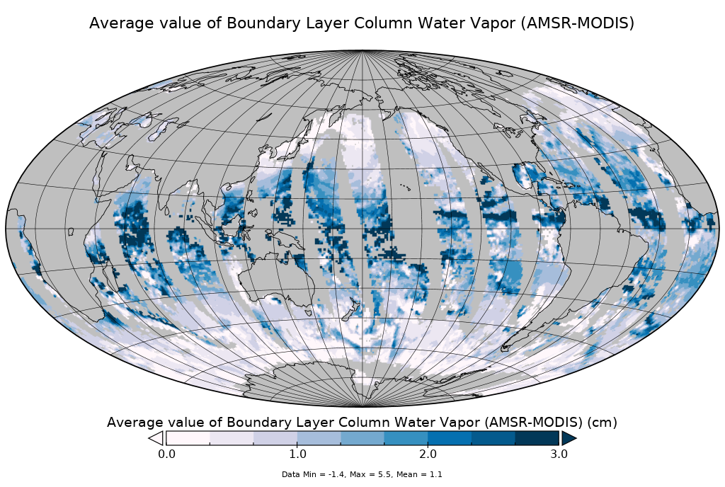
AMSR-MODIS Boundary Layer Water Vapor L3 Daily 1 degree x 1 degree V2 (AMDBLWV) at GES DISC
National Aeronautics and Space Administration —
Version 2 is the current version of this dataset. Version 2 uses an improved methodology to screen out high clouds.This data set provides an estimate the marine... -
Federal
Sounder SIPS: Suomi NPP CrIMSS Level 3 Comprehensive Quality Control Gridded Daily CHART Normal Spectral Resolution V1
National Aeronautics and Space Administration —
The objective of this limited edition data collection is to examine products generated by the Climate Heritage AIRS Retrieval Technique (CHART) algorithm to analyze... -
Federal
GPM ATMS on NOAA-21 (GPROF) Climate-based Radiometer Precipitation Profiling L2A 1.5 hours 17 km V07 (GPM_2AGPROFNOAA21ATMS_CLIM) at GES DISC
National Aeronautics and Space Administration —
Version 07 is the current version of the data set. The "CLIM" products differ from their "regular" counterparts (without the "CLIM" in the name) by the ancillary data... -
Federal
MERRA-2 instM_3d_asm_Np: 3d,Monthly mean,Instantaneous,Pressure-Level,Assimilation,Assimilated Meteorological Fields 0.625 x 0.5 degree V5.12.4 (M2IMNPASM) at GES DISC
National Aeronautics and Space Administration —
M2IMNPASM (or instM_3d_asm_Np) is an instantaneous 3-dimensional monthly mean data collection in Modern-Era Retrospective analysis for Research and Applications... -
Federal
Sounder SIPS: Suomi NPP CrIMSS Level 2 CLIMCAPS Normal Spectral Resolution: Atmospheric state at Standard Pressure Levels derived from CLIMCAPS V2.1 (SNDRSNIML2PLEVCPSN) at GES DISC
National Aeronautics and Space Administration —
The CLIMCAPS (Community Long-term Infrared Microwave Coupled Product System) algorithm is used to analyze data from the Cross-track Infrared Sounder/Advanced... -
Federal
GLDAS Catchment Land Surface Model L4 monthly 1.0 x 1.0 degree Early Product V2.1 (GLDAS_CLSM10_M_EP) at GES DISC
National Aeronautics and Space Administration —
NASA Global Land Data Assimilation System Version 2 (GLDAS-2) has three components: GLDAS-2.0, GLDAS-2.1, and GLDAS-2.2. GLDAS-2.0 is forced entirely with the... -
Federal
NLDAS Secondary Forcing Data L4 Hourly 0.125 x 0.125 degree V2.0 (NLDAS_FORB0125_H) at GES DISC
National Aeronautics and Space Administration —
This data set contains the secondary forcing hourly data "File B" for Phase 2 of the North American Land Data Assimilation System (NLDAS-2). The data are in 1/8th... -
Federal
NOAA20 VIIRS High Resolution Level 3 daily aerosol data, 0.1x0.1 degree grid Version 001 (AER_DBDT_D10KM_L3_VIIRS_NOAA20) at GES DISC
National Aeronautics and Space Administration —
This High-Resolution (0.1 x 0.1 degree) Level 3 daily Aerosol Optical Depth (AOD) product is generated by combining two Visible Infrared Imaging Radiometer Suite... -
Federal
NLDAS Mosaic Land Surface Model L4 Monthly 0.125 x 0.125 degree V2.0 (NLDAS_MOS0125_M) at GES DISC
National Aeronautics and Space Administration —
This data set contains thirty-seven fields simulated from the Mosaic land-surface model (LSM) for Phase 2 of the North American Land Data Assimilation System... -
Federal
TSIS SIM Level 3 Solar Spectral Irradiance 12-Hour Means V13 (TSIS_SSI_L3_12HR) at GES DISC
National Aeronautics and Space Administration —
Version 13 is the current release of this data product, and supercedes all previous versions.The TSIS SIM Level 3 Solar Spectral Irradiance (SSI) 12-Hour Means data... -
Federal
Sounder SIPS: AQUA AIRS IR + MW Level 2 CLIMCAPS: Atmosphere, cloud and surface geophysical state V2 (SNDRAQIML2CCPRET) at GES DISC
National Aeronautics and Space Administration —
WARNING: To users of the derived product “co_mmr_midtrop” (carbon monoxide mass mixing ratio to dry air [kg/kg] at ~500 hPa). This variable has a significant bias due...

Official websites use .gov
A
.gov website belongs to an official government
organization in the United States.
Secure .gov websites use HTTPS
A
lock (
) or https:// means you’ve safely connected to
the .gov website. Share sensitive information only on official,
secure websites.